 English resume
Impact rapid decrease water level
Using a water storage area could lead to a similar decrease in the storage basin level and create geotechnical problems when the water storage level decreases rapidly and the high water pressure in the saturated dike does not decrease at the same time. This may create shearing or washout hazards.
|
Thema |
Waterveiligheid, Delta facts, English versions |
|
Tags |
|
|
Downloads |
- INTRODUCTION
- RELATED TOPICS AND DELTA FACTS
- MULTILAYER SAFETY STRATEGY
- SCHEMATIC
- TECHNICAL SPECIFICATIONS
- MEASURES AND SOLUTIONS
- COSTS AND BENEFITS
- LESSONS LEARNED AND ON-GOING STUDY
- KNOWLEDGE GAPS
- EXPERIENCES
Introduction
The reason this issue needs to be given thoughtful consideration is the dike failure in Wilnis, which led to the rapid decrease in the storage basin level and damage to the secondary dike. Using a water storage area could lead to a similar decrease in the storage basin level and create geotechnical problems when the water storage level decreases rapidly and the high water pressure in the saturated dike does not decrease at the same time. This may create shearing or washout hazards.
It should be noted that there is no evidence linking the occurrence of this problem with the water storage.
Related topics and Delta facts
Keywords: storage area, standardising secondary dikes, water storage.
Delta Facts: The stability of peat dikes
Multilayer safety strategy
Multilayer safety can be categorised into three main areas:
1 Prevention, 2 Spatial Planning, 3 Crisis Management
This topic falls under the first layer, prevention, as it involves a measure that produces an undesirable consequence (instability caused by use of storage area)
Schematic
Rapid water level decrease in a storage basin system may be caused by:
- dike fracture
- using a storage area
Storage areas are used in the storage basin system to ensure that secondary dikes meet the safety standards. They are used to remove the excess water in the storage basin system from the storage basin and to lower the local water level. A storage area is therefore a regulated system, where the storage is used to control the water level. In other words, rather than raise the barrier, the water level is lowered instead. In spatial planning, the storage area is characterised as a rural area with a water storage function.
For the rapid decrease in water level to have any possible impact on the flood defence, the decrease has to be significant (for example from 0.5 to 1.0 m, according to the interview with Meindert Van). In most cases, this impact will not occur if the storage area is situated adjacent to the storage basin, because the level decrease is often 30 cm or less (the same level decrease as when a storage basin pumping station is used). The level decrease at the inlet point may well be higher, but the inlet construction will be adapted to avoid this. In addition, the storage area should be designed to allow for a controlled level decrease. This is determined by the location of the storage area and the location of the inlet in the storage basin. The design flow velocity must not be too high or it will erode the bottom of the storage basin. The storage basin level may however decrease significantly if a breach or failure occurs, in which case the source of the problem is not a control measure, but a disaster.
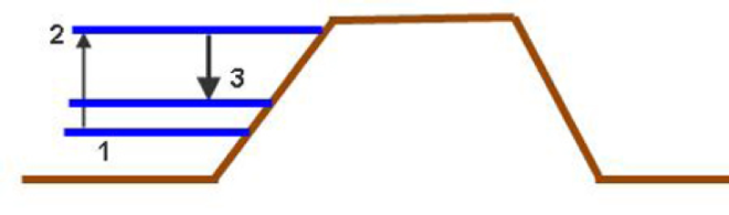
This figure shows the water level development
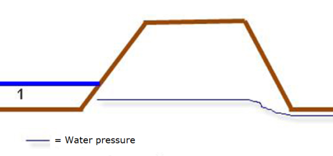
Situation 1: neutral situation
In situation 1, there is a normal level with low water pressure. The groundwater flow finds its way to the downstream polder level.
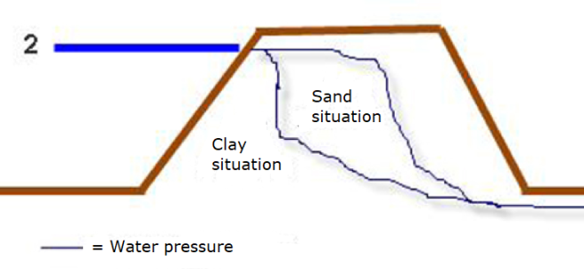
Situation 2: high water level
When the water level rises as a result of precipitation or increased water discharge, it creates higher water pressure, causing water to infiltrate the dike and the groundwater to rise to a higher level in the flood defence.
One important factor is the permeability of the dike, which depends on the soil type, where clay is the least permeable, then peat and sand, respectively. The occurrence of shear instability (failure mechanism) is counteracted by the high river or storage basin level. The saturation level of a dike depends on the type of dike due to the complexity of the dike structure.
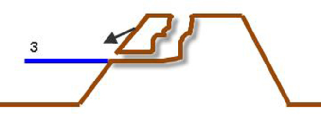
Situation 3: rapid water level decrease
In the event of a rapid decrease in the water level, the infiltrated water drains out of the dike body. The water has created extra weight in the dike and in combination with the water pressure, could cause different failure mechanisms:
- inward instability: large downward movement of a section of soil in response to a slip circle in the slope (situation in Figure 3)
- micro-instability; small-scale erosion of particles (washout). Problems related to micro-instability can occur at both the inner and outer slope.
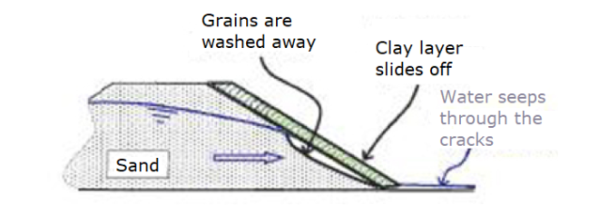
Source: Figure 1.3 from de Groot (2008)
The following two parameters are leading for situation 3:
- permeability of the dike's soil type in relation to the impact on water pressure level and saturation velocity of the flood defence
- soil strength in relation to impact on landslide
Technical specifications
The impact of rapid decrease in water level can be rationalised on the basis of the following formula:
![]()
T (shear stress) = c (cohesion) + (effective stress = soil stress - water pressure) x tan (constant with regard to internal friction angle)
The shear stress decreases as the water level rises, after all the effective stress decreases as the water pressure increases. When the shear stress decreases so does the strength. This is primarily compensated because the high water in front of the dike provides the dike with sufficient support. If the water level decreases rapidly, the support or counter-pressure from the water decreases as well and the outcome could be shear occurring.
The amount of level decrease and its consequences on dike stability depend on:
- hydraulic roughness of the slope and water system
- surface of the storage basin system
- water decrease rate
- slope steepness
- presence of revetment and its quality
- dike construction materials (type of dike materials used)
- storage basin depth
Reaching a critical point therefore depends on the location.
Although a potential shear would require repair costs to be incurred, it will not compromise safety in the short term. The low water level is not likely to create immediate inundation in the hinterland. A potential risk that exists is that the water may rise again while the dike is still saturated or still needs to be repaired. In this case, inundation could occur.
A similar failure mechanism involving rapid level decrease is observed in irrigation areas where ditch banks collapse water when water supply stops. Water level decrease in a lock chamber can also lead to a similar mechanism.
Measures and solutions
A number of measures and solutions can be considered for situations in which first high water level and then rapid level decrease may occur:
- compartmentalisation of the storage basin system (in case of dike fracture)
- reducing the water level decrease rate by controlling the structures or by choosing an appropriate location (e.g. near a lake) (in the event of using a water storage area)
- constructing a support verge to prevent the dike from collapsing (a problem is that because of the high water level it is difficult to construct this at the toe of the waterfront)
- covering the surface of the dike with a thick layer of clay to reduce permeability
- stopping shipping traffic at high tide in connection with waves and vibration. The same may apply to trucks. If a dike is saturated, the weight and vibration caused by a truck may increase the probability of shear slip. In case of rapid decrease, the road on the dike can be closed off to freight traffic.
Costs and benefits
Costs typically involve shear repair, damage due to dike fracture and/or necessary mitigating measures.
Lessons learned and on-going study
Hunze en Aa’s Water Board is busy researching this at present, see experiences.
Knowledge gaps
The first and most important knowledge gap is that it is unknown whether and under which conditions this problem occurs.
The flood risk is generally determined as the product of the probability of an event and the impact of that event. In light of this, how bad is a shear after rapid decrease? There will be costs for repairs, but probably no inundation. A flood event will likely occur only if rapid water decrease and rise take place in quick succession to each other. However, the probability of this occurring is unknown, which in itself is a good reason for further research.
Stability problems due to rapid decrease is rare, most problems are expected to occur during the course of research. The premise is that inward instability equals outward instability, whereby the same sums are used. However, this is not further substantiated.
When the Wilnis peat dike sustained large shear deformation, various places in the storage basin also exhibited outward shear due to the rapid decrease in the storage basin level (in the order of one metre lowering), but this was not investigated further.
In the disaster that played out at the lock in Delfzijl (Famsum) in early 2000, the level in the Eems Canal decreased sharply in a matter of few hours. This was estimated to be about 1 to 2 metres from the lock. None of the dikes along the Eems Canal sustained shearing or damage.
Experiences
Lessons Learned from the flood event of 1998 regarding the use of a storage area
Interview of November 22, 2011 with Mr H. van der Leij of Hunze and Aa's Water Board.
In 1998, several storage areas were used to accommodate the high water level that had inundated the Omer and Oostpolder, among others.
Use of the storage area translated into the following positive results:
- relatively little soil damage
- a number of dikes along the Drents Diep were quite low in structure at the time, allowing the water to flow over them and the storage basin level in other locations to rise less rapidly
A negative result may be the washout of the canal bed and the damage in the polder. In 1998, in Tussenklappolder, the dike across from the breach nearly collapsed as result of the soil washout, the soil was completely worn away and the toe of the dike across the street was almost torn away. Thus in the new designation the Tussenklopperpolder was not included as a storage area.
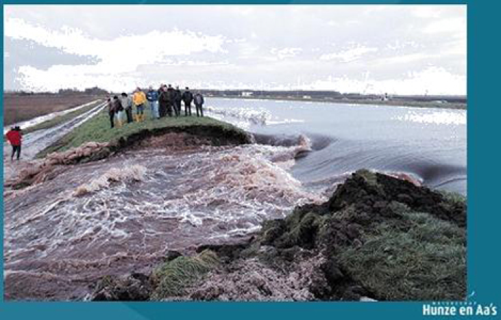
Picture of Tussenklappolder ‘ 98
Facilities provided, based on the information from 1998:
- Opening in dike to allow an area to be filled up quickly
- Dikes with cut-offs have been placed around vulnerable facilities in the storage area
- Model of the storage basin has been created to facilitate water level forecasts
- Sequence order prepared for the use of storage areas. Using the storage areas in a specific order seems to be very important, since the direction of the high water is determinative.
- Seepage walls erected and local reinforcements installed
- Overflow sills and revetment for the dike and canal bed to prevent washout of canal and polder side into the soil
A study is currently underway in the water board using a computer model (Finite Element Analysis (FEA)) that identifies failure mechanisms in retention areas. The rapidly receding water can create a negative pore-water pressure in certain soil types and under certain conditions, which increases the probability of shear in the slope region. The course of this process is mapped with FEA. The first analysis shows that the Winschoten storage area may sustain shear deformations due to rapid level decrease in storage basin.