 English resume
Reserve area
The reserve area is under pressure due to lack of space. It is frequently tapped out, while the water board has proclaimed it as a reserve for future safety. This Delta Fact provides an overview of the legal framework and the implementation by water boards.
|
Thema |
Waterveiligheid, Delta facts, English versions |
|
Tags |
|
|
Downloads |
- INTRODUCTION
- RELATED TOPICS AND DELTA FACTS
- STRATEGY: MULTILAYER SAFETY
- SCHEMATIC
- TECHNICAL SPECIFICATIONS
- POSITIONING
- GOVERNANCE
- LESSONS LEARNED AND ON-GOING STUDY
Introduction
The reserve area is under pressure due to lack of space. It is frequently tapped out, while the water board has proclaimed it as a reserve for future safety. This Delta Fact provides an overview of the legal framework and the implementation by water boards.
The zoning system regarding flood defences is described first, followed by a detailed description of the relationship between reserve area and spatial planning.
It should be noted that a debate is currently underway about the terminology. In the new model, the regulations of the Association of Water Boards, a proposal will be made to replace the term reserve area (also called reserve strip) with 'free space profile'.
Related topics and Delta Facts
Keywords: Reserve strip, Regulations, Register, Free space profile
Delta Facts: Spatial development in and on flood defences
Strategy: multilayer safety
Multilayer safety can be categorised into three main areas:
1 Prevention, 2 Spatial Planning, 3 Crisis Management
The reserve area reserves space for future reinforcement or expansion of flood defences. This contributes to water safety and therefore falls under the first layer of multilayer safety, prevention. It also falls partly under spatial planning as part of registering the spatial reserve.
Schematic
The zoning policy is based on three zones:
- First zone: core area
- Second zone: (outside) protection area
- Third zone: reserve area
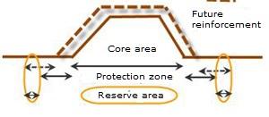
A water board has different interests in retaining areas:
- ensuring the function of the public works structure (first zone)
- ensuring the stability of the public works structure (second zone)
- ensuring the possibility to improve the public works structure in response to future needs (third zone)
It should be noted that the width of the protection area (second zone) can already meet the spatial reserve, therefore no separate space will need to be reserved outside that area, as the reserve area merges with the protection area.
The figure below shows a schematic of the zones for a sand barrier (dune barrier).
Overview of different zones (source: Coastal Sand Dune Guidelines). Note: This picture illustrates a situation where the reserve area merges into the protection area. The reserve area is located between the current and future boundary profile (red blocks). There is no need to map this separately, as long as the reserve area falls within the protection area and in the allocated dune area.
The Association of Water Boards is currently working on new model regulations, which will replace the model regulations of 2008. Consistency in terminology will also be pursued in the new model regulations:
- The current terminology core area and protection area will be consistent with public works structure.
- The current terminology outside protection area will be consistent with protection area.
- The current terminology reserve area (also referred to as defence area, spatial reserve or reserve strip) will be consistent with free space profile.
The prohibition regime per area will be determined by the Regulations or by the legislation in the management memoranda of the water boards. The areas are indicated in the Register. The prohibition regime is three-dimensional, reflecting the height, width and depth of the area. The normative slip circle, which can be calculated with a programme such as DAM, determines the size of zoning of the public works structure and the second and third zone derived from it, which is subject to a less restrictive regime. Pursuant to the Water Board Act and the Water Act, the water boards may use the areas as they see fit. Each water board has laid out the specifics regarding the use of the areas in the Regulations and the Register.
The same instruments apply to all three zones:
- The Water Act
- The Regulations/Register
Through mutual consultation, coordination will also be sought with:
- The structural policy (former regional plan) of the province
- The zoning plan of the municipality
The Barro (General Spatial Planning Rules Decree; known as Spatial Planning Act; Order in Council Spatial Planning, AMvB Ruimte) will be an influencing factor as well.
Technical specifications
Reserve areas are established to meet future needs and the duty-of-care obligations in regards to flood defences (i.e. keeping the floodplains habitable and safe). A distinction is made between reserve areas for rivers and coasts behind and outside dikes. The reserve area for a flood defence located along the coast is intended primarily for reserving space for carrying out reinforcement work over a future period of years, whereby the worst case scenario is chosen, 85cm per century. The basic principle for reinforcement of river dikes is every 50 years, where the next 50 years (total period of 100 years) should be taken into account. It is a temporary reserve for future reinforcement and expansion of the flood defence. This reserves continued accessibility for the manager to create a number of options:
- reinforce a flood defence in the future
- build a flood defence at a later time
The space is needed to ensure preparedness for:
- Climate change
- More stringent safety standards
- New (social) insights
(Coastal Sand Dune Guidelines, 2002)
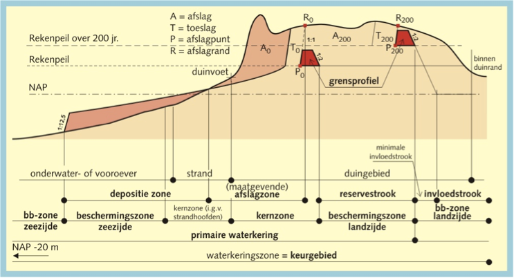
The determination of the size of the area depends on the location.
For coastal areas, a dune erosion model is used, which is also applied for testing and design. The basic principles are:
- 200-year sea level rise
- 10% higher storm surge
In addition, the margins may depend on:
- the environment (urban development or open area)
- characteristics of the public works structure.
For river regions, a fixed size is maintained. The Spatial Strategy Memoranda states the following: "Prior to potential reinforcement of the primary flood defences, no expansion of the existing buildings will be permitted in an area of 100 metres behind the dike and 175 metres outside the dike. (...) (...) The definitive areas will be determined in consultation among the government, the flood defence manager and the provinces, and will be incorporated in the regional plans, zoning plans and the registers of the water boards. For plans in advanced stages, the parties involved will provide tailor-made solutions.” (§ 4.6.4.2 Spatial Memoranda).
The reserve area does not have a uniform legal status as it is not defined in the Water Act, but it does fall under the Water Decree and therefore within the public works structure that is protected by the regulatory regime of the Regulations. It can apply to all public works structures, but is not a requirement. The reserve area provides an opportunity for water boards to impose a prohibition regime on third-party actions. To define an area as a reserve area, a justification must be drafted. It is easier to formulate a justification for a primary flood defence than for a secondary flood defence. The reserve area is given a status when it is recorded in the Register. The reserve area is subject to the least stringent regime of the three zones. This means that development in the area is possible as long as it is flexible and easily removable (this is a precondition), such as trees, plants, grazing grounds and simple standalone structures.
Since the General Spatial Planning Rules Decree (Barro) in August 2011 and the first supplement to the Barro has come into force, the reserve areas for primary flood defences must be incorporated in zoning plans or integration plans. With this, the spatial reserves for primary flood defences will also be embedded in the spatial domain.
The actual zoning lies in the policy and planning instruments (zoning plan and structural policy) of local and provincial authorities. A water board has an advisory role by virtue of the water assessment, and can therefore ensure the allotment of the spatial reserve stipulated in the Barro, acting in this context as owner. Each water board carries out the process as it sees fit, in consultation with local and provincial authorities. High-quality (capital-intensive) use of the space will be permitted only if the precondition of flexibility and removability is observed. The conditions are aimed at preventing irreversible developments that are detrimental to future reinforcements of the flood defence. An interesting interpretation is Tijdelijk Anders Bestemmen (Temporary Alternative Allocations) (TAB). The temporary activity can be exercised until the area needs to be used to ensure water safety. A reserve area can be temporarily used as a nature-friendly bank.
Positioning
The distinction between reserve area and protection area is due to the nature of the zone. A protection area is integrated with the barrier and is designed to protect the stability of the barrier. A reserve area, on the other hand, has not direct contact with the flood defence, but is a spatial reserve for future use.
It should be noted that the reserve area will become superfluous when a Delta Dike is installed, given that its design is climate-resistant and it is designed for a time period of 200 years.
Governance
As already mentioned, each water board will approach the implementation of the policy on the reserve area as it sees fit (whereby it should be noted that many water boards are already using the term free space profile). The Regulations determine what is and is not allowed in the reserve area. In most cases, this means that the installation of all structures is subject to a permit from the water board (according to the principle: No, unless), which poses a challenge for the water board as it must negotiate an intricate balance between the interests of the initiator and the interests of water safety. See also the Delta Fact Spatial development in and on flood defences. Below are some examples of how the reserve area/free space profile is incorporated in the Regulations of a water board and how the province addresses it:
Vallei & Eem Water Board
Free space profile: "the space on either side of and above a primary, regional or other flood defence which, in the opinion of the manager, is needed for future improvements to the flood defence and is registered as such in the Register; the profile is necessary to safeguard important land from irreversible interventions in the future. The free space profile is determined in accordance with the most likely hydraulic preconditions which may be stipulated in the future. Use of the free space profile for any purpose other than in accordance with the function in, on, above, over or below the structures is strictly prohibited without a (water) permit from the water board. (Vallei & Eem Water Board Regulations 2009)
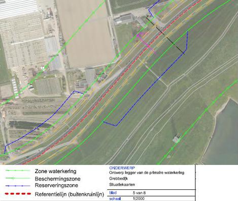
The water board has registered a reserve area in the Register based on this free space profile. The figure below shows a situation drawing of the Grebbe Dike. The reserve area within the boundaries of the protection area is shown in blue. The reserve area is always located on one side, the side without spatial development.
Rivierenland Water Board
Free space profile (FSP); ‘developments such as climate change and land subsidence will likely necessitate future dike reinforcements. Neither citizens nor the water board find it desirable to have to remove buildings, pipelines and other objects in the future to enable dike reinforcement. It is therefore important to position capital-intensive investments (e.g. buildings, pipelines, sports fields, etc.) in a way that dike reinforcements can be installed without demolition and/or other adjustments of capital-intensive investments. This is achieved by assessing the durability of these developments against the free space profile.
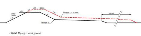
If the FSP is not registered in the Register, it will be determined as follows:
Because the prohibition does not allow for elevations to be provided in the winter bed of the river, inward reinforcement will be installed. The crest line height will be maintained at the level of the current dike table height (DTH). Based on the register profile, the outer slope will be extended to the DTH level + 1.00 metre. The following three failure mechanisms are important for determining the required berm dimensions:
- shearing (requires relatively short, high verge); elevation of the inner verge by 0.50 metres and widening the verge by 5.00 metres compared to the existing verge width.
- piping/uplift (requires a long, low berm); elevation of the inner berm by 1.00 metres and landward expansion by 18.00 metres (see figure)
- heave (requires a long, high berm); situation-specific dimensions (this depends on the thickness and composition of the weak layers in the subsoil)." (Rivierenland Water Board Regulations and Policy Rules 2010)
Province of South Holland
The provincial Spatial Regulations only refer to the core area and protection area and provide the applicable preconditions that allow for unobstructed operation, preservation and maintenance of the primary and regional flood defences. The Provincial Water Plan (2010-2015), on the other hand, offers room in other spatial policy principles to take into account an adjusted reserve strip or defence area around the primary and regional flood defences to allow for more climate-resiliency. The basic principles for this space are the applicable KNMI climate scenarios. In a dike reinforcement process, the province asks for a 50-year perspective on the dike reinforcement design in order to map the space.
Lessons learned and on-going study
The new Model Regulations of the Association of Water Boards is expected to be released in 2012, it will likely propose new terminology for zoning of public works structures.
An on-going point of discussion is that the reserve area is reserved in the Register, but is (still) not set out in a zoning plan. This will allow a municipality to zone the space for purposes other than flood defence. Therefore, in order to secure the flood defence objectives, water assessment will be performed but this is merely a recommendation. As observed in a study by Sterk Consulting en Delta Advies (2011, p. 2): "Because regulatory prohibitions often have a relative character (yes, provided that/no, unless) there is always room for discussion about how absolute the regulatory prohibition is. Many water boards are by and large flexible and solution-oriented, where in certain cases this causes the balance of interests to, perhaps, result in compromising the daily management and maintenance." Therefore, the size of the reserve area is also considered from the perspective of expansion/reinforcement of public works structure. Should the free space profile be expanded for a new situation or will the designated free space profile be utilised and will this leave less room for future reserves?
As part of the National Delta Programme (especially in the Development and Redevelopment sub-programme) options are currently being explored for utilising the reserve area along the coast and rivers. This will be included in the discussions on spatial planning and water safety. The areas that must be registered are also being examined.
The Aa en Maas Water Board has launched a contest (via Battle of Concepts) for innovative ideas for the use of the free space profile.