 English resume
Effects of climate change on agriculture
This delta fact addresses climate change, the effects of climate change on crop yield in agriculture, the models and calculation methods that are applied to forecast the effects and, the possibilities for adaptation.
|
Thema |
Zoetwatervoorziening, Delta facts, English versions |
|
Tags |
|
|
Downloads |
- INTRODUCTION
- RELATED TOPICS AND DELTA FACTS
- CLIMATE CHANGE
- CROP YIELDS
- CALCULATION METHODS FOR CROP PRODUCTION
- CLIMATE EFFECTS ON AGRICULTURAL CROPS
- ADAPTATION POSSIBILITIES FOR AGRICULTURE
- GOVERNANCE
- KNOWLEDGE GAPS
- OVERVIEW OF CURRENTLY ACTIVE RESEARCH PROJECTS
Introduction
Agriculture is an important cornerstone of the Dutch economy due to the food production and agricultural product export. In the past century, the yield of agricultural crops has increased tremendously. Dutch agriculture and horticulture accounts for 10% of the Dutch economy and employment opportunities. The annual export of agricultural products amounts to approximately € 65 billion. Agriculture fills a large portion of the space in the Netherlands and this contributes significantly to the social and ecological services such as the quality of the landscape, recreation and biodiversity.

The change in climate could have considerable consequences for agriculture, not only due to the direct changes in conditions for crops (milder winters, more drought, increase in C O2-concentration and the like) but also because of indirect effects such as new diseases, pests and plagues, a demand for different crops (e.g. bio-fuels) and the risks of business management (yield consistency). It is paramount that the sector and the authorities anticipate the risks and opportunities (of adaptation).
This delta fact addresses climate change, the effects of climate change on crop yield in agriculture, the models and calculation methods that are applied to forecast the effects and, the possibilities for adaptation. Much of the information is derived from the research programs ‘Climate changes Spatial Planning’ [Klimaat voor Ruimte] and ‘Knowledge for Climate’ [Kennis voor Klimaat]. Mitigating climate change by means of agriculture is outside the scope of this delta fact.
![]()
‘Climate Changes Spatial Planning’ studied the impact of climate change and ways in which to deal with it, using the lack of space as a way to support the decision-making about the country’s future spatial planning. This program was completed in December 2011.
‘Knowledge for Climate’ is mainly directed at the knowledge and the organization of that knowledge to make the Netherlands climate proof. The intention is to first make the Netherlands more climate proof and to then draw attention to this climate proofing and its accompanying knowledge base and experience, in order to enhance the climate for business establishment and strengthen the export position of climate and delta technology.
To cluster knowledge about climate change, a Climate portal was set up by the Platform Communication on Climate Change (PCCC). The PCCC is a co-operation of climate scientists of PBL, KNMI, NWO, WUR, UU, ECN, VU-A’dam, TNO and Deltares. The climate portal is the digital access of the Dutch knowledge institutes where up-to-date knowledge is gathered and integrated in relation to climate, climate change, consequences of climate change, adaptation and adjustment possibilities, mitigation measures and made available to policy makers, business sectors, interest groups, media and the public in general.
Related topics and Delta Facts
Climate scenarios, salinity, climate adaptation
Related delta facts: effects of climate change on nature, soil as a buffer.
Climate change

The expected climate changes in the Netherlands concern temperature, precipitation, evaporation, and weather extremes. How the climate changes largely depends on the temperature increase across the globe and on the changes in air flow patterns in our environment (Western Europe) and on the accompanying changes in wind speed and possibly, changes in wind direction. In 2006, KNMI formulated four new climate scenarios for the Netherlands. These scenarios forecast an image of the possible changes in temperature, precipitation, wind speed and sea level for a climatological period of 30 years and are intended to be exploratory studies into the effects of climate change and possible adaptation to these changes. The table below provides and overview: on the left are the results for the target year 2050 and on the right, for the year 2100.

In each of the KNMI-06 scenarios, the same characteristics of climate change keep emerging to some degree:
- the warming persists, so mild winters and warm summers occur more frequently;
- on average, the winters are wetter and extreme amounts of rainfall increase;
- the intensity of extremely heavy rainfall in summer increases while the number of rainy summer days actually decreases;
- the calculated changes in wind climate are small if compared to the natural unpredictability;
- the sea level keeps rising.
Do bear in mind that the climate scenarios do not make statements about the weather on a certain date, only about average weather and the probabilities of extreme weather in the future. The climate in the chosen benchmark year 1990 contains data ranging from 1976 up to and including 2005. The scenarios for 2050 and 2100 are representative for the climate in the period round about that year (so between 2036 and 2065, and between 2085 and 2115).
In a supplement (KNMI 2009) the KNMI concludes that the calculated climate scenarios have not become out-dated by recent scientific developments. According to current opinions, the four KNMI’06 scenarios combined represent the most probable changes likely to occur in the Netherlands, with the accompanying uncertainties. New insights do indicate that the rapid warming in the Netherlands and Western Europe are described best in the W/W+-scenario. The increased intensity of heavy precipitation is well rendered in the G/W-scenarios. Besides possible lengthy periods of drought as seen in the G+/W+-scenarios, periods of wetter weather will occur more frequently in coastal regions, as described in the G/W-scenarios. The KNMI will formulate new climate scenarios in 2013. The above-mentioned insights and possible new insights, including the spatial differentiation, will be included.
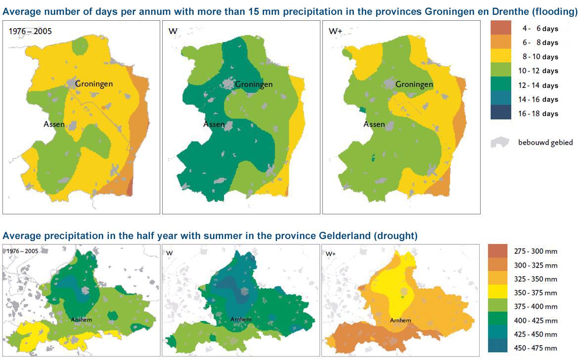
In particular, conditions that are either too wet or too dry have a negative effect on agricultural crop yield. IPO has produced map images of such climate change patterns (see examples below). For the potential precipitation surplus (rainfall minus reference crop evaporation) W and W+ are respectively the wettest and the driest of the four scenarios.
To calculate the effects of climate change on agricultural yield requires meteorological data on the whole year, preferably on a daily basis. KNMI has developed tools that make it possible to transform a time series based on daily rainfall, reference evaporation and temperature of a random measuring station to a future climate. This transformation not only takes into account the changes in the amount of precipitation, but also the changes in the intensity distribution of rainfall and shift changes in the precipitation distribution across the seasons.
Using the same method, KNMI developed tools for the National Model and Data Centre [Nationaal Modellen en Data Centrum] (NMDC) for gathering data in relation to radiation, humidity, wind speed and temperature so that National Hydrological Tool (NHI)[Nationaal Hydrologisch Instrumentarium] is able to calculate the actual evaporation in accordance with the Penman- Monteith method. In this way, it is possible to make comparisons between crop growth, evaporation, and resulting groundwater supplement in a changing climate. Nowadays, the KNMI also has a better insight into regional differences of climate change in the Netherlands. Forecasts for changes in precipitation patterns for coastal areas are different to forecasts for the interior. In the tools to be developed for transforming the climate series, this spatial differentiation will be included.
Crop yield
Crop yield and limiting factors
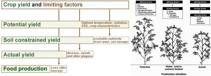
Climate effects on agriculture are usually visible in the crop yield. Distinction is made between potential and actual yield and sometimes, in the harvestable product. The figure below provides a schematic overview. The factors that are impacted by climate change are underlined in the figure on the left.
The potential yield is the optimal yield that can be realized in a particular climate in terms of CO2-concentration, radiation and temperature, the characteristics of the crop concerned and the optimal provision of water and nutrients. The actual yield is lower because: a) availability of water and nutrients are never optimal and salt or other polluting substances cause damage and b) growth is limited by disease, weeds or plagues. The potential yield can be increased by improving the varietal purity (plant breeding) and by adjusting the sowing date. The difference between the potential and actual yield can be decreased by means of using (chemical) fertilizer, insecticide, crop rotation, irrigation, mechanization, other technological improvements and crop management.
Yield depression due to drought and flood
Agricultural crops produce biomass from water, CO2 and nutrients with energy and sunlight. In practice, every effort is made to optimize conditions for this production in order for the plants to achieve maximum growth. If this process is impeded due to sub-optimal water supply, it creates a growth delay resulting in a yield depression. This depression could be due to conditions being too dry or too wet. Dry conditions lead to insufficient water supply and reduced photosynthesis, which immediately reduces crop growth. Soil that is too dry in the spring can result in delayed germination of the sowing seed and a poor development of the planted crops. Conditions that are too wet result in insufficient oxygen for the crop. If there is insufficient gas exchange (oxygen and CO2) between the soil and the atmosphere, the roots can no longer function properly and can even die. It can also lead to nitrogen deficiency. Conditions that are too wet also result in indirect damage, as the load bearing capacity of the wet soil is insufficient for grazing and for the use of agricultural machinery required in cultivation.
Calculation methods crop yields
In the Netherlands, a number of calculation methods are used for calculating crop yields as function of hydrological and weather conditions.
- HELP-tables: 1st version 1987 (Work group HELP-table, 1987), last update HELP-2006 (van Bakel, 2007)
- AGRICOM: 1st version: Wl/Delft 1995, updates 2009-2010, last update 2014 (Mulder and Veldhuizen, 2014)
- TCGB-tables Technicshe Commissie Grondwater Beheer, update 1990 (Bouwmans, 1990)
- WaterWijzer Landbouw, a replacement for these out-dated methods, is currently under construction (see www.waterwijzer.nl).
Below is a brief description of these calculation methods.
HELP-2006 tables
The HELP-tables were created to ascertain the effects of water management works on the agricultural crop yield, for the benefit of evaluating spatial development projects (Work group HELP-table, 1987). Based on soil maps and maps of groundwater level changes for grassland and arable land, the tables provide long standing averages on yield depressions owing to moisture shortage or moisture excess. The depressions on moisture shortages are determined based on modelling the moisture conditions in the unsaturated zone (model LAMOS). The moisture shortages calculated with this model are related to the yield loss due to drought. The estimated depressions due to excess water are based on practical insights and trial field research. It contains the direct and indirect yield depressions. The tables do not take business economic aspects or business management into account.
The HELP-tables from 1987 were augmented in 2006; more crops and soil types were added and made semi-continuous for the Waternood-instrumenatrium. These tables, known as the HELP-2006 tables are available as a G IS application to help determine the agricultural target realization for current or for changing hydrological conditions. The HELP-tables support the stipulation on the Desired Ground and Surface Water Regime (GGOR) [Gewenste Grond en Oppervlaktewater Regiem]. In the report on the HELP-2006 tables (STOWA, 2007), yield reduction was defined as a first-order damage effect and expert judgment was used to set compensation amounts per percentage of yield reduction, per groups of crops or crop distinguished.
There are several reasons why the tables are not suitable for calculating the effects of climate change (van Bakel, 2011) but in particular, because the tables are based on old, non-reproducible calculations on weather data from 1950-1980.
AGRICOM
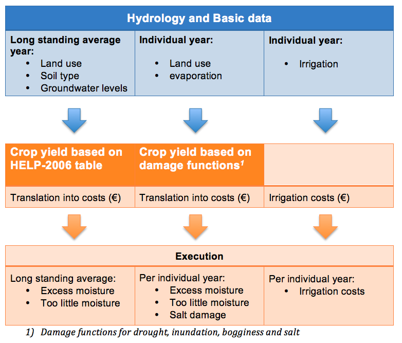
AGRICOM, an acronym for AGRIcultural COst Model, is an agro-economic model that calculates costs and benefits for the agricultural sector in the Netherlands, based on the results of a hydrological model (Mulder and Veldhuizen, 2014). It concerns the effects of conditions being too dry, too wet and too saline on Dutch land-based agriculture. It is used for national exploration of fresh water supply. It is linked to the het NHI (Nederlands Hydrologisch Instrumentarium) and it uses the following data: groundwater levels, potential and actual evaporation, irrigation with ground and surface water, salt concentrations in soil moisture and/or irrigation water, land use and soil type.
The model calculations start in hydrology, crop yields for individual years based on derived damage functions for drought, inundation, bogginess (wet ground) and salt. Damage due to drought and bogginess is calculated as a function of the ratio between actual and potential evaporation.
AGRICOM is an acronym for AGRIcultural COst Model. AGRICOM, based on the results of a hydrological model, is an agro-economic model that calculates costs and benefits for the agricultural sector in the Netherlands. It concerns the effects of conditions being too dry, too wet and too saline in Dutch agriculture. The cost and benefit analysis is executed per year or the average of a long-term period. The AGRICOM model serves to support policy questions such as: what are likely measures to prevent agricultural damage, what are the agricultural side-effects resulting from the anti-dehydration measures implemented for nature areas and how efficient is the irrigation?
AGRICOM also calculates the yield changes for a long-standing situations based on the HELP-2006 tables. For the same reasons as stated with the HELP-tables, AGRICOM is unsuitable for calculating the effects of climate change. For drought damage, this can be neutralized by calculating the crop yield with the crop growth model.
TCGB-tables
The Technical Committee Groundwater Management [Technische Commissie Grondwater Beheer] (at present ACSG) formulated tables to compensate farmers for crop damage that occurs due to groundwater extraction. Just like in the HELP-tables, the TCGB-tables distinguish between moisture damage and dry damage. The drought damage is derived from the moisture shortage that is calculated with the MUST model. Some parts of this model are different to the LAMOS model, which was used for the HELP-tables, but the models are largely comparable. This model was used to derive depression tables, which are used to ascertain the depression for grassland on sandy soil for an individual year, based on a combination of GVG-GLG data. For the same reasons as previously stated with the HELP-tables, the TCGB-tables are unsuitable for forecasting the impact of climate change on agriculture.
WaterWijzer Landbouw
Water managers, the agricultural sector, water supply companies and other users of the abovementioned methods have insisted for quite some time that these methods ought to be revised. 2012 saw the start of an extensive project that will lead to a new, practical method for calculating agricultural yield with dependencies on water management conditions. The new method has to be reproducible and updatable as well as climate-proof. The name of this project is WaterWijzer Landbouw. Based on existing knowledge, the first model that was completed is an operational version of SWAP, which calculates damages related to conditions being too dry, too wet and too saline. (Bartholomeus et al., 2013). Example calculations show that a) long-standing averages can be ascertained, b) annual averages can be calculated for separate years, so that the differences between separate years are apparent and c) for extreme weather conditions in a particular year. Last but not least, d) calculations for weather scenarios. In this version, water damage (root and soil problems) is a function of oxygen stress and therefore based on process knowledge.
Based on the first results and trials (Hack-ten Broeke et al., 2013) it was decided to continue with further development of WaterWijzer Landbouw. This means that a link is made with the crop growth model WOFOST so that the potential and actual crop yields can be calculated as well as the yield loss due to water management conditions. The first usable experiences with regard to the connected models SWAP and WOFOST were published by Kroes and Supit (2011) for grassland.
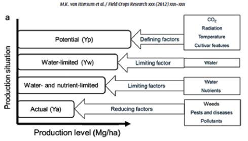
In WOFOST, crop growth is calculated as a function of CO2 content in the air, solar radiation, temperature, and crop characteristics. The availability of water determines the limitation on crop production. The figure below provides a schematic overview of the yield calculations in the WOFOST model (Van Ittersum et al., 2012)
In addition to the link with crop growth modelling, WaterWijzer Landbouw intends to quantify the direct and indirect effects of dry, wet and saline damage. Possible indirect effects are effects due to poor cultivation workability (in sowing and harvesting), insufficient load bearing ability for grazing or harvesting, crop die-off, increased weed pressure, structure putrefaction or increased disease and plagues. The WaterWijzer Landbouw will be available in 2016 at the earliest.
Climate effects agricultural crops
For the Knowledge for Climate (KvK) [Kennis voor Klimaat] programme, Wageningen UR (Stoorvogel) made an inventory of the existing knowledge relating to climate effects on agriculture (2009). In broad strokes, the following conclusions were drawn:
- The expected climate changes related to the temperature and the increase in de CO2 concentration are having a positive effect on crop production in Europe.
- These effects differ per crop and per agricultural system.
- Arable farming in the Netherlands is rather vulnerable with regard to the expected increase of uncertainty in weather conditions with the accompanying (extremely) dry and wet periods and extreme temperatures, the problems that coincide with increasing salinity and the expected increase of disease and plagues.
- The probability increases of insufficient fresh water supply, via the main water system, to the polders (reclaimed land) that are vulnerable with regard to salinity. In areas of intensive horticulture, the financial damage could turn out to be considerable.
- Effects of climate change on disease and plagues are more difficult to predict than crop growth, but observations from the past do confirm that the expected damage is increasing. For example, increased pressure from vermin (pests) and disease owing to higher temperatures were already observed in the relatively warm period 1989-2004.
- Various changes have a compounded effect on each other. For instance, the effect of increased CO2 concentrations is transportation reduction, which in turn, can have a moderating effect on the moisture shortages during drought and have a boosting effect on damage due to excess moisture.
An increase in temperature and CO2 concentration in the air has a favourable effect on agricultural production in the Netherlands, such as grassland for instance. In the G+ and W+ scenarios, this favourable effect is (partly) undone by the increased probability of a water shortage in summer (10%-drought-year increase of approximately 100 mm, Van der Gaast et al., 2009).
This can lead to lower production, especially on soil with a higher sand content. These two scenarios also have extra wet winters, which will have an effect on grasslands in the lower parts of the Netherlands, where it will be boggier, which will make grazing and harvesting more difficult. Table 1, taken from a recent study into climate effects on agriculture and nature on rural sandy soils, provides an overview of the impact of climate change on soils that have a higher sand content (Geertsema, 2011).
| Climate aspect | Effect | Consequences for agriculture |
| Changes in temperature patterns | Temperature increase | Production increase, extended growing season, introduction of water-loving crops |
| Increase in disease and plagues by: • introduction of new species • increased reproduction and curtailment of regeneration cycle • breaking down crop resistance | ||
| Diseases and plagues can survive through winter | ||
| Emergence of invasive plant varieties | ||
| Insufficient vernalization. Vernalization is the process of influencing the growth process/ growth stage by exposure to cold. Generally takes place at temperatures between 0 and 10° C and for best results, between 0 and 3 degrees. | ||
| Frost | Flower(buds) freezing to death during early growth | |
| Heat waves | Product loss, crop damage. Lower milk production at dairy farms, more power required for ventilation of stables, more odour problems due to more intensive livestock farming | |
| Changes in precipitation patterns | Flooding | Loss of quality due to long-term water submersion (anaerobic) |
| Harvesting machines cannot drive onto the fields | ||
| Increase in disease and plagues | ||
| Delays in sowing dates | ||
| Drought | Yield loss | |
| Quality changes (osmosis effects) especially in corn/maize, grains and cereals, potatoes. Sugar beet has higher sugar content. | ||
| Heavy showers or hail | Physical damage, particularly in horticulture and (tree) nursery stock | |
| Flattening (cereal, grain, corn) | ||
| CO2 increase | Production increase (by stimulation of vegetative growth of crops) |
Table 1. Consequences of climate change on agriculture and soil with a higher sand content (Source: Geertsema et al., 2011).
In another research project for Knowledge for Climate [A21 Hotspot Climate and Agriculture in Northern Netherlands] the Agro-climate calendar was developed (Schaap, 2011). The objective of this project is to get a more concrete look, together with stakeholders, at the different climate factors that have an impact on the quality and yield of different crops and which of these pose a future risk. Based on this, a specific set of adaptation measures can be formulated and discussed with the various stakeholders.
To make an assessment of the impact of climate change, the climate data and specific factors are compared per crop for each time frame. All climate factors do not have an equally solid base in science. Some threshold values can be found in literature, others are based on expert knowledge and practical field knowledge. The different sources are provided without any value judgements. The agro-climate calendar provides 1) the frequency of damage caused by climate factors for a crop in the current climate at a specific location and 2) the expected shift in the frequency of damage causing climate factors. An example of the results is provided in table 2.
In essence, the Agro-climate calendar is a simple concept that can be used by almost anybody. The tool does require a certain input from the user. Firstly, aside from crop knowledge and cultivation knowledge, climate data is required in order to characterise the climate factors. The KNMI’06-scenarios can subsequently be used to calculate how the frequency of climate factors changes in the future.
| Climate factor | Period | Impact on crop | Extent of the estimated yield loss (%) |
| Heavy rainfall | May - Sept. | Putrefaction of a substantial part of the potato crop. | 25 - 75 |
| Heat wave | July – Sept. | The process where sprouting is aborted or disturbed. | 25 - 75 |
| Warm and wet | July – Sept. | Increasing appearance of Erwinia (blackleg), a bacterial disease that causes tuber decay and aerial stem rot, resulting in yield loss. | 10 – 50 |
| Persistent wet weather | June –Sept. | Spraying against Phytophthora is impossible (causes disease spread) so the crop is lost. | 50 - 100 |
| Warm winter | Dec. - March | Storing potatoes is problematic; the open air cannot cool the potatoes sufficiently and causes moisture loss, shoot sprouting and rot. (This is disastrous for seed potatoes). | 25 - 75 |
Table 2. Climate effects on potato (Source: Agroclimatecalendar WUR).
Table 2 was formulated for all fifteen crops investigated (De Wit et al., 2009, Schaap et al., 2009). The website http://www.klimaatenlandbouw.wur.nl only shows these tables for potatoes, wheat and sugar beet.
Expectations are that the structural effects of climate change on agriculture will be limited for the time being. In the short term, the expected technological innovations and adjustments in agricultural management will, for the larger part, be able to deal with the gradual climate change. Even so, agriculture will have to take advantage of unexpected conditions. Important knowledge gaps exist, particularly owing to the changing risks brought about by extremes and the effects of persistent wet or dry periods on disease and plagues.
Climate change also intensifies the environmental impact of fertilizer and pollution in agriculture. For instance, heavy precipitation will cause shallower runoff of nutrients and crop protection products into the surface waters. This effect is relevant in relation to reaching the objectives set in the EU Framework Directive Water [Kaderrichtlijn Water]. In a general sense, such effects were calculated by Alterra Wageningen UR in a research project executed within the framework of the LNV Policy Support Research Programme Water / cluster Vital Rural Area (Gerven et al., concept rapport 2011).
Climate change, in particular temperature increase, could also lead to a more rapid decomposition of organic matter in the soil that will result in a quality decrease in humus and reduce the water retaining capacity of the soil. This topic is addressed in the Delta Fact 'Soil as a buffer'.
The use of crop models in climate studies often start with the premise that climate has the primary impact on crop yield and that climate change is the only change. Potential yields can be increased by improving varietal purity in plant breeding and by adjusting the sowing date. The difference between potential and actual yield can be decreased by using (artificial) fertilizer, pesticides, irrigation and management changes directed at preventing yield loss. Therefore, it is important that current agricultural business management is mapped so that future forecasts are also possible in this regard.
Adaptation possibilities for agriculture
To take advantage of changing weather conditions and limit the emission of hothouse gasses CO2 and N2O, the agricultural sector will have to take adaptation measures just the same as other sectors will have to take measures. Doing nothing for the long-term is not an option. Measures can be taken on several levels, varying from plot or crop level to regional scale levels:
- Crop level: adjustments in relation to crop growth, taking advantage of the changing growth conditions like soil structure and water management.
- Business level: management adaptation, for example, changes in annual planning and crop rotation.
- Sector level adaptation of business processes with innovative measures such as introducing new crops or new cultivation systems.
- Area level: integral approach on cross-sectoral effects, ensuring that measures taken match up with policy measures in other sectors such as nature and water et cetera.
Given the close inter-relatedness of sectors in the same area, 'cross-sectoral effects' are understood to mean that adaptation strategies should be approached with the intention of matching the measures taken in other sectors in the same area. A scale level approach offers a framework of measures to be taken. The reasoning behind the consequences of cultivation adjustments for a business, for other sectors or for the region as a whole can take place from both the lower to the higher scale level. The same applies to the other way around. What are the consequences of future market developments or of adjustments to the water system for the different farming sectors and other sectors, for separate businesses or for specific production? This kind of approach indicates that sectoral measures cannot be seen as separate and have to be viewed as part of the larger whole and as part of the measures that are taken in other sectors.
Knowledge has been gathered on adapting agricultural practice to climate change in several different projects:
- Climate and arable farming in Northern Netherlands: a practically oriented project in cooperation with LTO and Grontmij, among others, in which the effects of climate extremes and adaptation strategies are discussed with farmers and other stakeholders.
- Agri-Adapt: a scientific project by Climate changes for Spatial Planning [Klimaat voor Ruimte] focussed on researching the impact of climate change on agriculture on different scale levels; in addition to crops, also on business, regions and the European Union.
- Climate Adaptation for Rural Areas: a scientific project by the Chamber of Commerce, investigating the adaptation to climate change in rural areas; changes in climate, land use, hydrology, nature and agriculture were linked and cross-sectoral adaptation strategies evaluated.
- Climate Projections: a scientific project by the Chamber of Commerce that provides high-quality information about climate change and the effects of climate change, with the objective of facilitating the development of both national and regional adaptation strategies.
For the most part, the knowledge gathered is bundled and made available on the climate and agriculture website www.klimaatenlandbouw.nl previously mentioned with regard to the Agro-Climate Calendar available on the same website. Table 3, taken from this calendar, provides possible adaptation strategies for winter wheat to mitigate or prevent damage due to climate risks.
| Level | Indicative costs | Indicative costs | |
| Persistent drought – yield loss (June – Aug.) | Annual (k€/ha) | Investment (k€/ha) | |
| Increasing moisture retention and moisture storing capacity of the soil 1) | Business | 0.1 – 0.5 | - |
| Developing a drought resistant variety | Sector | - | 1,000-10,000*) |
| Unstable weather – freezing of roots (Nov. – March) | |||
| Sowing earlier | Crop/ business | nil |
1.)for possible (effects of) measures, see appendix 4 of de Wit et al. (2009)
*) costs cannot be provided per hectare
Table 3. Possible adaptation measures for the cultivation of winter wheat, to prevent or mitigate damage for the target year 2040 due to climate risks (persistent drought, unstable weather). Source: www.klimaatenlandbouw.wur.nl
The website of climate and agriculture also shows these tables for sugar beet and table potatoes. For other crops, the tables can be found in the stated literature (Wit et al 2009, Schaap et al 2011).
Governance
Climate change can have substantial consequences for agriculture, not only with regard to changing conditions for crops but also in relation to disease and plagues, the need for different crops such as energy crops, up to business management risks such as harvest security and business reliability, for example in relation to energy supply. Climate change also offers opportunities, for instance raising crops that thrive in a warmer climate or being able to sow earlier in spring because there is less frost.
At present, decisions are being made in the agricultural sector based on trends in the market and on policy. Even though climate change is an additional stress, it is not taken into account when important decisions are made such as whether to continue or expand a business. There is a danger of incorrect or delayed decision-making and investments with possibly dangerous or fatal consequences that could be perpetuated in the processing and supply industries.
Adaptation is not only a task for the agricultural companies but a collective assignment for various parties. Governance refers to the way in which authorities – together with other parties that have an interest - develop adaptive capacities (van Buuren et al., 2009). In Knowledge for Climate, ample attention is paid to the aspects of adaptation under the topic of Governance of Adaptation.
It is important that farmers anticipate climate changes and take it into account in their business management, expansion and investment plans. For government, it is important to formulate policies for adaptation as such that it creates new opportunities for spatial development and water management in order to ensure that the position of agriculture is secured in the long-term.
Knowledge gaps
The currently used HELP-tables and TCG B-tables as well as AGRICOM are unsuitable for the purpose of forecasting the effects of climate change on crop growth. As previously indicated, work is in progress with regard to developing a new methodology to replace the out-dated methods. The new methodology is based on the simulation models SWAP and WOFOST.
Uncertainties about the developments in crop yield depend on the processes containing the factors that impact crop yields:
- Climate change Technological development
- The so-called 'yield gap', the difference between the potential yield and the actual yield, determined by technology and management.
Climate change
The KNMI concludes that the climate scenarios calculated in 2006 have not been out-dated by recent developments in science. According to current insights, the combined descriptions of the four KNMI’06-scenarios still provide the most likely outcome of climate changes in the Netherlands, with accompanying uncertainties. New insights do indicate that the W/W+-scenarios best describe the rapid warming in the Netherlands and Western Europe. The increased intensity of heavy rainfall is well rendered in the G/W-scenarios. In addition to possible persistent periods of drought, like in the G+/W+-scenarios, the coastal zone will probably have more frequent periods of wetter weather, as shown in the G/W- scenarios. KNMI will formulate new climate scenarios in 2013. Insights described above and possible new insights, including spatial differentiation, will be included in the new scenarios.
Technological developments
There are many active discussions about technological developments. There are scientists who expect that genetic development of crops will not increase the yield by much but there are also scientists who expect that the developments as started after World War II will continue. One thing that we are sure of is that genetic development has played a much larger role than climate change during the past 50 years. The rapid increase in crop yield in the last 50 years can largely be attributed to crop management. The increased use of (artificial) fertilizer, pesticides, herbicides and insecticides as well as scale increase and mechanization has resulted in improved efficiency.
Yield-gap: difference between potential and actual crop yields
Research, undertaken to further develop and validate the modelling tools in SWAP-WOFOST, has shown that there is insufficient data of adequate quality available from Dutch field experiments that can be used to evaluate the calculated potential and actual crop yields of the model against actual results achieved in the field. In particular, there is a lack of experiments in which both the crop yields and the water management in the unsaturated soil zone was measured through the course of time.
Overview of currently active research projects
Knowledge for Climate
The research for the Knowledge for Climate program is subdivided into eight hotspots and eight themes. Specific research into climate effects on agriculture and adaptation to this takes place in the hotspots ‘south-west delta’, ‘shallow waters and peat meadow areas’, ‘dry rural areas’ and in the research theme ‘climate adaptation for rural areas’:
| Hotspots & themes | Projects / work packages |
| South-West Netherlands Delta | Negotiating uncertainties: defining climate proofing and assessing associated uncertainties in the southwest Delta Region of the Netherlands |
| Climate change effects on restoration of estuarine dynamics within the Delta region | |
| Climate change as an opportunity for entrepreneurs | |
| Exploring fresh water supplies southwest Delta | |
| Shallow waters and peat meadow areas | Climate effects on decomposition in drained peat meadow |
| Climate influence on water quality: which trends are already apparent? | |
| Managing climate effects in peat meadows and shallow lakes | |
| Dry rural areas | An inventory of strategies to cope with climate change in dry rural sandy areas with a temperate climate: a case study in the Province of Gelderland |
| Combining spatial claims of land use functions and adaptive strategies to climate change in densely populated rural areas | |
| Climate Adaptation for Rural Areas | WP1: Integration: multifunctional adaptation to climate change (pdf) |
| WP2: Water and biodiversity in the future climate (pdf) | |
| WP3: Drivers and consequences of adaptation by farmers (pdf) |
Climate for spatial planning
The research programme Climate for Spatial Planning was completed in 2011. The programme comprised of five themes: ‘Climate scenarios’, ‘mitigation’, ‘adaptation’, ‘integration’ and ‘communication’. The research that specifically relates to agriculture are:
How can agriculture adapt to changes of both climate and market; NL-North as a pilot region – A12
Based on literature, this desktop research looked into the effects of climate change and market developments in European agriculture. The impact was estimated for two ‘climate market development scenarios’ for potato, grain and dairy production. This research is the point of departure for phase 2 of the Climate for Spatial Planning Research-A21.
Climate and Agriculture in Northern Netherlands – A21.
In phase 2 of this project (phase 1 relates to A12) the impact of climate extremes is researched on 15 different crops in the present situation, in 2040 and in 2100. In phase 3, the agricultural situation is researched in greater detail in various areas. During adaptation workshops the results of the research was discussed and reviewed with stakeholders in the area. The Agroclimatecalendar is a development from this project. This is a method and tool that is relatively easy to use for estimating the damage caused by different climate factors – extreme weather conditions and disease and plagues – to crops and how these climate risks shift with climate change. The Agro-climate calendar can:
- Show fairly simple images of the climate factors that carry the most risk for causing damage to crops grown in the current climate, by providing a monthly frequency overview of the most damaging climate factors. For instance, extreme whether conditions, diseases and plagues are fairly easy to map in this way. This is a substantial advantage as current crop models are unable to take climate factors into account in any significant way.
- Show how the risk frequencies shift in a changing climate.
- Assess the most relevant future risks that climate factors pose to crops.
Hotspot Groningen - A18
In the hotspot climate-proof Groningen, the knowledge gained is applied to spatial planning on the scale of provincial level. The results of the project offer other authorities lines of approach to climate-proof their regional planning and the results can be used in formulating environmental plans, structural concepts, water management plans by provincial authorities, water boards and local authorities.
Assessing the adaptive capacity of Agriculture in the Netherlands to the impacts of climate change under different market and policy scenarios - A19
This research relates to the risks of climate effects and, based on a model (WOFOST), the impact on agricultural production in Flevoland was evaluated in an iterative process (workshops) with farmers and robust adaptation measures were defined. The costs and benefits of the adaptation measures were also taken into account and no-regret measures that can now be taken were identified.
NMDC-innovation project Integral Water Management, Critical Zone
This NMDC-innovation project, a cooperation between the National Model and Data Centre and the knowledge institutes Wageningen UR, TNO, Deltares, PBL and the KNMI in order to adjust and create better links between the models for water management and make them suitable for climate effect simulation. In two pilot areas, Walcheren and the Baakse Beek, models for hydrology, nature and agriculture were set up and linked to each other (Van Ek, 2012; Schipper et al., 2013).