 English resume
Critical infrastructure
Infrastructure networks are critical assets for the continuity of vital societal functions. The term critical infrastructure is commonly associated with facilities such as the electricity grid, (tele)communication, transport, gas and water management.
|
Thema |
Ruimtelijke adaptatie, Delta facts, English versions |
|
Tags |
|
|
Downloads |
- INTRODUCTION
- RELATED TOPICS AND DELTA FACTS
- MULTILAYER SAFETY STRATEGY
- SCHEMATIC
- POSITIONING
- GOVERNANCE
- COSTS AND BENEFITS
- LESSONS LEARNED AND ON-GOING STUDY
- KNOWLEDGE GAPS
- EXPERIENCES
Introduction
Infrastructure networks are critical assets for the continuity of vital societal functions. The term critical infrastructure is commonly associated with facilities such as the electricity grid, (tele)communication, transport, gas and water management (source FloodProbe).
In light of this, any assessment of flood risk must consider critical infrastructure, as (Heilmann et al, 2012):
- The functioning of critical infrastructure is crucial to the functioning of an area, given that (temporary) failure has the potential to cause social disruption (casualties/economic loss/recovery or independence). Critical infrastructure needs to be recovered before other functions can become operational.
- Failure of critical infrastructure in flooded areas can lead to failure in non-flooded areas and subsequently to spreading the adverse consequences of the flood.
- The indirect damage from failure of critical infrastructure can be significant (many times greater than the indirect damage itself).
- Critical infrastructure is instrumental to disaster management and, as such, its vulnerabilities must be thoroughly addressed in emergency management plans.
The key to making critical infrastructures resilient to flooding is through correct positioning (location choice) and design. In this Delta Fact the focus is placed on the following types of critical infrastructure:
- road and waterway network (transport sector): motorways, railways
- water supply and sewerage system (drinking water sector)
- electricity (energy sector): high-voltage power lines and power plants
- communications services (telecommunications sector)
- vulnerable facilities
For more information about the critical sectors and critical services and products, see Information on Critical Sectors (Ministry of the Interior and Kingdom Relations, 2010).
Protection of critical infrastructure can be addressed within spatial planning processes, and is the responsibility of local and provincial authorities. The water boards do not have a formal role in these processes. Critical infrastructure protection is not provided for within the Spatial Planning Policy. At present, extensive studies are underway to evaluate the vulnerability of critical infrastructure in flood events.
Related topics and Delta Facts
Keywords: (Urban) flood management, Floods Directive, flood maps and risks, water assessment, recovery
Delta facts: Spatial development in and on flood defences, Floods Directive.
Multilayer safety strategy
Within the multilayer safety strategy, critical infrastructure falls under:
1 Prevention, 2 Spatial Planning, 3 Crisis Management
This topic can be approached from the second and third layer. The second and third layers are aimed at mitigating the consequences of flood events. The second layer involves the realisation of sustainable spatial development in the Netherlands, while the third layer is oriented to improved organisational preparation for possible flood (disaster management) (NWP, 2009). Protection of critical infrastructure can be regarded as a measure for spatial planning and is part of crisis management.
Schematic
The figure below, which is taken from the "Roadmap Towards Flood-Resilient Development" of the province of Utrecht (Luyendijk et al., 2010), outlines the process for dealing with floods:
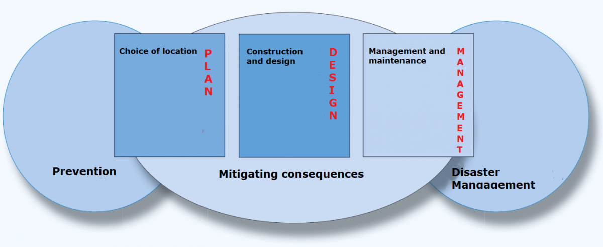
Source: Luyendijk et al. (2010)
A number of pillars are distinguished for mitigating consequences by making choices in spatial planning:
- Location
- Design/development/construction
- management and maintenance
In this respect, flood characteristics such as water depth, water pressure, frequency, flow velocities and arrival time provide useful information with regard to determining a suitable location (Luyendijk et al., 2010). Specifically where positioning is concerned, the water board can provide important information based on analysis of areas at risk of being flooded, the flood depth and flood probability (see experience Water-Resilient City).
The table below provides an overview of the different sectors where critical infrastructure may be located and the types of measures that could be considered.
| Sector | Critical infrastructure | Possible design/layout measures |
| Roads and waterways (transport) | National highways | Build on higher ground |
| Provincial roads | Build with flood-resilient materials that can withstand extreme weather conditions and facilitate preventive evacuation and emergency response. | |
| Railways and stations | ||
| Pumping stations | ||
| Locks and sluices | ||
| Ports | ||
| Lighthouses | ||
| Drinking water | Drinking water wells and pump stations | High location |
| Pumps and pumping stations | Adapted design | |
| Drainage facilities | ||
| Energy | Power plants | Surround with protective dikes |
| Electricity distribution substations (high, medium and low voltage) | Assess flood risks before construction | |
| Local power plants (including cogeneration plants) | ||
| Gas measuring and control stations | ||
| Nuclear reactor (including medical) | ||
| Telecommunications sector | Emergency reserve power plant | Construction of radio masts and towers not prone to flood damage |
| ICT centres | Flexible operating network | |
| Regional emergency alert radio station | ||
| Vulnerable facilities (vulnerable facilities are not always categorised as critical infrastructure) | Hospitals | Ring dikes |
| Chemicals industry | Adapt designs and layout | |
| Water purification | Mounds | |
| (chemical) industry | Cellular cofferdams | |
| Small-scale compartmentalisation | ||
| Temporary inflatable dams | ||
| Difference in floor and street level | ||
| Ground level elevation | ||
| Water-fillable barriers |
The table is based partly on the information provided in “Roadmap Towards Flood-Resilient Development” (Luyendijk et al., 2010)
The selection of measures can be based on practical considerations, such as:
- Keeping the water literally at bay (elevating the quay/building a roof).
- Reducing damage.
- Ensuring a speedy recovery effort.
- Providing adjustment opportunities in the management phase
(Luyendijk et al., 2010, p. 23).
There are various checklists relating to the protection of critical infrastructure in spatial planning. The study undertaken by the province of Utrecht proposes a set of physical measures, i.e. hard (technical) and soft (communication or organisational) measures, which can also be taken.
Positioning
Raising awareness
The facilities/areas at risk of flooding can be identified through a system analysis. The information obtained from this analysis should then be made available to raise awareness among the public of the flood risks and of the preventive measures that can be taken to reduce them.
The area pilot study, Water-Resilient City (Koeze & van Drimmelen, 2011), has developed a risk zoning map (see figure below). According to the map, there are a number of vulnerable facilities in areas at risk of significant damage from flood events. An example is the computer centre in Science Park which is located at -6 m NAP. This was not taken into consideration during the spatial planning process. Another example is the AMC hospital. Flood events can have dire consequences for certain vulnerable facilities (e.g. the AMC hospital), which must factor heavily in the construction process. This requires a different approach to thinking about spatial planning. The water board is the knowledge carrier of water safety and must apply this knowledge in the spatial planning process, addressing such location-specific questions as: how fast will the water rise? What is the flow velocity? What is the maximum depth? (these knowledge questions require knowledge-based answers).
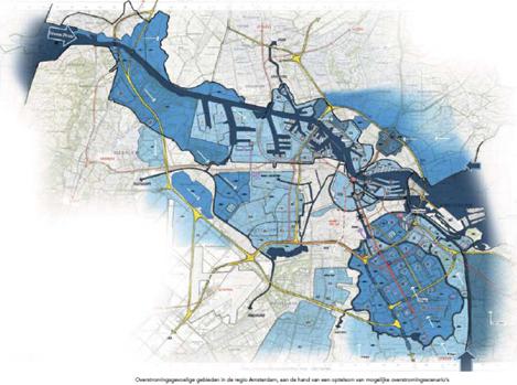
Flood-prone areas in the Amsterdam region based on the sum of potential flooding scenarios (Koeze & van Drimmelen, 2011).
Perhaps the flood risk maps could serve as input in the development of a risk zoning map similar to the map used in the Water-Resilient City project.
Protection
The general framework for protection will be formulated in the general framework for disaster management. As a strict rule, measures must be in place before an emergency situation arises. Protection may consist of various elements, namely:
- layer 1: identifying critical infrastructure (positioning) development measures
- layer 2: physical technical (hard) measures such as elevation
- layer 3: non-technical governance and regulatory (soft) measures (e.g. training exercises, plans such as FIMFRAME)
It is also important to put in place the preventive measures outlined in the second layer. Critical infrastructure protection, however, is not adequately addressed in the spatial planning policy/legislation. An example is the expansion of the A2 where water safety is not included in either the design or the implementation. But protection could be addressed in the Water Assessment, even though the recommendations are not binding.
The second layer also includes compartmentalisation. Critical infrastructure can also play a role here by elevating the pathways, particularly as a means of protecting vulnerable facilities such as hospitals and the fire brigade, which are likely to sustain damage from floods (see raising awareness, above).
Protection also involves thinking about critical infrastructure and ensuring that it will be able to withstand a flood event or ensuring that everyone understands their responsibilities, i.e. the order in which the designated response teams will implement the measures. The foregoing information and the information provided below will be outlined in the emergency management plans:
- everyone knows what to do
- everything is well-documented
- training exercises are held regularly
An assessment tool for determining whether critical infrastructure is adequately addressed in these emergency management plans has been developed as part of FIMFRAME. This issue is discussed only very briefly in existing regional plans due to the fact that the entire concept of critical infrastructure protection is still developing.
Governance
Legal framework
There is currently no legal framework for integrating critical infrastructure in spatial planning. The multilayer safety concept, particularly the second layer, requires a different approach to water safety within spatial planning and the role of critical infrastructure therein. Responsibilities and liabilities are currently addressed in the first layer. There is also little knowledge available regarding the governance structures of the second and third layer. The Water Assessment could serve as an effective instrument for integrating critical infrastructure in spatial planning, although on a somewhat non-binding basis.
National policy for evacuation routes
Evacuation routes are currently subject to regional policy. This could create bottlenecks during evacuation if the same escape route were to be used by two neighbouring regions, as observed in the area pilot project the Water-Resilient City, which, in this case, is the A2. To avoid this 'potential' problem, it is recommended that a national policy for evacuation routes be developed, addressing the following questions:
- how fast can people be evacuated?
- are there areas in which elevated roads can be built?
- is it possible to change traffic flow on motorways (all one-way instead of two-way traffic)?
- sufficient number of safe places/shelters in an area itself
This requires good information flow and communication with the emergency services. Critical infrastructure is in place to support evacuation efforts and emergency services.
Other governance aspects
- Incorporating the role of water boards within spatial planning processes.
- Financial, economic: consideration of measures between layers is important (which measure is socially efficient and effective), in other words, would you opt for prevention with dikes, or would you also invest in the infrastructure?
- Legal: Incorporating infrastructural measures in legislation (spatial reservations?). This can be done via the Keur (defining roads as dry watercourses) and via the Structuurvisie Infrastructuur en Ruimte (SVIR - National Policy Strategy for Infrastructure and Spatial Planning) and the AMvB Ruimte (Order in Council Spatial Planning).
- Administrative: how can you reach effective agreements among the parties in the three layers, which in fact represent three sectors: Water, Spatial Planning and Internal Affairs (Public Order and Safety and Public Administration; coordinating minister for crisis management; coordinating responsibility for critical infrastructure protection)? What are the responsibilities of each party, which party bears which costs and how can you ensure that the agreements will continue to be relevant and responsive to future challenges?
- Communication with the public: What do our times call for, how do you keep the issue relevant and which party will ensure that this communication takes place?
Within the National Delta Programme for New Construction and Restructuring, a Study is currently underway on flood risk zoning behind dikes which addresses these themes.
Costs and benefits
| Benefits | Costs |
| less damage after flood events | land-based measures in existing spatial planning often not feasible in terms of costs |
| faster recovery after flood events | |
| residential and commercial development on new floodplains | |
| reduced risk of the indirect consequences of flood damage spreading to other areas |
Lessons learned and on-going study
Currently, a rigorous process is underway to identify the critical infrastructure assets in the Netherlands. After this is completed, another process will be undertaken to determine how they can effectively be embedded in zoning plans.
On-going study:
Investigation of the blue spots in the Netherlands National Highway Network
Deltares is currently conducting a study for the Transport and Navigation Department on the vulnerability of national roads to flood events and climate change. Flood events will be assessed at three levels: (1) flooding from open watercourses (rivers, lakes, sea), (2) road inundation due to waterlogged conditions caused by prolonged and heavy rainfall and (3) inundation of the road infrastructure itself as a result of heavy rainfall. The aim is to identify the blue spots in the national road network in terms of the current situation and the forecast for 2050.
FLoodProBE
Floodprobe is an EU research project aimed at developing knowledge for flood risk management using the results and recommendations of the EU project 'Floodsite'. Floodprobe consists of various work packages involving dike strength, multifunctional flood defences, hotspots and critical infrastructure. In the critical infrastructure work package (work package 2), critical infrastructure is described in state-of-the-art terms using existing knowledge and a framework has been developed for determining the vulnerability of critical infrastructure in flood events. The interaction between different networks is also studied.
Water-Resilient Development
The project creates a model for developing or designing critical and vulnerable functions (networks and facilities) in new development and redevelopments to ensure maximum protection against flood events. This model will serve as input for the formulation of policy, where factors such as cost-efficiency and feasibility are evaluated. The project results will be included in the policy strategy of DPNH and subsequently in the Delta Decision on Spatial Adaptation in 2014. The project will be implemented by Royal HaskoningDHV between June and November 2012.
Policy study on flood risk zoning in land-based areas
The province of South Holland has conducted a policy study on flood risk zoning in land-based areas. Flood risk zoning is a tool by which the consequences of a possible flood event can be mitigated through a (spatial) policy framework and related legislation. Flood risk zoning can improve understanding of water safety risks, and result in the adoption of spatial planning measures by the parties. The allocation and/or installation of compartmentalisation dams (a statutory responsibility of the province) is regarded as a spatial planning measure and a form of flood risk zoning. Part of the risk zoning policy may involve identifying problem areas in water safety or identifying (critical and/or vulnerable) functions that are subject to a specific policy framework from the perspective of flood risks.
Conducted study:
Incah (Infrastructure Networks Climate Adaptation and Hotspots)
The objective of this study is to understand the impacts of climate change on the transport, energy, water and ICT infrastructures in the Netherlands and to develop robust strategies that would allow these networks to maintain their function in the face of these impacts.
FIM FRAME
The FIM FRAME research project has produced a strategy, which involves working with scores of 1 to 3, where 1 means that the attribute is used minimally/has low priority, and 3 means that it has high priority. Together, the parties then reach a score for an emergency plan and a recommendation. Critical infrastructure is part of this. For the entire overview, see HR Wallingford et al. (2008).
Knowledge gaps
- The resilience of critical infrastructure networks against flood events (vulnerability) and what consequences arise from the interaction between the various networks;
- A large knowledge gap concerns the assessment framework: the order in which a measure should be taken and what effect does the measure have. The KPP Multilayer Safety research programme will develop methods and tools for the assessment of safety measures in three policy areas: flood prevention, spatial planning and disaster management.
- Assurance that water boards will be involved in the spatial planning processes at an early stage.
- Governance structures (responsibilities and division of tasks) second and third layer of the multilayer safety strategy.
- Having an overview in place for the key sectors with no regrets/high and low-regret measures.
- What should be done after the information about critical networks and vulnerable facilities becomes available? How should buildings/neighbourhoods ideally be designed to ensure maximum protection against flood risks?
Experiences
Water-Resilient City: area pilot project.
Based on the interview of 18 November 2011 with R. Koeze of Waternet and the Water-Resilient City report (Koeze & van Drimmelen, 2011)
The Water-Resilient City is an area pilot project that was undertaken as part of the National Water Plan to study how, given climate change and spatial developments, Amsterdam can maintain and increase its water resiliency. Considered were:
- possible solutions and options for increasing water safety;
- generally useful strategies for implementing the multilayer safety strategy in other urban areas.
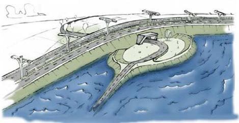
Impression of the A10 North ring road which may be the new boundary of the Randstad dike ring (Koeze & van Drimmelen, 2011).
The report concludes that the greatest gain can be achieved in improvements in the first layer, but that considering additional measures to further mitigate the residual risk is an interesting exercise. The application of the multilayer safety strategy in urban areas, particularly the second layer, is complex and requires a made-to-measure approach, which by its nature can result in cost-effective measures and effective spatial integration. However, knowledge about flood risks is still very limited, which creates lost opportunities for critical infrastructure (Koeze & van Drimmelen, 2011, p. 28).
It is recommended that a national policy be developed for evacuation routes so that in the event of expansion of motorways, railway infrastructure and the like, an assessment can be made as to whether underground or aboveground tunnels would be desirable from the perspective of flood risks and evacuation strategies. Additionally, clear guidelines are required for construction and management of new vulnerable and critical infrastructure to ensure that if a flood event occurs important facilities, such as transport, electricity grid, hospitals, etc., will remain operational for as long as possible and will be quickly restored if a failure occurs. It also appears that safety regions are not well-equipped to withstand major flood events (Koeze & van Drimmelen, 2011, p. 7).
This is a heavy responsibility that should be entrusted to the regional parties, namely the local authorities and the water board. The central government also has a responsibility to develop generic policies and legislation, especially with regard to the protection of critical infrastructure (Koeze & van Drimmelen, 2011, p. 33).
Case Climate Proof Areas Schouwen Duiveland
Based on the Multilayer Safety Strategy at Schouwen-Duiveland - Exploring solutions with a focus on road infrastructure (Hillen et al., 2011)
The aim of the study is to flesh out a vision for a flood-resilient and sustainable road infrastructure on Schouwen-Duiveland. The study takes a long-term view (2050-2100).
The results of the study will serve as input for the Interreg project Climate Proof Areas (CPA), pilot Schouwen-Duiveland as well as for the formulation of a policy and plan for Schouwen-Duiveland (and other areas) which will take place later (Hillen et al., 2011, p. 5
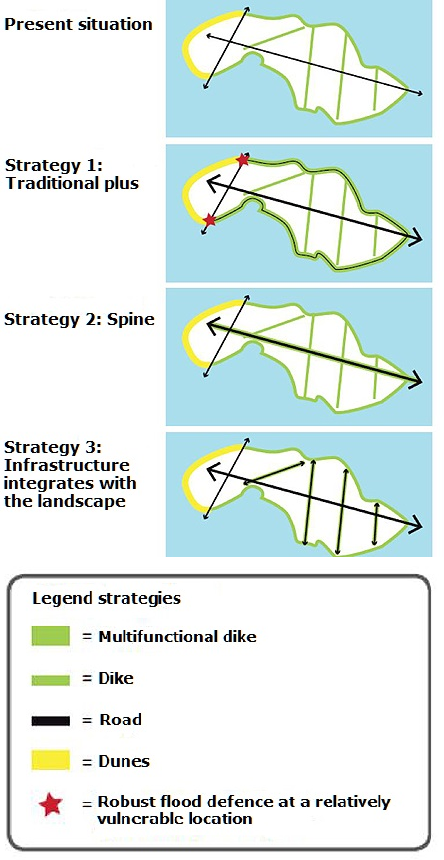
Road infrastructure solutions (Hillen et al., 2011)
This study took an exploratory approach to examine the ways in which flood risks can be managed. The approach began by identifying the characteristics of Schouwen-Duiveland, thinking about strategies and providing examples of how a more flood-resilient road infrastructure could be realised in the long term (Hillen et al., 2011, p. 7).
Three strategies, involving a number of possible solutions, were then developed (see figure). An illustration is presented alongside each solution, showing how the road system facilitates evacuation (off the island or on the island itself) and rescue immediately following a disaster. The descriptions provided here are brief examples of the strategies and are intended to give an idea of how Schouwen-Duiveland can be made more flood-resilient in the long-term. Implementation can take place in phases. Integration with on-going and new spatial developments is therefore possible (Hillen et al., 2011, p. 47).