English resume
Managed realignment
This Deltafact is about managed realignment for coastlines and rivers. Controlled inundation of land through managed realignment is an increasingly applied method for flood and risk management and adaptation to climate change.
|
Thema |
Waterveiligheid, Het kustsysteem |
|
Tags |
|
|
Downloads |
- INTRODUCITON
- RELATED TOPICS AND DELTA FACTS
- STRATEGY: WORKING WITH NATURE
- SCHEMATIC
- TECHNICAL CHARACTERISTICS
- GOVERNANCE
- COSTS AND BENEFITS
- LESSONS LEARNED AND ONGOING STUDY
- KNOWLEDGE GAPS
- EXPERIENCES
Introduction
Intertidal habitats and natural coastlines provide an important buffering function for flood protection. Habitats absorb and attenuate wave energy and in turn provide protection against flooding and prevent erosion, also during storm events. In addition, the intertidal areas move landward to a proportionately higher elevation as sea levels rise. Man-made flood defences form an obstacle for these natural processes to occur. These were constructed decades ago to prevent the flooding of low lying coastal and estuarine areas. While these constructions enabled the land to be developed or used for agriculture, hydro-morphological processes and functions of a water body were constrained. A fixed line of flood defence leads to narrowing of the intertidal area - a phenomenon known as coastal squeeze.

Managed realignment is a concept that deals with the problems caused by man-made flood or coastal defence structures constraining water flow and/or otherwise hindering the hydro-morphological processes and functions of a water body. In many cases, these problems are exacerbated by the effects of climate change (e.g. sea level rise, increased precipitation leading to increased flow, etc.).
Managed realignment is about facilitating the process of re-naturalising low lying areas in a controlled way such that both the flood defence role and the nature conservation value of intertidal areas is optimised. It is about making space for water, but in an economically efficient and ecologically beneficial way.
A number of other terms may be used as an alternative to managed realignment. These include managed retreat, set back, dike realignment, dike (re)opening, de-embankment and de-polderisation.
Managed realignment applications for coastlines and rivers
The principles of managed realignment relate equally to coasts, estuaries and rivers and to many situations where the natural physical evolution of the water body is constrained or prevented by human intervention.
At coastlines, shingle ridges and sand dunes naturally migrate inland. Historically, man has tried to maintain these features as a fixed line, so as to provide flood or erosion protection to the hinterland. However, as sea levels rise and/or sediment supply changes, these features can deteriorate and their natural flood or coastal defence function can be reduced or lost. Managed realignment of shingle ridges or sand dune systems seeks to facilitate the process of realigning (or retreating) to a more sustainable line of flood defence, usually further inland. The same arguments also apply to cliffed coastlines where coast protection structures can prevent the natural release of sediment with the consequence that areas downdrift are starved of their sediment supply - exacerbating problems of flooding or erosion.
For riverine situations, man-made defence structures may disconnect the river from its floodplain, which can result in higher flow rates downstream and sometimes to serious flooding. On the other hand, uncontrolled (unmanaged) realignment of the river may lead to significant human losses. The concept of managed realignment as applied to river systems is therefore about making space for water/room for the river to function in a natural way; about re-connecting the river to its flood plain and thereby relieving unacceptable pressure / flood risks elsewhere. Further, managed realignment on some rivers will form an important adaptive response to the increased precipitation.
Controlled inundation of land through managed realignment is an increasingly applied method for flood and risk management and adaptation to climate change. In the United Kingdom, managed realignment can comprise a cost-effective and sustainable response to loss of biodiversity and sea level rise. Managed realignment is also applied in countries such as the United States, Germany, Belgium and the Netherlands.
Related topics and Delta Facts
Key words: Managed realignment, dredged material, working with nature
Related Delta Facts: Sand Nourishment, beneficial re-use of dredged material
Strategy: working with nature
Managed realignment is based on a strategy of ‘working with nature’. Working-with-nature is an approach in which optimal use is made of natural dynamics such as wind, water, sediment and vegetation and may lead to a positive effect on nature. Working with Nature solutions contribute to multifunctional land use, such as nature development, flood risk management, fresh water supply, fisheries, recreation and infrastructure.
The use of natural dynamics leads to solutions which are more adaptable in anticipating to (uncertain) changing, natural or socio-economic conditions. On the other hand, natural dynamics are inherently less predictable due to variability of weather conditions but also the complexity of ecological and morphological processes. Therefore working with nature solutions require adaptive pathways for decision-making and an adaptive governance approach to facilitate implementation and maintenance of the working-with-nature solutions. Adaptive pathways include the use of multiple scenarios on future socio-economic and physical developments (e.g. climate change or land-use) and possible actions. An adaptive governance approach includes principles of continuous and collective learning to include new insights and knowledge, a participatory monitoring program, wide participation of stakeholders, and a continues process of reflexive decision-making. This is contrary to more conventional approaches where after implementation projects are finished. The dynamic and unpredictable character of working with nature solutions, require a continuous process of decision-making.
Similar concepts to working with nature are ‘building with nature’, ‘eco-engineering’, ‘ecological enhancement’ and other.
Schematic
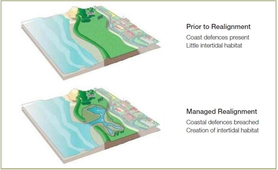
In the pictures below the differences prior and after realignment (figure 1) are shown.
Technical Characteristics
By means of managed realignment, new intertidal areas are created for flood protection and biodiversity. Managed realignment is a prevention strategy. Managed realignment can be applied to anticipate on sea level rise due to presence of salt marshes and tidal flats. The attenuation of wave energy by means of salt marshes provides long-term reduced risk of flooding and coastal erosion.
The benefit of creating intertidal habitats lies in the fact that they are highly effective at attenuating wave energy. This helps to reduce offshore sediment transport and therefore erosion. Intertidal habitats also form dense root mats which increase the stability of intertidal sediments, helping to reduce erosion rates (USACE, 1989). In most cases, the objective of realignment is to create salt marshes. Salt marshes develop between mean high water springs (MHWS) and mean low water springs (MLWS), in areas shaped predominantly by tidal processes and silts and mud.
Besides flood protection other goals and services (eco-system services) are provided that have potential for multifunctional use such as recreation and cultivation of saline crops and fisheries. The area can be used as a water retention area during extreme water levels in narrow river mouths.
In order to apply managed realignment, a number of conditions must be present. Six of the most important conditions are given below (Gardiner et al., 2007; Rupp-Armstrong and Nicholls, forthcoming):
- Presence of coastal defenses
- Availability of low-lying land
- Desire or need to improve flood or coastal defense systems
- Presence of a sustainability-oriented coastal management attitude and a societal willingness to maintain the notion of managed realignment;
- Desire or need to create intertidal habitats
- Societal awareness about the benefits of managed realignment
Governance
It is essential that coastal managers involve stakeholders including local communities in the realignment planning process. Effective stakeholder and local community engagement is essential to successful implementation of managed realignment schemes. Participation of stakeholders can help to:
- Understand legitimate concerns, reservations and interests
- Explain and convince the local community of a scheme’s benefits
- Manage expectations
- Develop stakeholder ownership
In other studies, regulatory/legal and financial difficulties have been identified as a barrier to implementation. It is frequently the case that the process of managed realignment must deal with several coastal land owners who will be affected by the scheme. This has a big socio-economic consequence for the landowners. As a result there can be difficulties concerning the responsibilities and liabilities of certain land owners or authorities.
Costs and benefits
The costs of managed realignment schemes vary widely and depend on numerous factors such as:
- Cost of the land where managed realignment will be performed;
- Requirement for compensation to land owners/occupiers;
- The need to dismantle roads and infrastructure and other human-made structures present on the site to prevent marine pollution caused by the substances which are present in these structures;
- Requirement for and size of new build sea defenses to protect the hinterland;
- Availability and cost of human resources including expertise on supervise and coordinate the process
- Scale and frequency of monitoring
In developed countries where managed realignment has been applied, in most cases the main costs are related to purchasing land. This may be different for developing countries where land prices are not as high. Land costs can vary widely depending on the current land use and ownership. For example, agricultural land is usually less expensive compared to land used for housing or industry. This is mainly due to the presence of infrastructure. If land is used for housing or industry it may also be necessary to provide additional compensation for relocation.
Costs are likely to be lowest if existing defenses are left to breach naturally. This saves money which would have been spent on the creation of artificial breaches. In Germany, the cost of realignment is seen as a major barrier to implementation of managed realignment, since the majority of the North Sea defenses are in excellent condition (Rupp & Nicholls, 2002). The scale of monitoring operations post-realignment will also influence costs. The more rigorous the monitoring schedule, the higher the likely costs.
There is a lot known about the costs of managed realignment. Insight or an overview of the benefits of managed realignment is much more difficult. This is because most of the benefits like increasing intertidal area or more biodiversity are difficult to express in terms of monetary value. Quantifiable benefits are income through tourism and recreation. These benefits are not always directly clear.
Lessons learned and on-going study
Controlled inundation of land by setting back sea defenses is increasingly applied for coastal protection and adaptation to climate change. There are numerous examples of management realignment sites in the United Kingdom. Management realignment is considered as a cost-effective and sustainable response to loss of biodiversity and sea level rise. Besides the UK, management realignment is applied in the Unites States, the Netherlands, Germany and Belgium.
Knowledge gaps
Managed realignment is not a universal solution that can be applied at any location.
The purpose of managed realignment can be re-connecting the estuary to its flood plain, making space for water to function naturally. Controlled inundation of land through managed realignment is also an increasingly applied method for creating intertidal habitats.
In both cases the governance aspects (effective stakeholder and local community engagement) is essential for successful implementation of managed realignment schemes. Knowledge and guide on the approach is needed.
Experiences
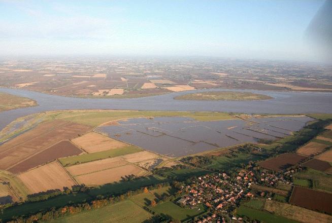
In the Humber Estuary (UK), a new tidal exchange structure combined with the lowering of 1500m of the remaining defence reconnected the estuary to its floodplain. This solution provided strategically important flood storage and facilitated the creation of more than 300 ha of wetland habitat. A shorter embankment in the hinterland was constructed to protect the village and other assets. While it was technically feasible to raise and strengthen the flood embankments, managed realignment provided the extra benefit of additional storage capacity and enabling the creation of compensatory habitat. The additional flood storage capacity improved the ability of the system to deal with extreme water levels, reducing vulnerability and increasing resilience.
The case “Managed Realignment Alkborough Flats” is an example of the development of a more sustainable, cost-effective and resilient (in climate change terms) solution to flood risk management in low-lying areas.
- Figure 2. Aerial view of the Alkborough Flats managed realignment flood storage in operation. Photo courtesy of Environment Agency