 English resume
Room for the river
The Room for the River concept is related to river restoration or rehabilitation, sustainable river management, river flood management and river widening.
|
Thema |
Waterveiligheid, Waterveiligheidsbeleid en regelgeving |
|
Tags |
B&O waterkeringen B&O watersystemen primaire keringen regionale keringen waterbeheersing |
|
Downloads |
- INLEIDING
- RELATED TOPICS AND DELTA FACTS
- STRATEGY: WORKING WITH NATURE
- SCHEMATIC
- TECHNICAL CHARACTERISTICS
- GOVERNANCE
- COSTS AND BENEFITS
- LESSONS LEARNED AN DONGOING STUDY
- KNOWLEDGE GAPS
- EXPERIENCES
Inleiding
Deltas are attractive to live, economically develop and regenerate. The development of river floodplains is especially interesting in areas when available land is scarce. In this Delta Fact we elaborate on a concept dealing with floodplain development: Room for the River. The core of the room for the river concept is giving more space to the river in order to increase the velocity of the flow or to reduce the water level of excess flows and time of exposition to large floods. It can be described as a ‘’simultaneous move from vertical flood defences [reinforcing embankment’s] to horizontal expansion (widening) of rivers, and from vertical, top-down management to more egalitarian forms of multi-actor network governance’’ (Warner et al, 2013). It is a resilient approach accepting that flooding may occur now and again, but seeks to exploit the advantages of flooding and mitigate the disadvantages. It is a broad
concept, applicable and adjustable to many different circumstances (Warner et al, 2013). The Room for the River concept is related to river restoration or rehabilitation, sustainable river management, river flood management and river widening (Warner et al, 2013). Variants of the concept are executed worldwide.
Related topics and delta facts
key words:working with nature, flood risk management
Strategy: workingwith nature
Room for the river is based on a strategy of ‘working with nature’. Working-with-nature is an approach in which optimal use is made of natural dynamics such as wind, water, sediment and vegetation and may lead to a positive effect on nature. Working with Nature solutions contribute to multifunctional land use, such as nature development, flood risk management, fresh water supply, fisheries, recreation and infrastructure.
The use of natural dynamics leads to solutions which are more adaptable in anticipating to (uncertain) changing, natural or socio-economic conditions. On the other hand, natural dynamics are inherently less predictable due to variability of weather conditions but also the complexity of ecological and morphological processes. Therefore working with nature solutions require adaptive pathways for decision-making and an adaptive governance approach to facilitate implementation and maintenance of the working-with-nature solutions. Adaptive pathways include the use of multiple scenarios on future socio-economic and physical developments (e.g. climate change or land-use) and possible actions. An adaptive governance approach includes principles of continuous and collective learning to include new insights and knowledge, a participatory monitoring program, wide participation of stakeholders, and a continues process of reflexive decision-making. This is contrary to more conventional approaches where after implementation projects are finished. The dynamic and unpredictable character of working with nature solutions, require a continuous process of decision-making.
Similar concepts to working with nature are ‘building with nature’, ‘eco-engineering’, ‘ecological enhancement’ and other.
Schematic
The room for the river approach consists of a number of separately applicable measures. Eight measures of the room for the river approach are presented in the figure below.
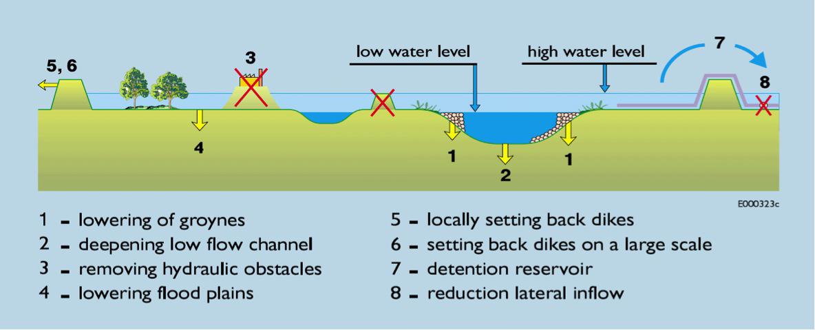
Figure 1. Eight different Room for the River measures (Silva et al., 2001)
The different measures work as follows (Room for the River, 2013a):
- Groynes stabilise the location of the river and ensure its correct depth. However, in a high water situation, groynes may obstruct the flow to the river. Groynes reduce the inundation time duration, increasing floodplain resilience.
- Excavating/deepening the surface of the riverbed creates more room for the river. Eco-engineering solutions can produce natural channel designs.
- If feasible, removing or modifying obstacles in the riverbed will increase the floodplain discharge capacity.
- Lowering/excavating part of the floodplain increases room for the river in high water situations
- Relocating a dike inland widens the floodplain and increases room for the river
- Relocating a dike inland on a large scale will widen the floodplain on a larger scale and will create more room for the river.
- The dike on the riverside of a polder is lowered and relocated inland. This creates space for excess flows in extreme high water situations.
- Reducing the lateral inflow by measures in the field of land use. Retention will reduce peak water flows by storing the water upstream. Runoff production can be reduced by for example reforestation.
Two more possible measures, which are not part of figure 1, are:
- Creating a by-pass or a high water channel. This is a dyke area branching off from the main river to discharge some of the water via a separate route.
- A proper land use planning within the floodplain, preventing the increase of flood exposition in the future.
Similar solutions can be depicted for coastal wetland areas, where inundation is produced by accumulation of flood waters due to the low drainage capacity of the associated dune systems.
Technical characteristics
Relocation of rivers is a natural phenomenon. New river branches appear and old ones are cut off. For example, in the Netherlands around 40 displacements occurred in the last 5000 years. The first embankments in Europe were built in Roman times to protect urban areas, military and other installations. During medieval times embankments became a less rare phenomenon. Between 1000–1400AD the first river branches were embanked in the Netherlands (Kleinhans et al, 2013).
The embankments frequently resulted in higher flow velocities and therefore a reduction of sedimentation in the basin areas. The normalisation of rivers prevented that gullies changed location and advanced the discharge of water, ice and sediments. Since, lateral erosion became impossible and the hinterland supplied a limited amount of sand, the river gully deepened. In the last century, dredging further reduced the available sediment. This resulted in a more divided landscape that was beneficiary for shipping and still prevented the land from flooding. These developments have possible negative consequences rivers. Further deepening may lead to solid layers become barriers for shipping, increasing potential flood consequences, possible drying out of floodplains and instable river junctions (Kleinhans et al, 2013). Besides that, the steadily improved protection of the land allowed more intensive usage increasing damage potential increased.
Between 1973 and 2002 the annual number of reported flood disasters in Europe increased. However, throughout the 20th century, flood-related causalities were either stable or decreasing while economic losses of flooding became worse (Climate Adaptation, 2013). The higher number of floodings and increase of economic losses created possibilities to execute different approaches to prevent floodings.
In general, the room for the river approach (as an alternative for dike reinforcement) can be categorized in different categories of measures (Silva et al, 2001): reduction of the flow of (extra) water; storage of (extra) water along the rivers; discharge of (extra) water via the rivers.
Reduction (measure 8): This includes measures in the field of land-use and retention. Adjustments of the usage of land will influence the water balance (the flow of water in and out of a system) in the catchment area by allowing more precipitation to evaporate and infiltrate. While land use measures can be beneficial during less extreme discharges, in the case of extreme circumstances, these have less effect on river discharge. During long periods of heavy rainfall evaporation and absorption capacity of the ground are almost zero, resulting in a direct runoff. Implementation of land-use changes can be complex and a long-lasting trajectory.
Storage (measure 7): Diverting and (temporarily) storing river water in retention areas along rivers leads to a reduction (smoothing) of the peak discharge wave. In a retention basin, the peak of the flood wave is captured. The quantity of water that is present in this ‘peak’ is left behind in an area big enough to store it. Retention areas have to be surrounded by sufficiently high dikes, via an overflow or another type of construction. Implementing retention areas requires space has to be available. Retention areas do not require permanent occupation of land as retention area. It can be incidental use of the area (only in the case of extreme discharges). Such incidental use may require financial compensation for damage occurring during usage of the area as a retention basin (Silva et al, 2001).
Discharge: This option refers to measures that increase the discharge capacity in the riverbed. It comprises: measures in the low-flow channel (measures 1 & 2); measures in the flood plain (measures 3 & 4); and measures in flood-protected areas (measures 5 & 6) (Klijn et al, 2012).
Measures in the low-flow channel are lowering the riverbed and the groins. Lowering of the riverbed has immediate effects on the water level upstream and at the site of intervention. However, the river will erode in upstream direction and cause a rapid sedimentation in the dredged area. Lowering the groins causes the lowering of all water levels.
In the floodplains, obstacles can be removed and the floodplain can be lowered. Removing obstacles, such as bridge abutments, factories on mounds, involves the removal of man-made elevations which disturb the free flow of the river. Lowering the floodplains properly can be regarded as imitating a natural erosion process (Klijn et al, 2012).
Measures in the flood-protected areas (‘behind the dike’) include relocating embankments and creating bypasses. Both measures literally imply ‘giving back’ floodplain area to the river and restoring the natural floodplain ecosystem. With relocations, the existing embankment is removed and a new flood defence is constructed further inland. Setting back dikes is particularly effective at places where the flood plain is very narrow. Bypasses function as new ‘floodplains between two embankments’ (Klijn et al, 2012).
In urban areas the flood plain / space is often very limited, this causes high water levels during peak discharges. In these cases, the river discharge can be increased using natural channelization designs. But bottlenecks within urban regions often not be solved by river widening or deepening measures. Measures that may solve these bottlenecks are large-scale setting back of dikes and the creation of green rivers. Green rivers can be seen as (artificial) flood plains between two dikes. During low river discharges the river does not fill these floodplains, but during floods the extra quantity of water is discharged by the floodplain. During low discharges, the floodplain may be used for agricultural, natural or recreational purposes (Silva et al, 2001).
Example: The Netherlands
One of the most tangible examples of the room for the river concept is the room for the river program in the Netherlands. In 1993 and 1995, the Dutch river region and its residents were confronted with extremely high water levels. Although the dikes just managed to resist the water, large areas were affected and 250.000 inhabitants were evacuated. The floods triggered a rapid reinforcement of the existing embankments as well as a policy change in dealing with river floods (Klijn et al, 2012), resulting in the Room for the River program. The project started in 2006 with a designing process and is planned for completion by 2015 (Rijke, 2012).
The objectives of the Room for the River program were to accommodate a discharge volume of 16.000m3/s in the branches of the Rhine by 2015 and at the same time improve the spatial quality in the river region.
To cope with the objectives 39 measures were selected to lower the flood level of the River Rhine and its branches in the Netherlands (figure 2). The ‘Planning Kit’ was used to select the 39 measures. This tool consists of a collection of (hydraulic) model results and an estimate of costs and compared various measures. It was used to take well informed decisions. The 39 measures should enhance spatial quality (Klijn et al, 2012). In order to meet this goal an interdisciplinary Quality Team (Q-team Room for the River) was installed. This Q-team was commissioned to coach planners and designers, to peer review the designs and plans on spatial quality (Klijn et al, 2013). The final implementation of the measures was decentralized to local or regional authorities (like water boards), sometimes partly to private parties.
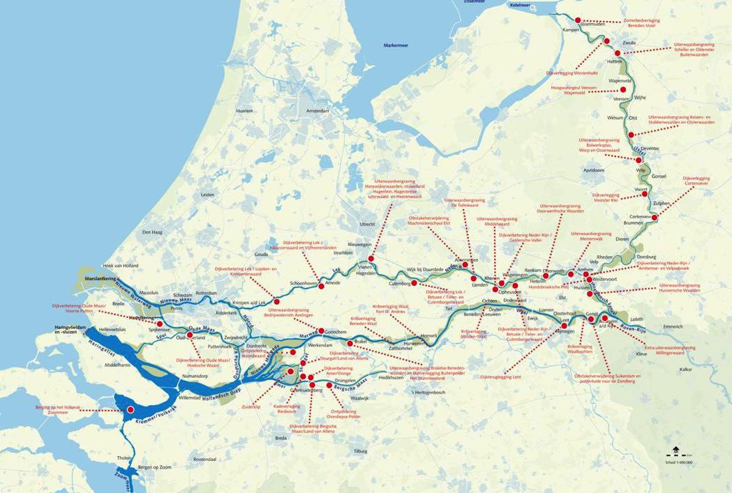
Figure 2. The 39 measures implemented (www.ruimtevoorderivier.nl)
Almost all of the measures implemented were ‘discharge’ measures, such as lowering of the floodplains, dike relocation and deepening of the river channel. On locations where room for the river type of measures were not feasible regular dike heightening and dike improvement were proposed.
Retention measures were not selected due to the high protection levels in the Netherlands and public resistance. Retention is mainly effective for floods with a probability of 1:10 to 1:100 years. Since in the Netherlands flood protection along the river is based on protection levels higher than this probability, retention cannot reduce these flood protection levels. In addition, the effectiveness of retention is relative uncertain (timing and need for large water storage areas) (Klijn et al, 2012).
Governance
The room for the river concept implies to shift from ‘’vertical, top-down management to more egalitarian forms of multi-actor network governance’’ (Warner et al, 2013). It involves a broader range of stakeholders, but also more bottom-up searches towards more inclusive measures of river management. Making room for the river is not common practise; it is both a technical and a policy innovation. Hence, in applying the concept actors have to find out how to implement this new policy paradigm. Consequently new legislation, new forms for inter-organisational collaboration, new appearances of public-public and public-private coordination and new forms of governance often accompanies the room for the river approach (Van Buuren et al, 2013; Verkerk & van Buuren, 2013).
Since the approach includes multi-actor network governance, collaboration and involvement of many different parties is expected. Although this holds in most cases, realizing measures is only possible when the actions of various governance levels and domains are connected. How actors interact with each other differs per country. For example, in countries as France and UK flood risk management is both a public and a private responsibility. Consequently, there are many interactions between insurance companies and governmental agencies. Although the level of interaction differs, collaboration is a general characteristic in the room for the river approach (Van Buuren et al, 2013). Not in every part of the world room for the river measures imply involvement of a broader range of stakeholders and bottom-up approaches. For example in China and Indonesia room for the river measures resulted in the forced movement of thousands of people. The approach described here does not include this kind of practises (Warner et al, 2013).
Countries including the United States, Australia, United Kingdom, Denmark, Germany and countries in South East Asia conducted projects similar to the room for the river concept in the Netherlands. The origin of room for the river concept can be manifold: the projects are ecological, flood safety or climate change driven. Another driver for realizing more room for the river is the worldwide attention for integrated river basin management (Verkerk & Van Buuren, 2013).
An important trigger of implementing the room for the river approach is the occurrence of (near) disasters. However, general trends in society such as the democratization of society and emancipation of citizens and stakeholders groups and the trend towards sustainability and quality of life have also affect the decision to implement the room for the river approach (Verkerk & Van Buuren, 2013).
The following elements can help to build up more governance capacity for implementation of the room for the river concept (Van Buuren et al, 2013):
- Building regional coalitions: important that a broad array of stakeholders is involved in making proposals. Developing relational capacities to bridge the multilevel gap.
- Realizing and maintaining connections between organizations.
- Designing governance processes that combine decision-making and deliberation: Although the governmental processes are different in different countries it is important to realize consensus and to mobilize necessary resources.
Example: Governance in the Dutch room for the river program
The application of the room for the river concept in the Dutch room for the river program was a multi-actor collaboration. In the program ‘‘the government is aiming for an integrated approach to flood protection in the river Rhine area, with a coherent strategy that takes account of the area’s functions and the interests at stake there”. The National government described the measures in general terms. On a regional level actors had the possibility to propose additional measures, alternatives or new initiatives. Consequently, the national government, regional governments, the public and the business community were involved in planning and implementation of the projects. The room for the river program is considered as one of the first adopted approaches in which NGO’s and private stakeholders in different disciplines at national, regional and local levels are actively collaborating to reduce the flood risk and to enhance the spatial quality (Zevenbergen et al, 2013).
Costs and benefits
Constraining the river has its price (notably flood risk and loss of natural carrying capacity) but so does making space. More space for the river easily means less space or less opportunity for other functions that are also societal appreciated (e.g. housings, business areas and other) (Warner et al, 2013). The costs of
room for the river measures differ per country, but are relatively easy to calculate. On the contrary, the benefits of room for the river are more difficult to value. Flood safety, nature and recreation may positively benefit from room for the river measurements, while agriculture and shipping may negatively benefit. Effects on recreation and nature are difficult to estimate and even more difficult to monetize.
Costs
In the Netherlands a cost effectiveness analysis and a cost benefit analysis on the optimal safety strategy were performed. Cost effectiveness of the reduction of the water level was expressed as mm/million euro or m2/m euro. This allows for selection of the most cost effective measure for each river branch or river stretch. The general conclusion was that relocating embankments, bypasses, lowering groins and lowering floodplains yielded the largest design water level effect per million euros invested. The most expensive measures were the removal of hydraulic obstacles and lowering floodplains (Silva et al, 2001). It was also concluded that spending more than 2 billion euro for improvement of flood protection in the Dutch rivers was economically viable (CPB, 2005; Eijgenraam, 2005).
Benefits
The effects of room for the river measures are manifold, affecting agriculture, nature, housing, cultural heritage and shipping. The benefits of these effects depend on the type of measure. For example, there are different possibilities to lower floodplains: by means of nature development, replacement of dry and humid nature for wet nature or with vegetation management. All these variants will yield different benefits (Klijn et al, 2012). Besides that, the benefits of the measures highly depend on the location.
Lessons learned and ongoing research
Evaluation of the Dutch Room for the River program
The room for the river program is considered as a successful project. In the Netherlands, it is the first major infrastructure project to be realised on time and within budget (Rijke et al, 2013). The flood protection objective will be reached for 61 per cent in 2015. This will grow during the years after (Andersson Ellfers Felix, 2013).
The contextual factors that made the program a success are (Zevenbergen et al, 2012):
- Availability of space: Making room for the rivers requires available space to conduct one of the measures. Dense urban communities or critical infrastructure may impede this. This will call for adopting a system basin approach.
- Flood history: Although a new paradigm of making room for the river has set before the nearly floodings of 1993 and 1995. This acquires the political will to approve the governmental decision for the room for the river program.
- Legitimacy for integrated river basin management: In the 1980s the local stakeholders and the public were in general enthusiastic about the basic principles of room for the river.
- Multi-level and cross-sector collaboration: The ‘Polder Model’ of compromise and deliberation encourages a coordinated system-wide approach. Engagement of different governmental levels is assumed to be vital institutional conditions for the Room for the River program.
European Centre for River Restoration
Since 1995 the European Centre for River Restoration, based on a framework of national networks,enhances and promotes river restoration and sustainable river management throughout Europe and disseminates information on river restoration experiences and approaches and to foster the establishment of national river restoration networks in as many European countries as possible. Best practices, lessons learned and literature references can be found at: www.ecrr.org. Also www.restorerivers.eu supplies information on best practices of river restoration.
Knowledge gaps
The Dutch room for the river program is almost completed. Although most knowledge gaps have been solved during the program, there are still some remaining questions: the effect of making room for rivers on flood risk (probability x consequence) has never been properly quantified (Klijn et al, 2012), the same counts for a cost benefit analysis including benefits for nature, culture historic value and more.
Other knowledge gaps are the opportunities to link spatial planning, policy or tasks to the room for the river program and the ability to adapt to potential larger river flows in the future (Rijke et al, 2013). Furthermore, the effect of the approach on water supply is a knowledge gap. International there are many knowledge gaps such as the transferability of the concept to (developing) countries. Although, the factors that made the program a success have been identified, the context will be different in another country and approaches have to be adapted.
Experiences
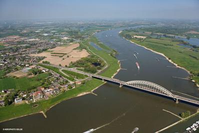
Island in the river Waal
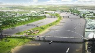
A bottleneck within the room for the river program was the part of the river Waal flowing through the city of Nijmegen. Enclosed by an urban area, the river had limited space to discharge all the incoming water. In Nijmegen two large room for the river measures were proposed, the construction of a bypass and setting back of the ‘Lentse Waaldike’. Since, the area is highly urbanized, finding public support for these measures is very important. The agreement has been reached in participation with many stakeholders such as local residents, NGO’s and the local government. The process included an extensive Environmental Impact Assessment and planning study followed by a design and technical plan. Currently, there is enough public support for the measures resulting in a faster implementation process.
The plan comprises a relocation of the dike 350 meter inland. This creates space to build a bypass, which will give more discharge capacity during high water levels. This means a large spatial intervention for the city of Nijmegen, around 50 houses have to make room for the water and there will be build a large city park in between the historical centre and the city district Waalsprong.
The plan needed to fulfil a water level reduction of 27 centimetres and an enhancement of the spatial quality of Nijmegen. Both of the goals are reached, even a water level reduction of 35 centimetres has been achieved (Ruimte voor de Waal, 2013).
Environmental restoration and educational use of Almenara Marsh
Almenara Marsh is located besides the coast, originally occupying fields of several municipalities in the province of Castellón (Spain). The marsh area was reduced significantly in the past, mainly by agricultural land development. Nowadays only one water body at Almenara municipality is remaining.
The environmental restoration of this marsh was proposed by the Júcar Basin Water Authority to solve flood problems in a residential coastal urban area. The area is located between the marsh and the sea. Works finished in 2013 with a total cost of 900,000 €.

The main objectives for this project were: (1) use the wetland as a sacrifice area during flood periods, releasing water to the sea after the storms; (2) wetland restoration and landscape improvement; (3) control the water level and the connection with the sea in order to improve the biodiversity and environmental aspects of the wetland; and (4) educational/social use of the restored wetland.
For flood protection a drainage canal was constructed parallel to the coastline between the wetland and the residential area. The historical agricultural drainage system has been maintained. To increase the water control capacity a pumping station has been constructed.
This project is a clear “Working with Nature” project since it uses natural processes to restore a degraded wetland and use it in periods of flooding as a sacrifice area. In addition, the project has produced environmental and social gains: the wetland water balance is controlled and the ecosystem functions have been improved. The marsh is turned into an improved natural habitat for many species, including endangered ones.