 English resume
Brackish seepage
Brackish to saline groundwater is common to many areas of the Dutch coastal lowlands. The purpose of this Delta Fact is to describe the different aspects of, and measures against, saline seepage.
|
Thema |
Zoetwatervoorziening, Delta facts, English versions |
|
Tags |
|
|
Downloads |
- INTRODUCTION
- RELATED TOPICS AND DELTA FACTS
- HOLD, STORE AND SUPPLY STRATEGIES
- TECHNICAL SPECIFICATIONS
- DEFINITIONS OF FRESH/BRACKISH/SALINE GROUNDWATER
- MEASURES
- GOVERNANCE
- COSTS AND BENEFITS
- FIELD EXPERIENCE AND CURRENTLY ACTIVE RESEARCH
- KNOWLEDGE GAPS
- EXPERIENCES
Introduction
Brackish to saline groundwater is common to many areas of the Dutch coastal lowlands. To explain this phenomenon, we need to look at the last thousands of years. During that period, when the sea level was lower than it is today, fresh water flowed from the highlands into the sea. But the gradual rise of sea levels and the resulting subsidence of land surface have dramatically altered that landscape. The figures in the schematic below show how this process has occured over the past 1000 years and how it has led to the distribution of fresh and salt water in the Netherlands (see Fig. 1). During the many Holocene transgressions, North Sea salt water emptied into large (lowland) areas of Zeeland, Holland, Flevoland and Friesland, invading the groundwater system holding infiltrated rainwater and thus highly fresh and often calcareous groundwater, and driving the much lighter fresh water deep underground. The mixing and changing groundwater flow patterns have transformed the once clear transition zones between fresh and salt water into brackish groundwater zones in some areas. Since the construction of deep polders (reclaimed land), the low polder levels enable the upward seepage of brackish to saline groundwater to the surface towards the ditches. This movement of saline groundwater from the upper aquifer to the surface is called saline seepage. There are three types of seepage with differing seepage fluxes and salinities (see Fig. 2): 1. diffuse seepage of saline groundwater through the semipermeable layer; 2. preferential saline seepage through sandy paleochannel belts in the confining layer, and 3. intense seepage via localised boils in waterways or on the land (small area, preferential groundwater flow) (De Louw et al., 2010). The highest concentration of groundwater is found at boils through which groundwater preferentially discharges at high velocities, thereby resulting in upconing of deeper and more saline groundwater. Hence, the higher salinity of boils than diffuse sand seepage. In many deep polders, the salinity of the surface water system is therefore largely determined by these saline boils (De Louw, 2013). Where rainwater or fresh surface water supplies are limited, saline seepage leads to salinisation of the surface water, shallow groundwater and sometimes even the root zone; a process known as internal salinisation (Alterra, 2011 fact sheet).
It should be noted that groundwater extractions in the Netherlands not only account for water system salinisation, but also for freshening the water system and the local upconing of saline groundwater: however, because freshening and upconing are not the focus of this Delta Fact, they will not be further addressed here. The purpose of this Delta Fact is to describe the different aspects of, and measures against, saline seepage.
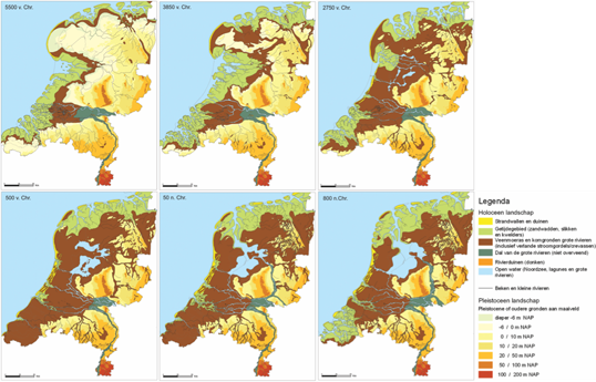
Figuur 1. Redevelopment of the landscape since the last ice age (Bazelmans et al., 2011).
References: Bazelmans, J., Weerts, H.J.T. en van der Meulen, M.J., 2011 Atlas van Nederland in het Holoceen - Landschap en bewoning vanaf de laatste ijstijd tot nu, Uitgever: Bert Bakker, ISBN: 978 90 351 3639 7.
[Bazelmans, J., Weerts, H.J.T. and van der Meulen, M.J., 2011, Atlas of the Netherlands in the Holocene epoch – Landscape and human habitation since the last ice age, Publisher: Bert Bakker, ISBN: 978 90 351 3639 7]
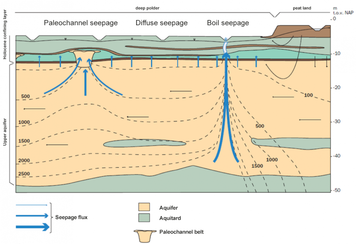
Figure 2. Three different types of saline seepage that differ in flux and salinity (De Louw, 2013).

Figure 3. Depth of the brackish-saline groundwater interface, CI concentration = 1000 mg/l. (left) and seepage (blue) and infiltration flux (red) (right, NHI 3.0 model result).
Related topics and Delta Facts
Keywords: groundwater, saline seepage, salt-fresh water, salinisation, Netherlands Hydrological modelling Instrument, fresh water supply, boils
Delta Facts: Rainwater lenses, Salt-tolerant crops, Controlled drainage
Hold, store and supply strategies
Agriculture and nature benefit from the availability of fresh to slightly brackish water. Saline seepage leads to salinisation of the surface water, shallow groundwater and, in some cases, even the soil water in the root zone, thereby limiting fresh water availability. In areas affected by saline seepage, increased salinity can render the surface water unfit for irrigation and cause drought damage to crops, while increased root zone salinity can affect crop growth and damage the crops and/or natural vegetation.
The measures to counteract the adverse effects of saline seepage are in line with the strategies hold and store:
- Hold fresh (meteoric) water during periods of water surplus (in winter and during rainstorm events) using smart drainage (controlled drainage) systems and other solutions;
- Actively store fresh water in aquifers during periods of water surplus for use in dry periods. Some trials in Southwest Delta show that storage of fresh water in aquifers can lead to larger fresh groundwater reserves which, during dry periods, can be extracted for irrigation when and where needed; see www.go-fresh.info;
- Temporarily dam drainage level areas affected by extensive saline seepage in dry periods so as to keep the rest of the polder water fresh. The temporarily stored salt is discharged during rainstorm events when it is highly diluted.
For the status of “improve resilience” and “work with” processes, see e.g. the Meta Study on Fresh Water Supply and Demand in Southwest Delta (de Vries et al., 2009). The study evaluates the climate resilience of current land use and water supply for a number of subareas based on high-end climate change projections, and explores the options for long-term policy strategies:
- continue to improve resilience to salinisation through system adjustment;
- work with salinisation and treat salinisation issues separately from agricultural water use, and
- hybrid solutions.
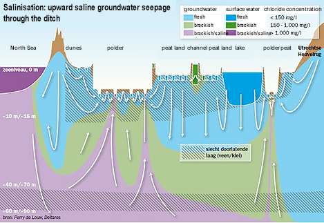
Figure 4. Simplified east-west regional profile with groundwater flow patterns and groundwater salinities at the Haarlemmermeer polder. Groundwater system salinisation occurs on regional scale as the average polder level is several metres below the mean sea level. Saline groundwater in the polders (reclaimed land) is upconed by the boils in the polder. The saline boils are the dominant surface water salinisation mechanism.
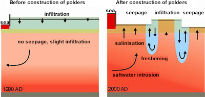
The water system at locations where fresh water infiltration used to take place in the distant past has changed dramatically since about 1000 AD. Elevated embankments along the main rivers and construction of locks in waterways have resulted in a pattern of small, enclosed areas surrounded by dikes, the so-called polders. More efficient drainage has also led to subsidence of the land surface, enabling local freshening at the transition zones of highland areas, where infiltration occurs, and lowland polders with saline seepage (see e.g. Bader, 2005).
Technical specifications
The seepage flux can be calculated using the following formula (Darcy’s law):
qz = Δφ /c
where
qz = the vertical velocity through a resilient layer = seepage [m/day]
Δ φ = head difference between head in aquifer and phreatic water level (e.g. polder level) [m]
c = hydraulic resistance of the semipermeable layer [d].
Hydraulic resistance is determined as follows: c = d/kv, where d is the thickness of the semipermeable layer [m] and kv the vertical hydraulic conductivity [m/d].
The determining factors for each location are:
- aquifer head
- polder level
- semi-confining layer thickness
- hydraulic resistance of semipermeable layer
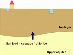
The conventional method of calculating salt loads involves multiplying the seepage flux by the chloride concentration at the base of the confining layer. However, recent research (De Louw, 2013) shows that boils are the dominant salinisation mechanism in the salt loads to many deep polders and that this calculation method results in underestimation of the salt loads. In the new version of the Netherlands Hydrological modelling Instrument, the boils are explicitly factored into the calculation. The conventional method of salt load calculations, however, applies to shallow polders with barely any boils, such as the Southwest Delta and the Northern coastal area.
Definitions of fresh/brackish/saline groundwater
Fresh, brackish and saline groundwater are variously classified, depending on the intended use and other possible factors. The term fresh groundwater, for example, has a different meaning for a bulb grower than for a beet farmer. Stuyfzand’s classification of drinking water supply (1993) is the common standard used in the Netherlands. The classification used in the western part of the Netherlands is based on the vulnerability of crops to damage (200, 600 and 1000 Cl mg/l), which is the approach used in water management (Cultuurtechnisch Vademecum). In the Zeeland Delta, where the groundwater is naturally brackish to saline, the chloride concentrations rarely fall below 150 mg Cl/l. Hence, the introduction in Zeeland of the term agronomic fresh, which defines 1000 mg Cl/l as the boundary between fresh and brackish groundwater. This boundary is widely used in other countries as well (Davis & De Weist, 1980; Todd, 1980). Table 1 lists the definitions for fresh, brackish and saline groundwater.
| Class | Chloride concentration (mg Cl-/l) |
| Fresh | < 1000 |
| Brackish | 1000 - 3000 |
| Saline | > 3000 |
Table 1. An increasingly used definition for fresh, brackish and saline groundwater. The concentration of chloride, a conservative substance which incurs no losses due to chemical reactions or biochemical degradation compared to other substances, is the dominant salinisation mechanism (Oude Essink, 2001).
Measures
Measures against saline seepage are implemented to deliver fresh surface water to the functions that depend on it. Risks of surface water salinisation by saline seepage are mainly present in the Dutch lowlands.

Figure 5. Areas with possible saline seepage (initial fresh/brackish/saline groundwater distribution at the base of the confining layer. Source: ZZRegis data and NHI fresh-saline groundwater)
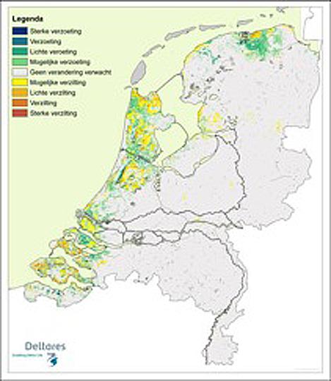
Figure 6. NHI fresh-saline groundwater model calculation: areas with increasing and decreasing salt concentration at the base of the confining layer over the next 100 years. The yellow to red areas are areas that will be affected by seepage with increasingly higher salt concentrations (salinisation) in the future. The salinised seepage water is called autonomous salinisation; seepage fluxes in the coastal area will increase only slightly due to sea level rise, but will otherwise remain constant. The salt loads, however, will increase as deeper and more saline groundwater flows to the surface.
The traditional measure used to prevent saline seepage of brackish to saline surface water is flushing. Voorde and Velstra (2009, p. 10) write the following about this: ‘At its core, flushing is an effective measure to ensure that the surface water quality standard (MTR value of 200 mg Cl/l) is met. The availability of high-quality fresh water, however, is constrained by autonomous developments, such as:
- higher salt concentrations due to saline seepage, necessitating more flushing;
- decreasing quantities of readily available good quality water due to decreasing river discharge and thus less available water in the IJsselmeer, and also due to the intrusion of seawater in rivers.
And increasing demand for good quality water due to:
- higher user requirements for producing high-quality, capital-intensive crops (whereby more, higher quality water is required)
| User measures | Status | Management measures | Status | Policy measures |
| 1) Create local fresh water supplies | This measure consists of four solutions: small rainwater lenses floating on saline groundwater, creek ridges, ASR and desalinisation. See Delta Fact rainwater lenses | 3) Seal saline boils | Seepage reduction technologies (model reserach) Field research on boil sealing completed | 7) Standardisation |
| 2) Adapt agricultural land use | Existing crops are acclimated to local growing conditions (and development of salt-tolerant crops in areas affected by saline seepage is pursued, see Delta Fact Salt-tolerant crops | 4) Ísolate’ the water system | This measure applies to areas with high-salinity surface waters. | 8) Regulate land use |
| 5) Counteract saline groundwater seepage (water level increase) | Water level increase in the Noordplas Polder | 9) Brackish water supplies to enable saltwater crop cultivation | ||
| 6) Manage brackish water streams | This measure is implemented in conjunction with spatial planning | 10) Water supply | ||
| 11) Pricing |
There is currently little or no research detailing the efficiency of many measures. This presents a knowledge gap that needs to be addressed. Below is a list of the measures applicable to saline seepage:
- Sealing saline boils
This can be achieved in two ways: through injection of expanding and persisting fluids or biosealing. If expanding and persisting gels are used, it is advised to use an environmentally friendly gel. Biosealing is by definition environmentally friendly. Field research (De Louw et al., 2012) (De Louw et al., 2007) shows that sealing naturally occurring boils (which arise from the heaving and cracking of the confining layer) is very difficult and cannot be achieved with current technolgies. This is because a relatively large area (about 20 by 20 metres on average) is affected by the heaving and cracking of the confining layer, rendering the area unstable and riddled with cracks. Boil sealing fairly quickly leads to development of new boils in existing cracks in the unstable boil area. Boil sealing has proved to be much simpler and more promising for boils which arise from the removal of structures, such as level filters or sheet piles, or from the sealing of old gas wells. - Adjusting the polder water system
Adjusting the intake, discharge, storage and drainage systems is a promising measure for saline polders. This requires identifying the saline drainage level areas and building a bypass around it to isolate the saline area and prevent it from being used in summer. This system can be further optimised through dynamic operational management of drainage, fresh water intake, and temporary storage of saline seepage water based on weather forecasts and real-time monitoring of salt concentrations at strategic locations in the polder. Automatic weirs can easily control the temporary isolation of drainage level areas with a significant number of boils during dry periods. The temporarily stored salt water can then be discharged during rainstorm events when salt concentrations are low. - Counteracting saline seepage
One solution is to increase the water levels in the surface water system. Increasing surface water levels could be effective when applied in ditches with many large boils (> 0.5 m) or with significant diffuse saline seepage. While this solution has been applied in some areas, it has proved difficult for the water manager to garner support for adjusting the system. Research into this was conducted at the Noordplas Polder, see Experiences.
Governance
When farms use ditch water for irrigation, or when saline seepage reaches the root zone, it can affect the fresh water supplies: high salt content can cause salt damage to crops, especially in dry summers in coastal areas; see Experiences for how the Rijnland water board addresses this problem. Usually, the lack of fresh water presents an even greater problem. During dry periods, saline seepage often renders the surface water unfit for irrigation due to high salt content, leading to drought damage in areas without water supply.
Areas affected by saline seepage present governance challenges concerning questions such as: how can salt seepage be prevented and how can redevelopment, crop adaptation and the like, be used to anticipate and thus benefit from rather than prevent saline seepage? Saline seepage affects land use in the area. A trend that has come into focus in this regard is the increased self-sufficiency, see the experience on Texel (saltwater crops and the fresh water storage trials in Southwest Delta, including active participation in the Knowledge for Climate programme, Tranch 2, Climate-Proof Fresh Water Supply). For more information, please visit Valorisation of promising solutions to robust fresh water, GO-FRESH). Local authorities and interest organisations recognise the urgency of this issue: this should lead to raising awareness of the issue among farmers and to more involvement in solving the expected fresh water problems through implementation of new innovative solutions such as controlled infiltration and drainage systems, in conjunction with participatory stakeholder processes, such as is applied in De Waterhouderij.
Costs and benefits
In recent years, an accessible tool has been developed which provides fast and interactive access to information about the current fresh water supply for a region or (part of a) catchment, and offers different approaches to distributing fresh water in times of water scarcity: the €ureyeopener. The €ureyeopener has already been used to cost out the measures for two sub-areas: the Rijnland water board (Stuyt et al., 2012) and the Southwest Delta and Rijnmond-Drechtsteden regions (Schipper et al., 2014).
Seven water management measures have been costed out for Rijnland. An example: increasing the allowable chloride content of the supply water in all Rijnland areas by 300 mg/l from the baseline situation (10% in dry years) lowers Gouda’s intake requirement to 65 million m3 (4.1 m3/s) (baseline situation is 114 million m3) and increases agricultural damage to € 32.5 million (+30%).
The future fresh water supplies in the Southwest Delta and the Rijnmond-Drechtsteden regions (SWD-RD) have been secured in various ways. Each measure considered for this purpose affects the polder water chloride content and thus the quality of the irrigation water for agriculture and the environment. Users can (interactively) introduce the intended measures during meetings with stakeholders; the model then immediately calculates the effects (water requirements, salinities of regional waters, physical yield changes in agriculture) as well as the direct costs of the measures. Given the calculated costs and benefits, the following costed-out measures are therefore projected to be favourable: 1. water conservation through infiltration in creek ridges (with water supply); 2. water conservation through level increase without water supply (pilot in Flanders); and 3. reduction of the intake water salt content.
Field experience and currently active research
Doctoral research in saline seepage (De Louw, 2013)
December 2013 marked the completion of a six-year doctoral research in salt seepage. This research revealed the dominant role of saline boils in surface water salinisation in many deep polders, including the Noordplas Polder and the Haarlemmermeer Polder, where the research was conducted. In addition, the prevalence and dynamics of shallow rainwater lenses that develop below agricultural fields in areas with saline seepage were also studied in the Southwest Delta. Saline seepage prevents intrusion of rainwater, resulting in very shallow rainwater lenses (<2.0m). However, most locations suffered from lack of fresh groundwater, and saline seepage water had already penetrated the unsaturated zone.
Timeline: 2007-2013
Freshening-salinisation of phreatic groundwater in the province of Zeeland
In this project, research was conducted into groundwater salinisation in the upper meters of the subsoil due to sea level rise and a changing climate. The main objective was to analyse the various water management measures for effectiveness in controlling salinisation in agricultural and natural environments in Zeeland. Special attention was given to the so-called relatively shallow rainwater lenses in agricultural fields, as well as to the seasonal field/ditch interaction arising from upwelling saline groundwater. In addition to developing a reliable 3D modelling tool for density-dependent groundwater flow and interconnected network of salt transport, a comprehensive multi-year monitoring pogramme will be implemented to expand the predictive capability of the modelling tool.
Timeline: 2006-2011
Climate-Proof Fresh Water Supply (Knowledge for Climate Theme 2, Fresh Water Supply)
This programme aims to contribute to finding robust, flexible and long-term solutions to the Netherlands’ fresh water resources at different spatial scales in a changing Delta. The focus of the research is on local and regional solutions to agriculture, horticulture and the natural environment in the Dutch lowlands. The fresh water resources in these areas face two threats: drought, in general, and ground and surface water salinisation, in particular. The programme includes six interrelated work packages where the areas will be analysed for how they can become more self-sufficient and how changes in the (main) water system can contribute to their water supplies. The six work packages consist of: WP1: Climate change in the Netherlands from a European perspective - our constraints; WP2: Adaptation of fresh water resources and buffer capacity of the interconnected groundwater/surface water system; WP3: Adjusting functions to fresh water reduction; WP4: Water storage and technology as a tool for regional self-sufficiency; WP5: Possible solution strategies from the perspective of uncertainty, and WP6: Case studies Green Backbone, Haaglanden and the Southwest Delta.
Several doctoral research projects within this programme are briefly listed here:
- Doctoral research by Joost Delsman: Development of a quantitative framework to optimise adaptation strategies for drought, and ground and surface water salinisation due to climate change.
- Doctoral research by Pieter Pauw: Enhancing the robustness and flexibility of fresh water lenses in areas affected by saline seepage as a result of climate change.
- Doctoral research by Koen Zuurbier: Aquifer storage and recovery for independent regional water supply.
Timeline: 2010-2014
Determining future salinisation of groundwater resources in South Holland
For the Province of South Holland, a study was conducted into the changes within fresh groundwater bodies affected by autonomous developments, different sea levels, subsidence and climate change. A 3D numerical density-dependent groundwater model (cells 250 * 250m2: ~ 9500 km2) was developed to quantify the effects of human intervention, such as the effect of brine discharges into the second aquifer and coastal land reclamation, in terms of increased salinisation and salt load to the surface water system.
Timeline: from 2004-2010
Project Climate change and salinisation in northern Netherlands
in this project, the provinces of Groningen and Friesland and the water boards work together to find answers to such questions as: to what extent does salinisation currently pose a problem for agriculture in northern Netherlands, but more importantly, to what extent can practical solutions be found to meet agricultural needs in the future?
Timeline: 2009-2011
GO-FRESH (Valorisation of promising solutions for SWD (Knowledge for Climate Theme 3)
GO-FRESH (Geohydrological Opportunities Fresh Water supply, or ‘Valorisation of promising solutions to robust fresh water resources in the Dutch lowlands’) is a Knowledge for Climate project in Southwest Delta. A consortium of companies led by Deltares, and including Alterra, KWR, Acacia and Hogeschool Zeeland, will study the extent to which local measures can increase fresh water availability for agriculture in areas not dependent on the main water system. In this project, the underground is used for storage of fresh water in periods of water surplus for use in dry periods. This project focuses on two types of areas likely to be quickly affected by climate change: a. areas with creek ridges with a somewhat deeper lens, and b. areas with saline seepage and shallow rainwater lenses. Three showcases have already been launched within GO-FRESH:
- The Freshmaker: increasing fresh water reserves in a creek ridge by injecting fresh water and extracting saline groundwater;
- Creek Ridge Infiltration Trial: increasing fresh water reserves in a creek ridge by infiltrating surface water;
- Drains2Buffer: optimising the fresh water volume in shallow rainwater lenses by different types of deep drains.
The project also assesses scalability of the solutions: hydrological and economic feasibility. Stakeholders will be closely involved in the project to assess the innovation directly in the field and against real-world scenarios. With this research, we are looking to provide innovative solutions to current and future fresh water shortages and to contribute to the economic development of rural areas and address future local and regional policy concerns. www.go-fresh.info
Timeline: 2012-2014, and relaunch to 2017
Alternative forms of sustainable land use and water management by and for farmers
(2010 – 2013)
Pilot project involving research into whether and how a number of measures will lead to optimisation of soil fertility and moisture condition, sustainable use of agricultural water resources, increase crop production, improve profitability and reduce nutrient loading in water bodies. The measures include level variations in the ditch, fully controlled drainage (infiltration by means of drainage system and holding of water) and continuous underground drip irrigation. The project is carried out by Acacia Water and Deltares, Alterra, Vrije University, LTO, HHNK and the province of NH.
Timeline: 2010-2013
Seepage reduction technologies
The Rijnland Water Board will identify various water supply policy options (particularly salinisation control and eutrophication issues). The options range from a review of the current intake/flushing policy to accepting salinisation and active source control. Different technologies, the effects and efficiency of which are still unknown, are available for this purpose. The Background study Seepage Reduction Technologies identifies a number of technologies for seepage reduction, with special attention to boil reduction, which prompted the field research on boil sealing (De Louw et al., 2012). As described earlier in this fact sheet, sealing naturally occurring boils (arising from heaving and cracking) did not prove to be a promising method.
Timeline: 2007-2012
The €ureyeopener
The €ureyeopener is an accessible tool that provides fast and interactive access to information about the current fresh water supply for a region or (part of a) catchment and offers different approaches for distributing fresh water in times of water scaricity. Following development of €ureyeopener version 1.0 for the management area of the Rijnland water board, the tool was further developed for Southwest Delta and the Rijnmond Drechtsteden regons in support of policy development for the sub-programme Delta Fresh Water Programme. Water managers hope to gain a better understanding of the effects of the current fresh water supply on the benefits in agriculture and identify appropriate and cost-effective measures to make the fresh water supply future-proof. The tool provides useful and clear answers to knowledge questions about the regional fresh water supply. The added value of €ureyeopener 2.0 is its ability to provide fast and interactive access to information about the effectiveness of potentially attractive options for the fresh water intake system by calculating the water and salt balance, translating the effects on agriculture into yield changes and making the effects of the measures immediately transparent by creating an accurate breakdown of costs and benefits. Additional location-specific figures have been collected for calculating the costs of a number of measures.
Timeline: as of 2012
Salinisation of groundwater system in Wetterskip Friesland
Modelling tools help shed light on a number of ways in which level change can affect flooding events, drainage capacity, and especially salinisation, such as ditch and groundwater salinisation and saline seepage, in the coastal area of the Wetterskip Fryslân. The models are also used to analyse different design variations.
Timeline: 2006-2012
Living with salt, Top sector Water
The objective of this business case is to develop a system for quickly and effectively preparing and implementing a comprehensive plan for a region or delta to achieve economically profitable innovations that address the increasing scarcity of fresh water in coastal and deltaic areas. The case is based on four pillars; agro-technological innovations (salt-tolerant crops, aquatic cultivation, etc.), innovations in water management (including climate-adaptive drainage), hydro-technological innovations to desalinate saltwater, and area-specific integration of these innovations.
Timeline: 2012-2020
Drinking water from saline seepage, PURO
Use of salt water as a source for drinking water is considered as a possible additional measure. However, this applies only in very specific situations. In his doctoral research, Frank Smits selected a number of polders in the management area of Waternet where salt water is likely to be found. The idea is to extract saline groundwater from below a deep polder in order to prevent the saline seepage from reaching the locks in the polder. To do so, the underground must be accurately defined, the extraction carefully costed out and the effects on the surface water thoroughly studied. An innovative approach to extracting saline groundwater is the PURO concept, which is currently being field-tested by Oasen, TU Delft, Waternet, Grondboorbedrijf Haitjema and Logisticon Water Treatment, with funding from the InnoWator scheme.
Timeline: 2012-2015
Knowledge gaps
Important knowledge gaps on saline seepage include:
- There is currently no overview that provides insight into the effectiveness of the different measures, or important aspects, such as how they can be scaled up, the areas in which they can be effective and how often they can be used. To what extent is hydrological and economic scale-up of self-sufficient fresh water pilot studies possible? To what extent can saline seepage preventive measures implemented in a few local pilot studies be scaled up to measures that have regional impact? Heterogeneity in terms of fresh/saline groundwater distribution, intensity of saline seepage and geological variability in the subsurface constrain the extent to which measures can be scaled up.
- Impact of uncertainties on hydrological, geological, meteorological and agro-physical processes on the extent of saline seepage.
- To what extent are hydrological modelling tools, such as the NHI and Delta model, capable of providing a reliable representation of local processes that lead to saline seepage? How can numerical processes in local water systems be scaled up and applied to hydrological modelling tools??
- What impact does groundwater system salinisation have on the underground infrastructure (i.e. increase in corrosion of steel pipes)?
- To what extent can saline seepage and pervasive salinisation be accepted?
- To what extent can the environment sustain larger variations in salt concentrations of/in the surface water?
- Which custom measures are efficient in inhibiting or minimising the impact of saline seepage/pervasive salinisation in each area?
- What implications does saline seepage have for the soil structure/quality (geochemical processes, impact on hydraulic geochemical/soil properties)?
Experiences
Interview with Ms B. van der Watereren and Mr J. Rooden of Rhineland Water Board on April 25, 2012
Salt water is not an unknown phenomenon in Rijnland. Saline seepage occurs mainly in deep polders, such as the Haarlemmer Polder and the Noordplas Polder. An intake and discharge system has always been used to flush out the seepage water with fresh river water so as to improve the water quality. Via the pumping station in Gouda, Rijnland diverts fresh water (guideline 250 mg/l) from the Hollandse IJssel into the management area, where the excess water is then pumped out at three locations. Rijnland requires up to 20m3 water/second, of which 3m3 is used for flushing. Flushing is a practical and cost-effective measure (approximately € 200,000 per year) because fresh water is generally available. However, it is often in short supply during extremely dry periods due to salinisation at the intake point, resulting in fewer flushing events. Salinisation poses a significant threat to vulnerable crops (bulbs, ornamental plants) as they fall under categories 3 and 4 of the priority list and are the first to be affected by drought. Special natural environments, such as the Nieuwkoop and Reeuwijk Lakes (in category 1 of the priority list) also require fresh water.
Rijnland recently conducted studies on local salinisation control, using measures such as boil sealing. Between 2008 and 2011, an experiment was carried out in the Noordplas Polder and the Haarlemmermeer Polder, where there is an old creek ridge with a confining layer, a profile without a confining layer and a profile with holes in the confining layer. This led to a very noteworthy observation, i.e. sealing off boils at one location can cause seepage to increase in other locations. Current sealing technologies are inadequate. An important identified knowledge gap is therefore the heaving and cracking mechanism, and mapping this out. More knowledge needs to be gained about the underground to understand how pressure changes can cause heaving and cracking to occur in the surface, so that appropriate measures can be developed to address this problem.
Another measure is level increase. This, too, was studied in the Noordplas research (TNO, 2004), where some drainage level areas were examined for increasing the level up to 30 cm. This measure is included in the level decision that seeks to reduce the diffuse seepage. To achieve level increase, the water system must be redesigned to include barriers, dams and discharge direction change, and the plots must be drained to allow for proper drainage. The first results are expected to be published around 2016. This measure has currently been met with resistance from local stakeholders who fear that it will result in more flooding events during wet periods.
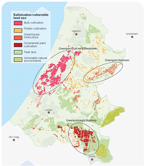
The figure below shows salinisation-vulnerable land use (Rijnland 2009).
References
- The effect of water management on the chloride and nutrient surface water loads in the Noordplas Polder
- Synthesis Report: Definitive water and solute balances and effect of different water management scenarios. TNO, 2004
- Louw, P.G.B., de, van der Velde, Y., and van der Zee, S.E.A.T.M.: Quantifying water and salt fluxes in a lowland polder catchment dominated by boil seepage: a probabilistic end-member mixing approach, Hydrol. Earth Syst. Sci. Discuss., 8, 151-188, 2011.