 English resume
Rainwater lenses
This delta fact addresses the recent insights into the characteristics and occurrence of rainwater lenses in areas with saline groundwater . It provides an overview of possible future threats and management options.
|
Thema |
Zoetwatervoorziening, Delta facts, English versions |
|
Tags |
|
|
Downloads |
- INTRODUCTION
- RELATED TOPICS AND DELTA FACTS
- STRATEGY: HOLD, STORE, SUPPLY
- PERFORMANCE
- TYPOLOGY AND MANAGEMENT MEASURES
- COSTS AND BENIFITS
- GOVERNANCE
- FIELD EXPERIENCE AND CURRENTLY ACTIVE RESEARCH
- KNOWLEDGE GAPS
Introduction
A large part of the Netherlands is situated below the current sea level. Since the last ice age, this lower land has regularly been inundated by the sea, which has allowed seawater to infiltrate the underlying parcels of sand. Since the land has been reclaimed (polders), there has been seepage and this saline groundwater is rising to the surface and salinizes the surface water, shallow groundwater and sometimes even the root zone. In some places, the surface water and groundwater are unsuitable for crop irrigation. Crops also experience salt damage when the saline water seepage reaches the root zone by means of capillary action.
Luckily, the Netherlands has a precipitation surplus, which creates fresh rainwater lenses on the brackish to saline groundwater. In the current situation, rainwater lenses in saline areas are of extreme importance to agriculture. The thickness, form and dynamics of these meteoric lenses differ from area to area. Different factors play a role in this, such as the geo-hydrological composition, drainage, water level management, the seepage and infiltration flux and groundwater replenishment.
Owing to climate change resulting in drier summers and a rise in sea level, the water system could be under such pressure that the supply of fresh groundwater on plot level and the regional fresh water supply could be in danger. Research has shown that a relatively small increase in saline seepage and a small decrease in precipitation surplus in the summer can significantly decrease the fresh water stock on plot level (De Louw, 2013). In addition, the existing thicker freshwater lenses that have formed - under sand bodies that are positioned at a higher level – such as dunes and creek ridges (in infiltration areas) are enlarged due to active infiltration and this increases the availability of fresh water.
This delta fact addresses the recent insights into the characteristics and occurrence of rainwater lenses in areas with saline groundwater. It provides an overview of possible future threats and management options.
In areas that are not under the influence of the sea such as higher laying areas in the Netherlands, rainwater lenses are also found and are due to the separation between groundwater and rainwater. These lenses are of local importance in the nutrient poor peat areas for instance. These kinds of lenses are outside the scope of this delta fact.
Related topics and Delta Facts
Key words: fresh water supply, salinization, salt damage, fresh water lens, saline seepage
Delta facts: controlled drainage, soil as a buffer, salt tolerant crops, brackish seepage
Strategy: hold, store, supply
Rainwater lenses are a way to improve and protect a strategy of holding on to fresh water in soil that has saline ground water.
Different low laying parts of the Netherlands were exposed to inundation with seawater during the Holocene sea level rises and the accompanying phases of transgression and regression (shifting coastlines). Because of this saline inundation, the sandy Pleistocene sub-surface contains brackish to saline groundwater. The depth of the brackish-saline groundwater varies substantially from less than 5 meters in large parts of the south-western delta and the northern coastal area to 20-25 meters deep in west Netherlands (see figure below).
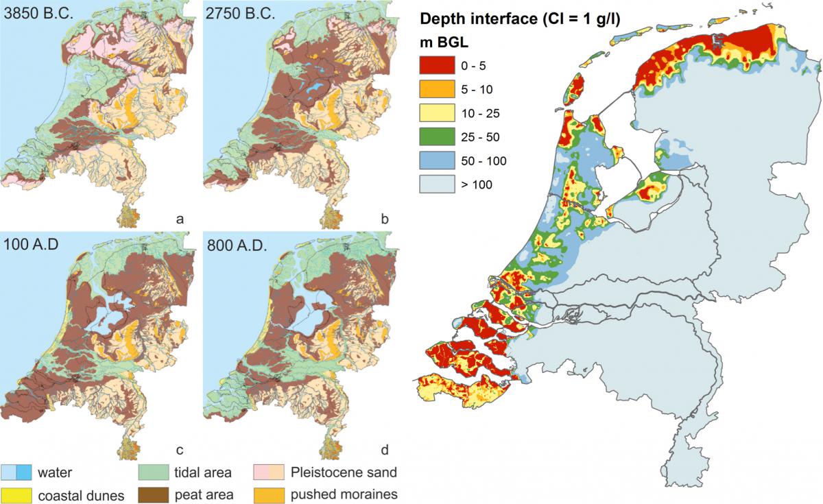
Palaeogeographical maps of the Netherlands during the Holocene epoch, showing the presence of saline groundwater in the sub-soil. The maximal expansion of the sea (3850 AC) shows the area where saline groundwater is found within a depth of 100m. In areas that were more recently inundated by the sea on the geological time-scale (800 AD) the saline water is found at a shallow depth (<5 m) such as in Zeeland and Friesland-Groningen.
There is an important distinction between rainwater lenses in saline seepage areas and fresh water lenses in infiltration areas. Fresh water lenses are found in infiltration areas of 5 to 100m thick while the rainwater lenses in seepage areas are often no thicker than 3m because the upward flow pressure prevents the infiltration of rainwater. In seepage areas, they are called rainwater or meteoric lenses as opposed to fresh water lenses because the groundwater in these lenses is often brackish or saline due to mixing with the saline seepage water. These thin rainwater lenses are of great importance to agriculture as they regulate the salinity in the root zone. Rainwater lenses in saline seepage areas are very vulnerable to the effects of climate change. The risk of saline water reaching the root zone of agricultural crops increases. Management measures can contribute to the mitigation of this effect. The thicker rainwater lenses under the dunes and creek ridges are of substantial importance as a source of fresh water supply that can be used for irrigation.
Performance
Seawater has a higher density (ρs is approximately 1025 kg/m3) than fresh (rain) water (ρf is approximately 1000 kg/m3). A direct result of this is that under statistical conditions, fresh water ‘floats’ on saline water, analogous to the floating of ice (with a lower density) in water. In this situation, the buoyancy of fresh water in combination with the dome-shaped bulging of groundwater levels result in the formation of fresh water lenses. The most simple form of this is found in the coastal dunes, where thick rainwater lenses form in a relatively homogenous (sand)parcel. The appearance of these lenses is a classic example of a scientific prediction in hydrology. In 1888, Badon Ghijben (BG) formulated the theoretical explanation to show how, based on the density difference between rainwater and saline (sea) water, a bulging in groundwater level h above ditch level, the bottom of a rainwater lens at a depth of H = ρf / (ρs - ρf) x h is beneath ditch level. At a seawater density ρs = 1025 kg/m3 it applies that H = 40*h. The figure below is an illustration of this equation.
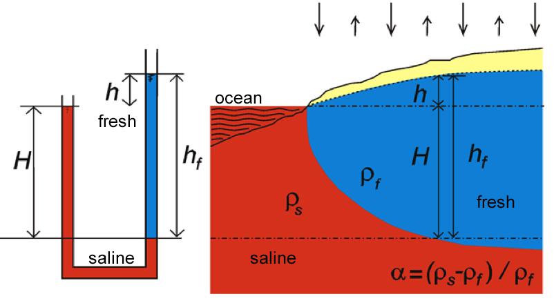
An illustration of the theoretical approach used by Badon Ghijben with regard to the bottom of a fresh water lens in saline groundwater. (Source: Oude Essink)
In practice however, it appeared that there were more factors to consider than only the hydrostatic balance. The most important of these are:
- Under the influence of (saline) seepage, the transition zone moves up so the Badon Ghijben principle does not apply in seepage areas.
- The boundary surface between fresh and saline groundwater is not as clear as depicted – there is a transition zone, generally a few meters thick – that occurs due to mixing processes.
- Clay layers in the subsoil impede the infiltration of rainwater and will always result in a thinner lens.
- Temporary variations in groundwater level (h) due to substantial fluctuations in groundwater replenishment in time and drainage.
- Drainage skims a significant part of the potential groundwater replenishment.
Even though this is a theoretical approach that can deviate from the actual situation, this BG relation can be used to make an initial estimate of the thickness of a fresh water lens. The fresh water lenses that develop according to the BG principle are called BG lenses and are found in saline Netherlands in the infiltration areas, mostly under higher positioned sand bodies such as dunes, sea walls and creek ridges.
In areas with saline seepage, where the first saline groundwater seeps to the surface through the aquifer, thin rainwater lenses are often found. The upward flow impedes rainwater infiltration (see figure below). Therefore, these lenses develop in the almost impermeable upper layer (clay, peat) and are often no thicker than the upper layer. The rainwater lenses that are found in saline seepage areas are called RW lenses, in order to distinguish between the rainwater lenses in infiltration areas, which are called BG lenses. In the south-western delta (Zeeland, Z-Hollandse islands) en the north (Friesland-Groningen) the saline groundwater is only found to very shallow depths (< 5 m-mv; see map above) and the Holocene upper layer is poorly developed. In saline seepage areas this results in very thin rainwater lenses.
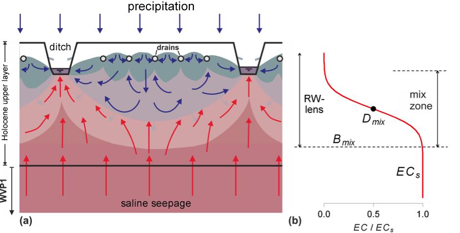
(a) Schematic overview of a rainwater lens in a saline seepage area (RW-lens). (b) Profile of the salinity of the deeper groundwater. Dmix is the middle of the mix zone where the salinity (EC) is half of the salinity of the seepage water (ECs) is. Bmix is the base of the mix zone where the salinity is equal to that of the saline seepage water (ECs). Source: De Louw, 2013)
A recently completed thesis by De Louw (2013) contains extensive research into the characteristics of the RW lenses (see figure above) such as thickness of the RW lens, the saline progression with depth, thickness of the mix zone and the factors that co-determine these qualities. In addition, the temporary dynamic of the lenses is researched and a link is made to the salinities in the root zone. The research showed that hardly any fresh groundwater is found in the RW lenses. At most locations where the saline profile with depth was measured, the upper groundwater had often become brackish already. The mix zone is encountered 1m below surface level and highly salinized groundwater is often found at a depth of 1.5 to 4 meter depth, comparable to 50-80% seawater (see measurements below). The mix zone and the dynamics of the zone determine the degree of salinity and are therefore of great importance to agriculture.
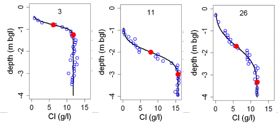
Measurements (blue circles) of the salinity and depth of RW lenses in Zeeland. The red circles indicate the middle of the mix zone (Dmix) and the base of the mix zone (Bmix) (Source: De Louw et al., 2011).
There are different polders (reclaimed land) in Zeeland where sandy Pleistocene subsoil is covered by a thin (~ 5 m) relatively impermeable Holocone upper layer, consisting mainly of silt, clay and peat. Due to a combination of early reclaiming, subsidence and peat degradation, these polders are situated relatively deeply. This, together with being situated close to the coast results in a rather saline seepage flux of 0-0.5 mm/day in Walcheren and Zuid-Beveland, and more than 0.5 mm/day in Schouwen-Duiveland. The dimensions of the rainwater lens in seepage areas are therefore not determined by the Badon-Herzberg principle, but are primarily determined by the size of the seepage flux, the precipitation surplus and the depth of the means of drainage. Under seepage conditions, the rainwater lens is always limited to the upper layer because of the permanent upward flow from the underlying aquifer.
Field trials in Zeeland (De Louw, 2013) and Friesland-Groningen (Velstra et al., 2011) show that the drains have a considerable effect on the transport routes of dissolved salt. Under ‘wet’ conditions with the groundwater table above the drains, upconing of saline seepage to the drains takes place, which then discharges a mixture of seepage and meteoric water. Under ‘dry’ conditions, with groundwater levels below drain level, capillary rise of the saline seepage occurs in the direction of the root zone.
Typology and management measures
Rainwater lenses are found wherever there is saline groundwater. Roughly, we can distinguish three different types depending on the conditions in which they are formed:
- BG lens — Infiltration areas. Upland, permeable soils such as coastal dunes and creek ridges. Relatively thick fresh water lenses of the Badon Ghijben–Herzberg (BGH) type are found here.
- RW lens - Rijnlands type — Seepage areas. Deep polders (reclaimed land) with a thick upper layer, usually with poor permeability in the bottom part of the upper layer (Basic peat under Westland sediments). Under these conditions, saline seepage on the lower layers is bent towards the surface water system, generally via sand bars or wells. (De Louw et al., 2010) and develops a relatively thick lens in the upper layer.
- RW lens - Zeeuws type — Seepage areas. Lowland polders with a thin upper layer and shallow, highly salinated groundwater. Under these conditions, a rainwater lens develops that is never thicker than the upper layer itself and the saline groundwater is able to penetrate into the root zone.
Of these three main types of rainwater lenses, the Zeeuwse type in particular is most vulnerable to climate change. Because of the shallow position of these RW lenses, the thickness depends on the precipitation and evaporation surplus. In a changing climate where the winter is wetter and the summer drier (less precipitation, more evaporation) the RW lens will shrink. Because of increasing evaporation in summer in combination with less precipitation the lens will become thinner in summer while a possible larger precipitation surplus in winter cannot compensate for this. This winter water is discharged (too) efficiently and does not benefit the rainwater lenses. Salinity of the RW lenses therefore increases, which increases the possibility of the root zone becoming more saline (due to capillary rise of the saline RW lens water) and increases the probability of saline damage to crops. Furthermore, the saline seepage flux will increase due to rises in sea level, which will put even more pressure on RW lenses. This only applies to a small zone along the coast (1-5 km) where the rise in sea level has a significant effect on the groundwater system. The Rhineland type lens is thick enough to keep functioning under the current climate scenarios. The BG lens could nevertheless be negatively affected by climate change. This will depend on the changes in annual precipitation surplus. The thickness of BG lenses is less dependent on changes in precipitation surplus throughout the year, in contrast to the RW lenses where the distinction between summer and winter groundwater replenishment is of substantial importance. If the annual average in precipitation surplus decreases due to climate change, the BG lens will shrink and if the annual precipitation surplus increases, the BG lens can even grow.
- Adjusting the drainage system. By positioning the drain water pipes deeper in the soil if the drainage base remains constant, they are able to discharge more saline seepage water and less fresh rainwater, which will result in thicker rainwater lenses. This reduces the probability of excessive salinity in the root zone. This measure is called drains2buffer and is currently being tested in the field at Schouwen-Duivenland, in the Go-Fresh project. One alternative is installing Controlled Drainage, with which the drainage of rainwater can be maximized in winter and the supplement to the rainwater lens can be maximized.
- Infiltration in Creek ridges. By actively infiltrating water into the higher positioned creek ridges, existing BG lenses can be enlarged so that the fresh water supplies can be used for irrigation purposes. However, due to the upward pressure of the surrounding saline groundwater, the groundwater levels will have to be permanently raised to keep the lens from drifting upward (see BG principle above). This measure is currently being field tested in Walcheren, in the Go-Fresh project (Pauw et al., 2014). An alternative is the combination of fresh water infiltration by extracting saline groundwater to keep the growing lens in position. This principle is called the Freshmaker and it is also being tested in the Go-Fresh project. (Zuurbier, 2014).
- Fresh water from elsewhere. Many, but certainly not all, areas with thin rainwater lenses are positioned near the coastal dunes as this is were BG lenses are often formed. Part of the fresh water surplus that flows from here, now often unused, mixes with the regional surface water whereas it can be tapped and used as irrigation water. Separation of sweet and saline ditches is very important in this.
Level management. The surface water level functions as a base for drainage and therefore, it co-determines the division of precipitation surplus between lateral drainage and vertical infiltration. Higher levels, during winter for instance, result in more infiltration and therefore in thicker rainwater lenses.
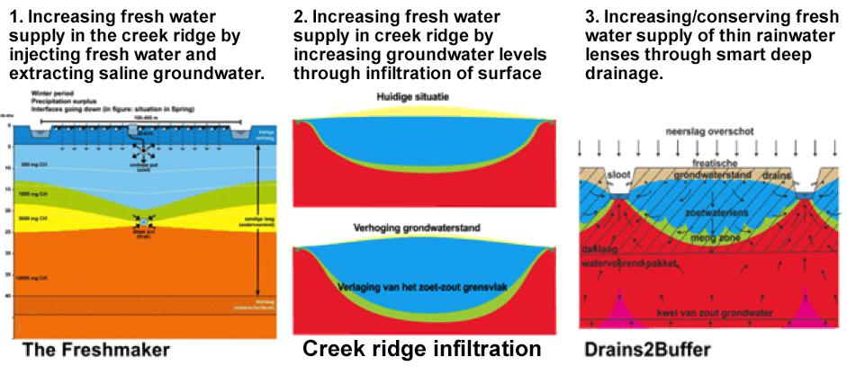
The three Go-Fresh measures that are being field-tested for effectiveness in the KvK-project Go-Fresh.
In the framework of the KvK project Freshwater Options Optimizer national suitability maps were made (on the base of national data) that indicate which areas are suitable for the application of the three Go-Fresh measures (van Bakel et al., 2014).
Costs and benefits
It is not easy to estimate what the costs and benefits of the abovementioned measures will be before hand. Firstly, the costs are not clear as some of these measures are in an experimental phase. Secondly, the benefits are not clear due to market effects. In ‘dry’ years, where there is relatively high saline stress due to drought, which results in lower yields, the bad harvest could cause the price to be high and the total financial yield will actually be higher than during a ‘normal’ year.
Governance
The fragility of rainwater lenses of the Zeeuwse type requires considered, locally focused water management. In practice, the farmers involved manage the water in this way. Of the stated management options, the optimization of BG lenses under creek ridges in particular is dependent on good regional (management) synchronization given that water management on one location (creek ridges) is put in service of another at another location (saline seepage areas). The water board has a prominent role in this. A ‘waterhouderij” concept, which is a sort of partnership between several users and suppliers of fresh water, could be of service here.
Field experience and currently active research
All farmers in the Zeeuwse and Noord-Nederlandse polders in saline seepage areas have practical experience with rainwater lenses. Research experience was mainly gained in Zeeland (de Louw et al., 2011-2013, Pauw et al., 2014, Zuurbier et al, 2013), Rijnland (de Louw et al., 2010) and Noord-Nederland (Velstra et al., 2011). In Zeeland, field trails were started with controlled drainage at a deeper level to increase RW lenses (drains2buffer) as well as trails for optimizing the enlargement of fresh water supplies under creek ridges (creek ridge infiltration, freshmaker) in the KvK-project Go-Fresh in 2012.
Kustlaboratorium (www.kustlaboratorium.nl) is a field laboratory in Zeeland (Schouwen Duiveland), where integral field-testing is done around (briny) aquaculture, coastal safety and nature and landscape development. Within this project much attention is focused on the effects of adaptation in the area set up regarding dehydration, hydration and salinization of the area and the directly surrounding area.
www.cliwat.eu - 'Climate and Water'. An EU InterReg project in which Deltares executed rainwater lens research. Zeeland is a CLIWAT pilot area.
www.climateproofareas.com - 'Climate Proof Areas'. An EU InterReg project containing various climate adaptation projects in Schouwen-Duiveland, among which is making rainwater lenses more robust.
aequator.nl/waterhouderij - Project focus is the enlargement of self-sufficiency by buffering precipitation surpluses in the winter for use in summer.
Knowledge gaps
The primary controls on the forming and thickness of rainwater lenses is fairly well understood thanks to various measurement and modelling studies. The remaining knowledge gaps are mainly in:
- Process details
- From field observation (Velstra et al., 2011, de Louw et al., 2011, 2013) it has become clear that the flow processes in the unsaturated zone, such as capillary rise and around the drains is more complex than previously thought. These processes are relevant to the salinity in the root zone and thus, to possible salt damage and the saline load to the surface water. There is a need for better understanding of these processes, especially in a quantitative sense, and in particular of the interaction between the RW lens and the salinity in the root zone.
- Effectiveness measures
- The intended measures to enlarge the BG lenses and the RW lenses are largely based on insights obtained from small-scale field experiments and modelling studies. The field experiments have not been completed yet. Up-scaling these local measures is a challenge. There are also some scaling problems regarding the translation of saline water flux from large-scale groundwater models to seepage flux on plot level.