 English resume
Dynamic level management
Dynamic water level management involves anticipating conditions based on previously determined preconditions concerning water level margins as stipulated in the Water Level Decision.
|
Thema |
Zoetwatervoorziening, Delta facts, English versions |
|
Tags |
|
|
Downloads |
- INTRODUCTION
- RELATED TOPICS AND DELTA FACTS
- STRATEGY MULTI-LAYERED SAFETY
- SCHEMATIC
- TECHNICAL SPECIFICATION
- GOVERNANCE
- COSTS AND BENEFITS
- PROJECTS AND CURRENTLY ACTIVE RESEARCH
- KNOWLEDGE GAPS
- EXPERIENCE
Introduction
Status: this topic is still under discussion
Dynamic water level management involves anticipating conditions based on previously determined preconditions concerning water level margins as stipulated in the Water Level Decision. This is a pro-active form of water level management that continuously takes the current and expected groundwater situation into account. Instead of a fixed level or a normal summer and winter level, the level varies within the parameters set in the water level decision. Dynamic water level management better enables adaptation to changing weather conditions, levels of soil moisture and variations in groundwater levels. In doing so, water management can be more finely attuned to agricultural business operations. It can be applied for sufficient water availability during drought (to prevent drought damage in agriculture and land subsidence due to peat degradation) or for opposite reasons such as discharging more water to prevent flooding and for optimizing agricultural business operations. Dynamic water level management is still in a research environment.
‘In the broadest sense of the words, level management is the supply and discharge of water while adjusting the water level to the use and destination of water and the soil while meeting the related quality requirements. In the strictest sense of the words, level management is to manage the level in the storage basins and watercourses of a polder by means of intake and discharge, whereby a fixed water level is being pursued. There is a substantial difference between the different forms of level management and their scope of application.’ (Hemel, 2007, p.7). In practice, the following forms of water level management can be distinguished:
| Form | Beneficiary / function | Level |
| Regular level management | Agriculture, urban development | A fixed higher level in summer and a fixed lower level in winter. |
| Fixed level management | Urban development, nature | A constant level throughout the year |
| Flexible/natural level management | Nature, water management (less intake and discharge of water) | Free within an upper and lower boundary, which means decreased intake and discharge in the polders (more self-sustainability). (passive/following/extensive) |
| Dynamic level management | Agriculture | Continual adjustment based on weather conditions, crop growth conditions and agricultural business operations. It is a game within the space permitted by the Water Level Decision and is based on groundwater levels. In polders it results in increased average intake and discharge. (active/ anticipative/ intensive) |
Related topics and Delta Facts
Key words: Groundwater controlled level management, operational groundwater management, underwater drainage
Delta facts: Pricing of water for agriculture, soil moisture-based irrigation and effectiveness of water intake
Strategy multi-layered safety
The strategy of fresh water supply can be subdivided into:
1 hold, 2 store, 3 supply
| Measure | Region | Soil type | Land use | |||||
| High Netherlands | Low Netherlands | Sand | Clay | Peat | Agriculture | Urban | Nature | |
| Dynamic level management | + | + | + | ± | ± | + | - | - |
The possibilities of dynamic level management depend on the specific conditions in an area and therefore differ per area. It is applicable in level controlled areas. It should be noted that in high-Netherlands there is more room within the target level decision to apply this measure than the room available in low-Netherlands and valley stream areas.
Dynamic level management is a measure that can have a positive effect on all types of soil. The speed with which the groundwater level responds to level management differs however: on soil that drains poorly (peat and clay) the reaction generally is slower than it is on sandy soil. In sandy soil there is less delay in the action. On the other hand, peat and clay areas generally have more ditches that can be used to execute dynamic level control, which decreases the distance between level change and groundwater table change and with that, the response time.
Dynamic level control is used to better address the varying demands made on the groundwater situation by the different functions (e.g. agriculture versus subsidence) at different times during the year. By taking current and future weather conditions into account, flooding or drought can be prevented, for instance by creating extra storage to accommodate the storage of peak precipitation. Dynamic level control sets higher requirements for the capacity of the water management system and is less suitable for nature targets as the application results in a higher dynamic in water supply and discharge and therefore, in a loss of local water and larger requirement for the supply of non-local water.
Schematic
Components of the water system that are important with regard to dynamic level management consist of:
- groundwater level
- weir and pumping station levels (water intake and discharge)
- drainage
- weather conditions (meteo)
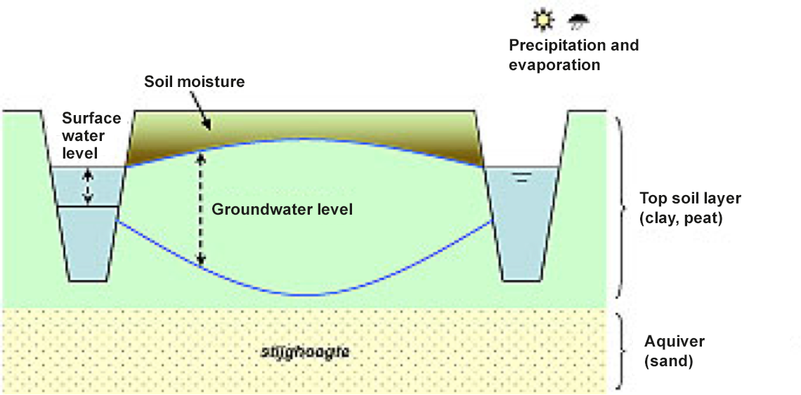
Conducting dynamic level control is a policy measure and involves a decision to not control summer and winter water levels (seasonal level), but to use current and/or expected conditions. A protocol states when level changes come into effect. A monitoring network is used to keep abreast of the present groundwater situations, quantify effects (afterwards) and make decisions about changes in water levels. Operational deployment of a model supports in determining the current and future situation and prior estimates of the effects of water level changes.
A schematic of the operational water system:
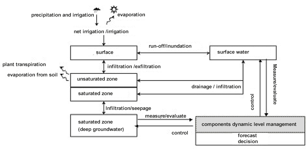
In this system, dynamic level management is used to adjust water levels in weirs and pumping stations (surface water) in order to influence groundwater levels (saturated zone). The weir or pumping station level represents the water level where the pumping station becomes active/is activated. The minimum level is the level below which supply takes place. The maximum level is the level above which discharge takes place. In this way, water level management is the adjustment of weir maximum and/or minimum levels. Dynamic level management ensures an increase of water quantities that need to be discharged and taken in (Borren, 2010).
Requirements consist of:
- water gauge pipes
- adjustable weirs
- water intake / discharge pumping stations
- monitoring stations for precipitation and evaporation
- A calculation method or a set of decision-making guidelines, based on which the present (and possible expected) situation and the desired situation are used to determine how the pumping stations and weirs should be set or adjusted
- If weather expectations are used: the calculation method is to estimate the expected situation in the next few days from the current hydrological situation.
Technical specifications
Dynamic water level management is used to prevent certain areas becoming too wet or too dry for too long (during certain periods). In addition, the goal could be striving to mitigate subsidence due to peat degradation (and settlement).
The objective of dynamic level management is to influence the groundwater level by means of adjusting the surface water level. The degree and the speed with which the level adjustments progress depends on many factors such as type of soil, distance to the ditch, presence of drainage, present water level, pressure difference between the surface water level and the groundwater level, permeability, storage coefficient and infiltration resistance.
Groundwater level is controlled by means of varying the surface water levels. Precipitation and evaporation serve to estimate the current and future groundwater levels. The process proceeds as follows:
- measuring on location (monitoring well)
- monitoring network
- data collecting
- data adjustment to other data (such as weather conditions and possibly weather forecasts by KNMI)
- decisions regarding action to take based on calculation model or decision rules
- feedback loop with control to weirs and pumping stations to adjust water levels.
It should be noted that underwater drainage will accelerate the process (see experience).
The following parameters are used to ascertain the effect of dynamic water level management:
- Intake
- Discharge
- Water quantity
- Soil samples (indicate the moisture condition in the root zone for instance)
- Groundwater level (measuring wells can be used to ascertain whether there is much resistance around the ditch, whether subsequent capillary action can be expected (critical z-distance))
- Surface water level
- Precipitation and evaporation
Preconditions and likely locations
The first precondition is that the area has been designated as a level control area in the water plan for the area by the water board concerned. Furthermore, the sizes of the level compartments play a role. The larger the compartments, the better the dynamic level control can be introduced. Often, the compartments are divided into small segments and some subdivisions are under pumping control of third parties (whether legal or illegal). The measure is more likely to succeed if there is a clear and rapid relation and interaction between groundwater and surface water levels. Dynamic level control will then have more effect and the possibilities of timely anticipation are increased.
Governance
Dynamic level management is intensive (expensive) and keeps ‘compromising’ between the interests of farmers and nature. For agricultural use, the preference is to have a water level that is as low as possible in the spring and autumn while, for ecological reasons, a wet spring is preferential and high water levels also help to limit peat land destruction (all year round but certainly in summer) which requires the highest groundwater levels possible.
To create support for dynamic level control it is very important that the benefits for farmers and public bodies are quantified.
Costs and benefits
Because of more intensive use of pumping stations (more intake and discharge) this increases the requirements for the available system capacity regarding water supply and discharge and the required monitoring (management and maintenance), so this is an expensive measure. In addition, at suitable locations monitoring wells have to be equipped with telemetry to enable real-time monitoring. To execute dynamic level management requires an operational system with a model running continuously (modelling tools) in order to forecast and anticipate on conditions.
The benefits can be found in the improved agricultural yields and a slight decrease in subsidence that results in lower costs for water management, sewerage and road maintenance. If dynamic level control is combined with underwater drains, subsidence will decrease substantially. As yet, it is unclear who will have to carry the costs for dynamic level management.
Projects and currently active research
Field experience at the Hoogheemraadschap De Stichtse Rijnlanden (HDSR) shows that groundwater levels can certainly be increased but that in the peat land area concerned, rather than in a few days or weeks, it is a process of 1-3 months (HDSR, 2011). In relation to groundwater levels and subsidence, dynamic level control seems to work better in combination with underwater drainage. However, the effect of dynamic level control on groundwater levels (and therefore also on limiting subsidence) is slight, even if the protocol permits substantial level variation (for instance a margin of 35 cm). A very large margin cannot be executed in practice and in addition, it takes too long for the effect (groundwater level change) to occur (HDSR, 2011). For this reason, HDSR is of the opinion that ‘dynamic level control’ without underwater drainage is insufficiently effective as an instrument that influences groundwater levels or as a tool to limit subsidence.
The Delta Programme contains on-going research into the combination of dynamic level control and underwater drains in Groot Salland. The combination with underwater drains is particularly interesting in peat land areas because the effect will be larger and more rapid here. Livestock Research completed research in fields trials at Zegveld, commissioned by the provincial authority Utrecht, focused on the implementation strategy of dynamic level control at plot level and the effect of underwater drains. The starting point is that the water level is kept high all year round and that, in view of operational yield, there is a temporary decrease when the plots are being used. The most important results of this research is the clear influence that underwater drains have on the substantial increase of groundwater levels when using dynamic level control at plot level (Hoving et al, 2013). The water board Aa en Maas is executing an experiment on made-to-measure level management (see experience).
The same water board is executing the Level Management 3.0 project (Peilbeheer 3.0) in which information controlled level management is being worked out. Remote sensing supplies information about the water demand and could eventually supply information on soil moisture and, together with other sources of information, create a high-tech operating system for effective water management. The satellite data is linked to groundwater models, which makes it possible to field-test the usability of the information (SAT-Water, 2013).
In addition, 9 water boards have joined forces and purchase satellite based data daily on evaporation, evaporation shortage, precipitation /storage shortage and biomass production (Verkerk et al, 2012). This information is used to ascertain whether a new add-on can be developed for operational level management. This new tool is aimed at generating better in-situ measurements, groundwater and surface models focused on level management in dry periods, for water level managers and farmers.
Knowledge gaps
Still to be researched are operational possibilities of water management. As yet, there is also uncertainty, in the time horizon for forecasting, to pro-actively execute dynamic water level management.
The design of the monitoring network with regard to how often and where groundwater levels are measured, offers many possibilities for improvement. Besides operating on groundwater levels, it is worth considering expanding the modelling instruments with crop growth models so that the effect of dynamic level management can be calculated on transpiration, evaporation and crop yield. A crop yield simulation could possibly show that dynamic level control will make optimal crop growth possible. This would make it easier to mobilize farmers to embrace dynamic level control. Optimizing crop yield will also prevent the soil profile from becoming too wet during the growth season and not storing summer showers, which means that much more water will have to be pumped out. The model ‘Waterpas’ (De Vos et al., 2006) is an integrated model in the field of soil, hydrology, grass growth and pasture use and the calculations are on a daily base. At present, it is solely a model for budget calculation and not an operational calculation model however, there is movement in this direction.
Another point of attention is ascertaining the water requirements per pumping station area and the water availability (HDSR, 2011). In addition, research should be done into the effects of the intake and discharge of non-local water and long-term water quality in the polders.
Experiences
Level management – custom made
Interview on 27 July 2011 with Jack de Wilt, Water board Aa en Maas
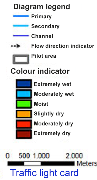
Water board Aa en Maas commenced with custom-made level management to find an effective method for conserving groundwater. They want to investigate whether this method increases the amount of water available for agricultural use in dry seasons. A buffer in groundwater is created by increasing the water level early in the season, in order to use it for crop evaporation later on.
The water board does use a summer and a winter level but makes optimal use of the available margins. The pilot ran from November 2010 up to and including May 2011. A traffic light card was developed for the pilot. To provide insight into the groundwater levels, the area was subdivided into smaller areas and representative monitoring wells were installed. The monitoring wells show six classifications in relation to the condition of the groundwater – from extremely wet to extremely dry. The classification was made based on historical data series. The output was the Traffic light card. The water manager is given advice on whether to move towards a more average situation or whether to increase the groundwater buffer, based on the Traffic light card.
The pilot period has been too short as yet to make a quantitative statement
about system performance but the findings of local stakeholders were purely positive. For this reason, an administrative process has been started in which discussions are taking place on whether another pilot should be executed or whether the current system should be expanded to include other areas.
For more information, please see the website of Aa en Maas
Trial dynamic water level management (2008-2010)
Interview on 21 June 2011 with Linda Nederlof, HDSR (Hoogheemraadschap De Stichtse Rijnlanden).
In this trail, the objective of HDSR was to use dynamic water level management (as opposed to classical summer and winter water levels) to resolve a number of challenges:
- increase agricultural yield reduction and improve the manageability of intake and discharge of surface water in the area
- reducing subsidence
- improving the quality of surface water
- boosting possibilities to take advantage of changing weather conditions and varying water levels
The expectation that agricultural business operation would benefit from the implementation of dynamic water level management did not become a reality. The effect of dynamic water level management on groundwater levels (and therefore also on mitigating subsidence), with a protocol margin of 35 cm, was slight. In practice, a margin of 35 cm proved to be too large to execute.
In addition, there are aspects of dynamic water level management (without underwater drains) that are clearly being experienced as negative (HDSR 2011):
- reduced storing capacity when there are substantial summer rain showers
- the (calculated) increase of intake and discharge of water for executing dynamic water level management. A supplementary question that arose (and not addressed in this study): is there sufficient water available for intake and what is the effect of large non-local water intake on the peat land area?
- the crumbling of the banks, due to being trodden on by grazing animals, if large level variations are applied.
There are a number of sensitivities among stakeholders concerning dynamic water level management:
- Farmers are reluctant due to the extra costs
- LTO Woerden is reticent as they have limited insight into where things are and what farmers are entitled to with regard to a fixed / season dependent water level
- The Forestry Commission is hesitant regarding the long-term effects on bio-diversity in the shallow subsurface and the indirect effects on the bird population.
In short, HDSR is of the opinion that dynamic water level management without underwater drains is an unsuitable instrument for influencing groundwater levels or slowing down subsidence.
At present, HDSR is pursuing a pilot with underwater drains. However, no clear administrative position has been taken on underwater drains as yet. A decision is expected at the end of 2011 or early in 2012.
Introducing underwater drains in peat land areas
Practical experience with underwater drainage
Underwater drainage is a tool for dynamic water level management, particularly in the peat land areas, as this can augment the positive effects of higher groundwater levels during summer.
Managing on groundwater levels does not work well because groundwater does not respond rapidly to the water level in a ditch. This means that we have to over-correct with margins that are much higher and lower than ditch levels, which requires pumping in large quantities of water and pumping out large quantities of water and, finally an extra large intake.
A disadvantage of underwater drains is the extra intake requirement. Dynamic managing by means of groundwater levels with a target level margin of 10 cm above or below ditch target level results in an increased intake demand compared to regular levels. A dynamic level whereby the goal was to limit the intake requirement did work (Jansen et al., 2009).
Van den Akker et al. (2010) executed field tests in three locations in the framework of research for the application of underwater drains in peat land areas: Praktijkcentrum Zegveld, Van Leeuwen in Linschoten and in the Zeevang polder.
The profitability of dairy farms showed a positive effect owing to the underwater drains as this not only yielded a 50% reduction in subsidence but also the remaining subsidence was more evenly spread and thereby preventing the creation of hollow plots (Van den Akker et al., 2010, p. 6).
In relation to water quantity it appeared that the application of underwater drains results in groundwater fluctuations closer to ditch level and the groundwater/surface water system reacts more rapidly and more effectively than is the case when there are no underwater drains (Van den Akker et al., 2010, p.8). This was also one of the most important results in the research of van Hoving et al (2013). Furthermore, it showed that it would be financially profitable to install underwater drains for the quality (limiting mineralization nutrients) if the limitation of CO2 emissions due to peat oxidation would yield tradable CO2 emission rights.