 English resume
Climate change/urban groundwater management
This fact sheet provides an overview of the collected, generated and compiled information on the possible effects of climate change on urban groundwater.
|
Thema |
Ruimtelijke adaptatie, Delta facts, English versions |
|
Tags |
|
|
Downloads |
- INTRODUCTION
- STRATEGY
- TECHNICAL SPECIFICATIONS
- PROMISING MEASURES
- COSTS AND BENEFITS
- GOVERNANCE
- FIELD EXPERIENCE AND CURRENTLY ACTIVE RESEARCH
- KNOWLEDGE GAPS
- RELATED TOPIC AND DELTA FACTS
- EXPERIENCES
Introduction
Urban groundwater usually drums up attention during wet seasons, when crawl spaces become flooded and rising water causes damage. But urban areas also incur damage from low groundwater levels, including differential settlement, wood rot, cracks in roads and underground infrastructure, and increasing flood events and flooding risks due to subsidence. All this attests to the importance of efficient groundwater level management.
The damage processes driven by low groundwater levels, however, occur gradually and are usually only recognised when the damage has already been done. This, together with the simple fact that groundwater is not visible, means that the urban groundwater file does not always get the attention it deserves. Climate impact research, however, highlights the real and present risk of a more dynamic groundwater table, which will more than likely amplify the processes that already lead to damage.
Over the past three years, the Delta Programme and other climate-related programmes have collected, generated and compiled extensive information on the possible effects of climate change on urban groundwater. This fact sheet provides an overview of this information.
Strategy
(1 Prevention, 2 Spatial planning, 3 Crisis management)
Changes in the groundwater table due to climate change do not lead to safety concerns, but to flooding and damage.
Climate change
The four climate scenarios of the KNMI (Royal Netherlands Meteorological Institute) project higher average groundwater levels in the winter and spring and lower average water levels in the summer and autumn (KNMI, 2006; Klein Tank & Lenderink, 2009), with more pronounced seasonal fluctuations. Furthermore, according to the W+ scenario, higher precipitation deficits could lead to more frequent low groundwater levels. Thus, if the low groundwater levels in the summer cannot be adequately compensated in the winter, there is a very good possibility that the average groundwater levels in some locations will be much lower in the summer and winter than is currently the case (Stuurman et al., 2007: Pg 60; Klein Tank & Lenderink, 2009; DHZ, 2012).
Technical specifications
Types of urban water systems in the Netherlands
Water demand in urban areas is primarily established by the surface water level management that is determined by the prevention of subsidence of buildings, roads, dikes, sewers and other structures. On the other hand, water is needed for replenishment and flushing to help maintain the urban surface water quality.
The level of water demand and the routes via which water is supplied vary from urban area to urban area. Each urban area has a water system with its own set of specifications, needs and bottlenecks. Hence, the broad distinction that is made between the urban areas in the Dutch lowlands (on clay and peat) and the urban areas in the Dutch highlands (on sandy soils). The main differences are associated with this distinction. In Category 1 urban areas, surface water level management and flushing are common practices, while Category 2 urban areas typically lack area-wide level management and the watercourses are rarely flushed due to the absence of an interconnected network of watercourses (Hoogvliet et al., 2012).
Consequences of excess precipitation and high groundwater levels
The KNMI climate scenarios show a higher incidence of extreme rainfall events, which can present a number of problems in urban areas, as described below.
Some of the rain that falls on roofs and pervious and impervious surfaces remains standing until it evaporates, and some infiltrate pervious surfaces. During very intense precipitation events, however, rainfall collects into runoff and discharges into the sewer system. In a mixed system, this water is discharged to the wastewater purification plant together with the domestic wastewater. But when heavy rainfall overwhelms the sewer system, the excess water and all the untreated waste flow directly into the urban surface water, and likely create acute water quality problems.
During extreme precipitation events, it is usually impossible to prevent the accumulation of standing water on streets. Not only can this cause traffic obstructions, but also damage to buildings, critical infrastructures and goods - not to mention the public health risks that are posed by the bacteria and pollutants in the water.
Rain on unpaved surfaces percolates into the groundwater, causing it to rise and create a host of problems, such as wet crawl spaces, mould in buildings and health problems for residents. Increased groundwater level under roadways can also contribute to instability of foundations. It renders buildings with basements vulnerable to damage from cracks and leaks, and exposes plants to root-zone oxygen deficiency, and thus root damage, thereby increasing the risk of trees toppling over. Figure 1 shows the areas at risk of groundwater flooding in the Netherlands.
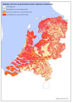
- Figure 1. Areas at risk of groundwater flooding, regional scale
Consequences of water shortage and low groundwater levels
In some KNMI climate scenarios the summer precipitation deficit increases. In such cases, the groundwater level will be lower in the summer than it is today. This is referred to as ‘groundwater overdraft’ as it typically triggers damage. Known, current causes of groundwater overdraft are leaking sewer systems, which act as drainage systems, and water uptake by tree roots.
When the groundwater level drops below the drainage level, it dries out the drainage pipes and accelerates the clogging process. The loss of soil water decreases the cooling effect of evaporation, which in turn, increases the probability of heat stress (National Institute for Public Health and the Environment, 2011). Groundwater overdraft can lead to wood rot, subsidence and differential settlement, and subsequently to foundation and infrastructure damage.
Types of climate-change-induced damage in urban areas
The figure below shows the types of damage mechanisms that are affected by fluctuations in ground and surface water levels. The arrows indicate movement of water in the system. The figure applies to urban areas in the Dutch lowlands.
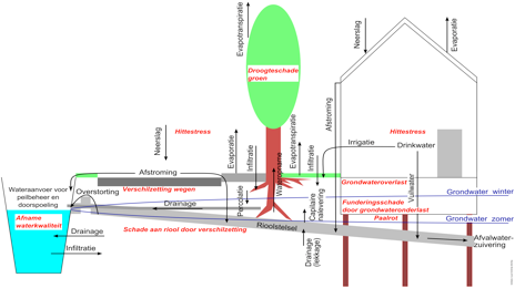
Figure 2. Street-level water system in the Dutch lowlands
The following types of damage can be expected to occur in urban areas as a result of climate change:
Flooding caused by longer and heavier precipitation events
- Standing water on streets
- Possible public health hazards from bacteria and other pollutants in rainwater
- Compromised water quality
- Indoor flooding (homes, basements, crawl spaces)
- Network failures
Overdraft caused by increasing precipitation deficit and decreasing water supply
- Drought damage to vegetation
- Subsidence of and damage to property, infrastructure, cables and piping due to differential settlement
- Rotting of wooden pile foundations
- Heat stress
- Compromised water quality
The Dutch highlands face other problems than the Dutch lowlands. A major difference is the vulnerability to damage from water shortage. In the Dutch highlands, foundation damage rarely occurs as wooden piles are almost never used as foundation support and susceptibility to subsidence is generally very low. Other types of climate change effects, however, occur in both the Dutch high and lowlands.
The actual occurrence of damage depends predominantly on the sensitivity or vulnerability of landscaping, buildings, infrastructure, and the like, and to a lesser extent on exposure to higher or lower groundwater levels. For buildings, the construction period and location are the starting points for estimating vulnerability as typical construction methods and foundation technologies are used in specific periods and at specific locations (depending on the load-bearing capacity of the soil).
Promising measures
There are a multitude of measures that can help prevent or reduce damage caused by water surplus or shortage (Better building and site preparation/SBR, 2009; PBL, 2011). That said, not all measures are equally effective. Measures that score well among stakeholders include (Hoogvliet et al, 2012, p. 87):
- Construction of seasonal storage and recovery systems and water buffers on private and public land
- Less paving and/or pervious surfaces
- New construction without crawl spaces
- Adjustment of foundations.
- Small-scale storage and infiltration (e.g. crates, and for trees).
- Ribbed surfaces for temporary storage of surplus water.
- Groundwater-level-controlled drainage and infiltration, in combination with dynamic water level management (such as groundwater, or other water source, controlled surface water level, rather than surface water management based on groundwater level). The cost-effectiveness of this measure is still unclear.
Other options for foundation damage are insurance measures, such as a guarantee fund. Such a fund can provide advance payment for foundation repair, which can be repaid after the sale of the house.
Heat stress can be reduced by adapting the building practices in urban areas. Increased use of green infrastructure practices, such as green roofs and walls, trees along main highways, roads and streets and greening measures along slow traffic routes reduce heat stress during extremely hot periods (National Institute for Public Health and the Environment, 2011). In the Dutch highlands there is growing support for replacing surface water with landscaping measures as this would reduce odour nuisance and have a much more cooling effect, especially at night, than open water. Other specific measures include wet paving, temporary shading of streets and, last but not least, behaviour change (e.g. closing windows during the day, adjusting medications, wearing light clothing) (Gemeentewerken Rotterdam et al., 2011; Pötz & Bleuzé, 2012).
The key for successful adoption of these promising measures lies in the optimisation of the relationship between use functions, underground, surface water and the development of urban areas. For example, the supplying of water should not be the be-all and end-all solution to the water overdraft problem, but rather a component part of a solution that includes more efficient water use, reduction of vulnerability to shortages and use/creation of alternative, internal water sources within urban areas (‘2nd layer water supply’). In addition, damage can be reduced by soft measures such as measurements, alarms and adaptive behaviour.
As part of the Delta Programme, a variety of measures have already been identified and a number of websites are being developed for providing information on measures.
Costs and benefits
There is greater transparency and improved analysis of the rising costs imposed by climate change on groundwater management in urban areas. The benefits of these measures are mainly expressed as avoided damage.
Specific cost items that may rise as a result of climate change include:
- Foundation damage to structures as a result of groundwater overdraft.
- Loss of productivity due to heat.
In addition, experts expect significant adverse effects to occur as a result of (Hoogvliet et al., 2012):
- More frequent (groundwater) flood events.
- Hospital admissions and costs of mortality.
- Desiccation of vegetation.
- Land and infrastructure damage due to subsidence and differential settlement.
Where the last two items are concerned, there is still a dearth of sufficient quantitative data available to estimate the rate of increase due to climate change. Conservative estimates are provided for the first two cost items.
In 2000, at least 100,000 households in the Netherlands experienced significant groundwater overdraft. Assuming an average EUR 54,000 in foundation repair damages, this translates into a cost item of about EUR 5 billion for repairs. Because this item is related to a claims process that is currently underway, it is likely that the amount of damages will increase in the future, partly because of climate change (Hoogvliet et al., 2012, p. 43 ).
The financial consequences of increased heat stress vary by climate scenario; in July and August 2050, this will be anywhere between EUR -3.7 million and 22.7 million in additional hospital admissions and the costs of mortality. The financial loss incurred from the loss of productivity varies from EUR 0 in the G scenario to EUR 391 million per year in the W+ scenario (Hoogvliet et al., 2012).
If the demands posed by the physical system and climate change are consistently taken into account in the development and redevelopment of urban areas in the coming decades, climate adaptation can be integrated at the lowest possible cost. A good number of the possible measures are virtually costless, if carried out simultaneously (PBL, 2011). For example, when executing major maintenance of the sewer systems, drainage measures to reduce water surpluses or shortages can be realised at the same time. The possibilities and financial feasibility of linking the effects of climate change vary widely among growing and shrinking regions and climate scenarios.
Governance
In recent years, there have been many changes in environmental law, especially due to the adoption of the Municipal Water Tasks Act and the Water Act. This has sometimes led to confusion about the responsibilities of the various authorities. The municipality, water board and homeowners have different responsibilities within urban groundwater management.
The municipality has a duty of care with respect to groundwater. In other words, the municipal council is responsible for taking measures within the public space of the municipality (and not on the landowner’s land) to prevent or limit structurally adverse consequences of the groundwater level on the use to which municipal land is to be put (Sterk consulting & Colibri recommendation, 2012: p. 18). The municipality also has a duty to collect and process excess groundwater.
The water board is the water manager for regional waters and is responsible for making level decisions, issuing water permits or exemptions and general regulations concerning the discharge of wastewater into public sewage or into the soil, carrying out surface water level management or implementing projects involving changes to the course or scope of groundwater bodies (Sterk consulting & Colibri recommendation, 2012: p. 12). The water board’s decisions have bearing on the groundwater table in the city.
The homeowner is responsible for the condition of his property and land, and is liable for any loss or damage that may arise from failure to discharge these responsibilities. According to case law, the homeowner is responsible for preventing encroachment of groundwater onto his land, in, under and around his property. The same applies to water shortage problems. In addition, the homeowner may not cause nuisance to owners of other immovable properties by altering the course, quantity or quality of the (ground)water that is flowing over his property (Sterk consulting & Colibri recommendation, 2012: p. 18-19).
In practice, a municipality formulates the urban groundwater policy and the water board enforces it. Coordination of policy and enforcement is important for efficient groundwater management. Better cooperation can result in better monitoring and thus in taking measures when and where needed to minimise damage and reduce or prevent the effects of climate change.
Responsibility issues
Urban groundwater management is often plagued by responsibility issues. If a municipality alters the groundwater level, it is also responsible for the consequences. Large differences in foundations of structural units, for example, have created less than desirable groundwater levels across the Netherlands. Thus, municipalities tend to be much more cautious about initiating measures for fear of getting embroiled in potential legal problems.
The introduction of the duty of care for groundwater has meanwhile led to higher monitoring efforts and drainage rate increase. Municipalities will likely step up their groundwater management efforts, while being mindful of potential technical and legal problems.
Many homeowners are unaware that they have a responsibility to manage the groundwater on their land. Homes rarely come with a ‘brochure’ with information about foundation, drainage and the required maintenance. While people are incurring significant costs for repairing damaged foundations, they can do little to prevent damage from occurring. Specific information about vulnerability of buildings and exposure to groundwater flooding and overdraft enables them to assume this responsibility and to take all necessary action to prepare for drought or to maintain the drainage system before the winter season begins (Sterk consulting & Colibri recommendation, 2012).
Hold, store, discharge
In 2000, the Water Management Committee released a report, representing an important first step in the development of water management into a more spatially oriented policy. The core message is that we should avoid discharging all of the water directly into the larger watercourses. The discharge peaks should remain small to avoid overloading the larger water systems more than is absolutely necessary and to have water available for dry periods.
Solutions for rainwater infiltration are therefore being sought in urban areas. For there to be alignment with the policy, preparation of new construction sites must include rainwater infiltration combined with more drainage and perhaps even higher elevation of the construction site (Stuurman et al., 2007: p. 42). Another solution for increasing the infiltration capacity is the introduction of a levy on rainwater sewer system based on m2 of interconnected impervious surface per house (as in Germany).
Field experience and currently active research
In the sub-programme New Construction and Restructuring, programme component Climate-Proof City, within the Delta Programme, research is underway on groundwater management and climate change in urban areas. The programme component aims to reduce the consequences of flooding, drought and heat through spatial measures. An example is the area pilot Delft Southeast where measures against future effects of climate change are being developed with different stakeholders.
The Knowledge for Climate programme is currently conducting thematic research on climate-resilient cities. The aim of the programme is to strengthen the urban system’s adaptive capacity, while reducing its vulnerability to climate change. A number of case studies, including integrated water management, are conducted within the programme. The hotspots Rotterdam and the Haaglanden region are also being studied to determine their water storage and drainage capacity during extreme precipitation events (Knowledge for Climate, 2012).
Water managers require access to accurate and evidence-based information to support their water and climate policy. HydroCity, an online platform, facilitates this by bringing together relevant information about urban water management (including precipitation, evaporation, infiltration, etc.), establishing links between the information and providing accurate, information-based forecasts. This can contribute to a better understanding of the effects of climate change on urban water systems.
3Di is an innovative 3D flood modelling tool designed to provide more accurate flood and rainfall forecasts by producing detailed schematisations of the land and optimised simulations of flooding/precipitation/discharge models. It combines flooding/precipitation/discharge/groundwater/water quality calculations and provides immediate insight into the effects of measures. The information can be accessed online and is therefore transparent for all water managers. The model is still in development and is not yet widely used.
Many municipalities and water boards still lack an overall view of the urban groundwater system in their management area. The large number of (water) structures renders urban (geo)hydrology particularly complex and in some respects misunderstood and misrepresented. Due to different water levels, structural units and leaking sewers, developing a water balance estimation is sometimes next to impossible. Thus, an international effort is underway to change that. More and more research is being focused on urban (geo)hydrology as cities grow and demand on the capacities of the water chain and the water and soil system increases (Hoogvliet et al., 2012). For many municipalities, the first step is to survey the urban groundwater system by setting up a groundwater monitoring network. This is currently being done in many (larger) municipalities, such as Amsterdam, The Hague, Rotterdam, Roosendaal and Haarlem.
Knowledge gaps
The impact of climate change on urban groundwater management has largely remained unknown until recently. Research has helped narrow this knowledge gap, but there is still great uncertainty in the answers. This area of research is still in an infancy stage with many knowledge gaps to be filled.
What exactly does overdraft mean?
The definition of flooding has long been embedded in literature, but this is not the case for overdraft. The definition of overdraft differs from one person to another; some believe that overdraft occurs when a foundation stands dry for one day, while others define it as financial loss due to overdraft.
Urban water balance is the big unknown
The scope of the factors in the water balance of urban areas is a significant knowledge gap. Little accurate information is available about the quantity of water supplied via surface water and what quantity of precipitation is used for replenishing the soil, ground and surface water. One reason is the large heterogeneity of the physical system in urban areas and a lack of measurements. This makes measuring, understanding and modelling of urban water systems a challenging task.
Groundwater balance on private land is a big unknown
Due to the legally defined responsibilities, the municipality is not responsible for private land, which means that there are no measurement data available for these areas. Urban areas cover a substantial portion of the management area. If the municipality were allowed to perform measurements on private land, more certainty could be achieved about the urban groundwater system and possible bottlenecks.
(Cost-)effectiveness of measures is unclear
There are significant gaps in our understanding of the (cost-)effectiveness of many of the possible measures. Pooling experiences and preventive measures will help provide this understanding and at the same time serve as a useful form of knowledge exchange. What is already clear is that a number of measures proposed for making urban areas more water robust are virtually costless, if integrated with (re)development.
Quantitative insights
The current climate scenarios show that it is especially important for measures to take account into account the increasingly unpredictable climate and greater fluctuations, also in urban groundwater. Whether this will lead to undesirable effects depends largely on the extent and duration of the fluctuations and vulnerability of the functions (green landscaping, buildings, infrastructure, etc.). These effects cannot be quantified at this time. There is still too little information and too many uncertainties to make a meaningful quantitative analysis of the differences in the extent of damage among the four Delta scenarios.
What do regular management and maintenance mean, and how is damage defined?
Currently, many types of public space and infrastructure damage are deferred to the annual management and maintenance costs, and thus not explicitly reflected in the annual financial statements. In fact, these costs are no longer regarded as damages as they are incurred on a regular basis and people have become used to the expenditure (Hoogvliet et al., 2012).
Little innovation by industry
Industry is doing little in the way of innovation or in optimising technologies and methods for construction and maintenance of infrastructure, buildings and drainage. The lack of sufficient funding for research and knowledge development in this area is also a major barrier to innovation and competition.
Little information about vulnerabilities and damage
At present, the first groundwater flood or overdraft-related damage estimates must be based on damage figures and rough characteristics of buildings from a certain construction period in a certain type of area, for example. There are no ‘ready-to-use’, nationwide damage estimates available for any relevant damage mechanism. Estimates must currently be based on extrapolations and combinations of figures, which, by definition, are inaccurate and are thus nothing more than ballpark figures (Hoogvliet et al., 2012).
Groundwater table/subsidence relationship unclear
There is insufficient short and long-term information available about the relationship between the groundwater table and subsidence.
Related topics and Delta Facts
Keywords: Groundwater, urban water system, urban water management, groundwater shortage, groundwater flooding
Delta facts:Dynamic level management, Effects of climate change on agriculture, Effects of climate change on nature.
Experiences
While climate proofing the Amsterdam Rivierenbuurt, Waternet (the water company for Amsterdam and surroundings) came across a highly differentiated groundwater system. They observed large piezometric fluctuations within and just outside the neighbourhood, which generally force the water to flow south (see Figure 5). Within the neighbourhood, which has buildings with different foundation levels, several, shallow groundwater systems (i.e. the water level is closer to the ground surface and thus more exposed to temperature variations) have developed as a result of the draining effect of leaking sewers. Analysing the risk areas in the neighbourhood requires a detailed water balance assessment, but the foundation level differences complicate analysis. Issues such as these make it difficult to initiate measures for climate-proofing a neighbourhood.
A true custom solution can only be provided if a more reliable water balance estimate, based on more measurement data (also on private land, if applicable), can be drawn up and a model is able to operate on a smaller scale. The plans for the coming years, including groundwater plans, are reflected in the municipal water tasks plan of Amsterdam. Amsterdam is looking to create an area-wide and up-to-date data source on the groundwater situation and on the development and use of the subsoil. Research is currently also underway on measures to mitigate groundwater fluctuations resulting from climate change by developing a list of existing groundwater issues, analysing foundation and groundwater monitoring data and optimising the groundwater monitoring network.
Collaboration between the water board and the municipality will enable greater pooling of information and knowledge, which can eventually lead to a better understanding of the water balance. Waternet is an example of collaboration where water board and municipality operate together. They are one of the few municipalities that have made great advances in modelling risk areas within the city. A quick scan calculation was performed for the city. The first detailed model results were expected in 2013.

Figure 3. Amsterdam Rivierenbuurt water system (Jacco Kroon, 2011)