 English resume
Drought determines functions
The Netherlands struggles with substantial water shortages and drought damage in agriculture and in nature conservation areas, especially the sandy soils of east and south Netherlands.
|
Thema |
Zoetwatervoorziening, Delta facts, English versions |
|
Tags |
|
|
Downloads |
- INTRODUCTION
- RELATED TOPICS AND DELTA FACTS
- STRATEGY: HOLD, STORE, SUPPLY
- SCHEMATIC
- PERFORMANCE
- COSTS AND BENEFITS
- GOVERNANCE
- CURRENTLY ACTIVE PROJECTS AND RESEARCH
- KNOWLEDGE GAPS
Introduction
In a country that has estuaries and is blessed with a temperate climate, drought would seem to be a non-issue. Yet, the Netherlands struggles with substantial water shortages and drought damage in agriculture and in nature conservation areas, especially the sandy soils of east and south Netherlands. The demand for water will increase due to climate change and evaporation, while the rivers will discharge increasingly less water in summer.
Next to safety, the availability of sufficient fresh water is a key objective in the Delta Programme. Different solutions are possible, one of which is to decrease the water demand by adapting the spatial planning, going by the principle that water scarcity will be a determining and controlling factor in relation to spatial use. The Delta Fact ‘Drought determines functions’ addresses this issue.
Related topics and Delta Facts
Delta facts: Blue services, Soil moisture-based irrigation, Effects of climate change on agriculture, Effects of climate change on nature, Effectiveness of water intake , Rainwater lenses, Company water reservoirs.
Strategy: hold, store, supply
'Drought determines functions' is not a strategy that is included in the three water strategies ‘hold, store, supply’. It is a strategy of adapting to the existing situation of the moisture supplying capacity of the soil.
'Drought determines functions' is a spatial planning principle in which water (or better yet: the lack of water) is a determining factor for the adaptation of spatial layout. This principle can be viewed as an elaboration on the layered approach in spatial planning. According to the layers approach, considerations in spatial planning should take place in the sequence of three layers of succession patterns: ‘substratum’, ‘networks’ and ‘occupation’. The load capacity of the substratum determines what can be done in the other layers; the networks steer the occupation. The layers also represent a difference in dynamic speed: from slow (substratum) to rapidly changing. The layers approach was developed in the Fifth Report on Spatial Planning and is also the foundation for National Spatial Strategy. Figure 1 provides a schematic overview of the layers approach.
At the time of sweeping redistribution of land and spatial land consolidation, the importance of the substratum as a foundation for spatial planning gave way to technical feasibility. With the introduction of the layers approach in spatial planning, it seems to turn around again. To quote Lex Hartholt, former programme director Green Heart: “We just made everything we wanted wherever we wanted but now we have reached a point of transition, where technical feasibility ends and nature, water and climate are becoming more important points of focus. This applies to sustainability as well as to the cost perspective. For years now, the substrate has not been taken into consideration and this has resulted in currently having to spend billions in annual costs.” (NIROV, 2009). The layers approach has recently been applied more frequently in formulating structural policies on integrated area development and zoning plans.
The strategy behind the principle ‘Drought determines functions’ is that the water requirement, which includes damages due to drought, in sectors such as agriculture and nature can be decreased by adjusting to zoning according to function in spatial lay-out and planning. The point of departure is to adapt to the dynamics in natural environmental patterns and processes wherever possible. According to principle of ‘Drought determines functions’, this means that locations with ample water due to their position (for instance seepage flow) should contain functions that depend on high (ground) water levels. This means that the water is locally retained and used for a longer period of time and moreover, the water is not discharged without being used.
In this way, this strategy for zoning meets the basic principles as stipulated in the agreement on National Water Management (NBW): ‘no shifting challenges on’ and ‘holding on to water’ (from the triad ‘hold – store – supply’). This contributes to a structural solution for existing and expected increases in water shortages due to climate change, without shifting the water problems on to the surrounding areas. In practice however, many low locations in the landscape are currently affected by agricultural drainage that is geared to benefit crops that require low groundwater levels such as arboriculture, fruit cultivation, horticulture and arable farming. Changing this into pastures will already result in a substantial increase in groundwater levels (from groundwater level IV or VI to II or III) in maintaining an agricultural function. Rewetting to an increased in groundwater levels will require a changeover to wet nature or cane cultivation.
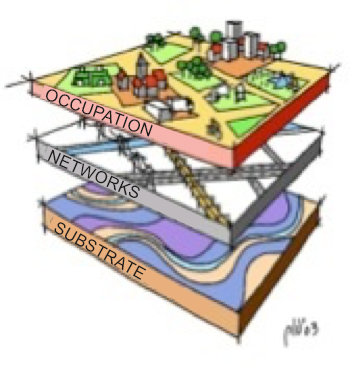
- Figure 1.The 3 layers in the layers approach (Source: www.ruimtexmilieu.nl)
Applying the principle of ‘Drought determines functions’ implicitly means abandoning the standpoint that it should be possible to apply optimal agricultural draining at every location. When areas with high water levels select functions that are able to tolerate certain variations in groundwater levels, or even inundation, the water manager is authorized to use this space for periodical water retention (water conservation) or temporary storage of peak water discharge (water storage).
Related to ‘Drought determines functions’ is the principle ‘Function follows water level’, which was developed as a zoning function concept for peat meadow areas. Both principles are geared towards increasing the groundwater level in the lowest parts. ‘Function follows water level’ is intended to slow down the subsidence due to dehydration and oxidation of the upper peat soil level. This principle reverses the usual sequence of redevelopment - the desired function is selected first and the required water level is set accordingly (‘Water level follows function’). ‘Water level follows function’ has resulted in increased level differences between rapidly subsiding lower plots and higher sections that were less vulnerable to surface subsidence. The principle ‘Function follows water level’ concerns larger areas for which a ditch water level is set according to the average surface elevation in the area concerned. This results in rewetting and therefore slowing down the surface subsidence in the lowest parts. In the project ‘What about the peat?’ several variants of this principle (higher ditch levels, underwater drains, flexible water level management) were developed to provide insight into their impact and effectiveness (Woestenburg, 2009).
In Beekdal (valley stream) landscapes, the height of the water level in the lowest part of the landscape feeds through into the water requirements and water shortages in the surrounding area. In the same way as ‘Function follows water level’, the concept ‘Drought determines function’ requires a redevelopment of soil use, particularly at the lowest part of the Beekdal where, in keeping with the natural environmental pattern, it can be wetter than elsewhere.
Schematic
The principle ‘Drought controls function’, applied in the Beekdal landscapes, corresponds with the 5B concept for sustainable layout of Beekdal (valley stream) landscapes (Verdonschot, 2010). Figure 2 shows the five zones distinguished by Verdonschot in an optimal design for valley streams:
- Stream: the wet part with a wide, shallow meandering rivulet or creek.
- Forrest zone: the accompanying forest growing on the banks of the stream.
- Woodlands: the transition zone from woods to buffer zone.
- Buffer zone: this is where substances from higher arable land are gathered.
- Stream side: the farmland situated outside the buffer.
The lowest three zones are such that periodical inundation is not a problem. According to the 5B concept, this means that it offers room for water conservation (Verdonschot calls this a sponge action) and for catchment of peak discharge, in combination with room for nature (development) and nature-oriented recreation.
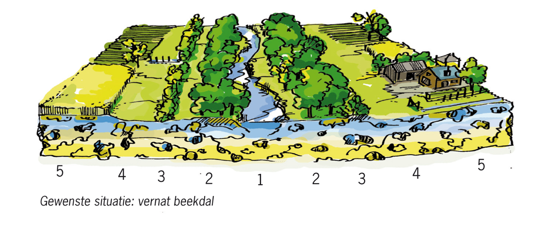
Figure 2. Layout of a Beekdal (valley streams) according to the 5B concept (Verdonschot, 2010).
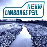
This concept was implemented by Water Board Peel and Meuse valley in the completion of the Desirable Groundwater and Surface Water Regime (GGOR). Together with provincial and local authorities, the agriculture and horticulture organization LLTB and the Forestry Commission this was elaborated on in the publication Nieuw Limburgs Pail (Water Board Peel and Meuse valley, 2010). In this vision the focus is not on the restoration of streams but on the restoration of complete rivulet valleys because valley streams are an important link in the restoration chain of the water system. This approach is currently being applied and developed in the Integral Design for Redevelopment Loobeek (Water Board Peel and Meuse valley, 2012).
The principle ‘Function follows water level’ is considered to be a regional implementation of the concept ‘Drought determines function’ for the peat land areas. A schematic overview of this principle is provided in figure 3. Even though peat land areas appear to be flat, there are often height differences due to differences in soil or substrate qualities (with or without clay cover) or hydrology (seepage or infiltration). If drained at the same time, the surface subsidence in the peat land areas with a clay cover is considerably slower than the subsidence in parts where there is no clay cover on top of the peat. Subsidence in a peat land polder can also occur owing to deeper drainage (for instance private drainage pumping) or because of substantial infiltration of the groundwater.
Figure 3 shows that the principle ‘Function follows water level’ in a peat land polder that is rich in relief will result in high water levels in low laying parts and lower groundwater levels in parts that are situated on higher ground. In the low parts, agriculture will have to adapt to wetter conditions.
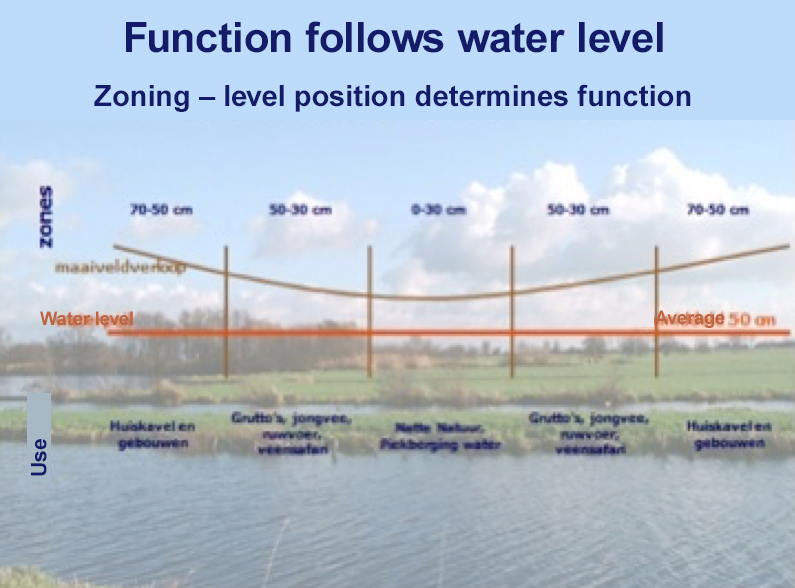
Figure 3. Function follows water level (www.blauweengroenediensten.nl)
Performance
The principle ‘Drought determines function’ is a spatial planning concept that is directed at reducing the water demand and water shortages in an area. The principle can be applied to structurally deal with current and future bottlenecks owing to water shortages and dehydration. According to this principle, water controls the position of the functions in an area. This means that before the principle is applied, it is important that the desired level of groundwater for an area is determined and the degree of fluctuation permitted is established in order to store sufficient fresh water in the area to meet the water demand, prevent drought damage and surface subsidence and, if possible, also limit or prevent damage due to flooding. If this means that redevelopment of functions is required, then spatial planning offers the necessary tools.
The principle is also suitable for adaptation measures related to climate change assuming that the water demand and water shortages will increase substantially due to climate change (Bottleneck analysis Delta Programme Fresh Water, 2011). With that, this principle also suits the concept regarding ‘climate buffers’: areas where natural environmental processes are given room, which allows them to grow together with climate changes (Coalition Natural Climate Buffers, 2012).
Costs and benefits
Costs and benefits of applying the spatial planning principle ‘Drought determines functions’ will have to be determined per area, as the nature, extent and impact of the required measures will differ per situation. Applying the principle in practice will require an integral and area specific approach, whereby mitigating water shortages and dehydration are part of a wider range of tasks such as improving the water quality, sustainability of agriculture or room for environmental development. Costs will mainly be generated by required transitions in agriculture (relocation, damage compensation) and spatial planning policy. The benefits could consist of the costs avoided (such as for management and maintenance), but are often also immaterial (such as increased environmental quality and the value of nature) which can hardly be expressed in money.
For some projects with measures based on ‘water controls the R.O.’, calculations were made of the cost/benefit balance and compared with the current situation in which water management is following rather than leading. For the Groot Mijdrecht Noord polder, it was calculated that the conversion of draining to this depth with intensive seepage from the surrounding area would yield a credit balance of 50 million Euros. The high cost of executing this plan and the loss of agricultural value is weighed against the higher benefits of improving water quality, living environment and income from recreation as well as decreased management and maintenance costs (Witteveen+Bos en ECORYS, 2006a).
A second example is a Social Cost and Benefit Analysis (MKBA) on the application of the concept ‘Function follows water level’ in peat land areas (Witteveen+Bos and ECORYS, 2006b; STOWA, 2009). For three areas in the western peat land areas (Krimpenerwaard, Groot Wilnis-Vinkeveen and Wormer- en Jisperveld), calculations were made regarding the costs and benefits of enlarging the water level area and increasing the average water level in the ditches with respect to the current situation. For the Krimpenerwaard this will lead to a rewetting of the most rapidly subsiding northern Krimpenerwaard. Existing agriculture will have to make way for extensive agriculture or nature. The southern part of the Krimpenerwaard will retain good agricultural drainage, as subsidence is less rapid owing to a higher percentage of clay in the soil. The costs mainly concern the removal of existing hydrological elements (such as level separations) and relocating farms. The benefits mainly consist of reduced water management cost, as the water management will become considerably less complicated in a number of level compartments. Additionally, there are nature and environmental effects, for instance due to a reduction in greenhouse gas emissions because of decreased peat oxidation. The results of the Social Cost and Benefit Analysis (MKBA) show that the ‘Function follows water level’ version with the highest levels of ditch water (an average of 30 cm –mv) has the best score and will lead to a positive cost and benefits balance for all three of the peat land areas.
Aside from that, the CPB (2006) did have critical remarks regarding this Social Cost and Benefit Analysis (MKBA). According to the CPB, the estimates on the environmental benefits of rewetting were too optimistic and it queries the estimated size of the investments costs saved by rewetting the peat land area.
Bos en Vogelzang (2006) executed a Social Cost and Benefit Analysis (MKBA) for a peat land polder of approximately 4,000 ha near Zegveld. This SCBA also yields a positive social cost/benefit result for a ‘Function follows water level’ scenario with increased ditch levels. An important explanation on why such SCBA do not directly result in a change over to the most favourable version can be found in the unequal division of costs and benefits between parties concerned. The costs are mainly for the account of agriculture while the water manager makes progress with decreased management costs.
An evaluation of Climate Buffer projects (Coalition Natural Climate Buffers, 2012) shows that a few projects might yield favourable social-economic results. It concerns the climate buffers Hunze, Regge, Weerterbos and IJsselmonde, directed at water conservation with the objective of reducing the water demand. The costs and benefits of these projects still have to be quantified in more detail.
Governance
For the principle ‘Drought determines functions’ it will first have to become clear which (ground) water levels are desired or permitted in an area, for instance in view of nature recovery or climate adaptation. This is stipulated in the Desirable Groundwater and Surface Water Regime (GGOR). A GGOR generally comes about in an interactive process between participating parties concerned (authorities, water and nature managers, farmers and other parties from business or social groups) as this promotes support for the end result. The GGOR is the policy framework for project execution, like the previously mentioned Integral Design for Redevelopment Loobeekdal (Noord Limburg).
A GGOR is finally ratified by the provincial authority and is part of the Provincial Water Plan. With the new Water Act, the Water Plan, insofar as it concerns spatial aspects, is a Spatial Structure Plan as intended in article 2.2 (second paragraph) of the Spatial Planning Act (WRO). The provincial Water Plan is not binding. If the Water Plan contains spatial policy statements that are in the interest of the province, the provincial authority can use Provincial Spatial Structure Plan as a Spatial Planning Act tool. The Spatial Structure Plan is a policy document that is non-binding; it can be deviated from if motivation is supplied.
If, based on the principle ‘Drought determines functions’, the desired groundwater level in an area is amended in the provincial Water Plan and accordingly also spatially stipulated in the Spatial Structure Plan, this amendment can be passed and ratified by means of a change of the valid municipal zoning plan. However, as previously stated, deviation is possible with motivation. Changes in municipal zoning to allow for the preferred groundwater level (in accordance with GGOR) with corresponding use of space will have to indicate the manner in which this change will be realized. An expropriation procedure is available within WRO though this can only be used for expropriation after all other possibilities for amicable settlement have been explored and rejected.
Currently active projects and research
The GGOR is based on knowledge about the hydrological preconditions for realizing function objectives (goal achievement). Gehrels et al. (2002) developed a method to weigh and compare conflicting hydrological function requirements (agriculture – nature) with alternatives based on goal achievement and function assessment. The method was developed and applied in Low Netherlands (the redevelopment area Reeuwijk) and High Netherlands (Strijbeekse Heide). The alternatives were focused on reducing water intake from other areas (Reeuwijk) and mitigating dehydration by closing up ditches. This method could be helpful in determining likely social situations for applying the principle ‘Drought controls function’.
Kessels (2012), in his analysis of the possibilities for reducing the water demand in the management area of Water Board AA en Maas, poses that there are no known concrete examples of using spatial planning tools to realize a reduction in water demand. The research does describe field experience from agriculture and industry that contributes to reducing the water demand.
In the Administrative Reporting about the Delta Programme Fresh Water (Programme Team Fresh Water, 2012) the effectiveness of regional and local measures are addressed briefly to meet the water demand, also in view of climate change. This regional approach is one of the possible fresh water strategies from the Delta Programme (‘Water determines spatial planning and the user’). This strategy utilizes the possibilities to realize more sustainable fresh water self-sufficiency on user level (by means of changes in spatial planning) in areas. This report comes to the conclusion that there is insufficient information as yet to come to a quantitative assessment of the efficiency of these kinds of measures. The Fresh Water Programme Team concludes that a change in spatial planning will require a trend-reversal in current policy and this makes it difficult to obtain information.
Calculations were made on how much space the Gronings-Drentse peat colonies would require to realize a self-sufficient water system in that agricultural area, which is currently supplied with water from the IJsselmeer (Querner et al., 2011). Calculations showed that approximately 7% of the arable land in the low lying parts will have to be converted into water conservation areas. Because of climate change the water demand will rise due to increased evaporation and the summer precipitation will decrease (in climate scenario W+). If this is the case, and additional 5% of arable land will be needed to obtain 100% regional water self-sufficiency. The realization of such a conversion will require considerable redevelopment according to the principle ‘Drought determines functions’. Expectations are that the future Common Agricultural Policy of the European Union (GLB) will be able to offer support for this.
The Delta Plan Agricultural Water Management (DAW) of the agricultural and horticultural organization LTO are in favour of more thrifty use of fresh water in view of the expected increase in water scarcity. In the execution phase of the DAW, these kinds of measures will be tested in field projects on farm and area level.
In a number of projects of the Coalition Natural Climate Buffers the possibilities for more efficient use of fresh water in nature development projects is being explored. The intention is to reduce the water demand once the change in function to nature area has been realized. An example of this is to collect and store seepage at the edges of the nature reserves of the climate buffers at Hunze en Regge.
The Knowledge for Climate research of Ellen et al. (2011) into multi-functional land use as an adaptive strategy in Noord-Brabant is relevant for insight into the process-related success factors (governance) at implementation of ‘Drought determines functions’. Methods like speed dating, Pecha Kucha and workshops could result in new partnerships between parties with different interests. The joint formulation of a business plan is a good means of clarifying the practical interpretation of the ‘Drought determines functions’ principle for all parties.
Knowledge gaps
To date, hardly any experience had been gained with limiting the water demand by means of a spatial redevelopment of functions. Therefore, ‘Drought determines functions’ actually is a theoretical principle. There are spatial planning concepts that have a relation with the principle ‘Drought determines functions’, such as the 5B stream concept of Verdonschot (2010) and the principle ‘Function follows water level’ (Bosch Slabbers, 2006) in peat land areas. However, the same applies here: practical experience is still in its infancy. There is substantial need for experiments or pilots on area level in order to obtain experience in process-related, economic and ecological aspects and gain more insight into the contribution that the principle ‘Drought determines functions’ has to offer the different areas types in providing solutions to the water challenges. The latter is urgent as the Delta Programme Fresh Water (2011, 2012) comes to the conclusion that very little is know about the effectiveness of adaptations in spatial planning and layout for the reduction in water demand.
More knowledge is required on how support can be obtained for water-driven spatial planning. Some research has been executed within the framework of SCBA (Social Cost and Benefit Analysis) and shows a positive cost/benefit balance if water is chosen as the guiding principle for spatial planning. Yet, this has hardly resulted in the application of this principle for project execution.
In addition, very little is known about the legal administrative consequences and possibilities that accompany the principle ‘Drought determines functions’ as there is hardly any practical experience within the current laws and regulations.